
地理空間分析の市場機会、成長促進要因、産業動向分析、2025年~2034年予測
Geospatial Analytics Market Opportunity, Growth Drivers, Industry Trend Analysis, and Forecast 2025 - 2034- 発行日
- ページ情報
- 英文 190 Pages
- 納期
- 2~3営業日
- 商品コード
- 1755187
- カスタマイズ可能 お客様のご希望に応じて、既存データの加工や未掲載情報(例:国別セグメント)の追加などの対応が可能です。詳細はお問い合わせください。
- 翻訳ツール提供対象 PDF対応AI翻訳ツールの無料貸し出しサービスのご利用が可能です
概要
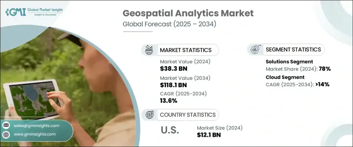
地理空間分析の世界市場規模は、2024年に383億米ドルとなり、農業、交通、防衛、都市計画など様々な産業で、位置情報サービスの採用拡大、スマートシティの市場開拓、リアルタイムデータ分析の利用が進み、2034年にはCAGR 13.6%で成長し、1,181億米ドルに達すると推定されます。
AI、IoT、衛星画像などの最先端技術の統合は、地理空間分析の能力とアプリケーションの強化に役立ちます。5G技術の展開は、より高速で信頼性の高いデータ伝送を提供することで貢献し、よりインテリジェントな意思決定プロセスのための地理空間アプリケーションの展開をサポートします。地理空間分析により、産業界は位置特定データを活用し、より優れた業務効率、予測分析、リアルタイムの洞察を得ることができます。
位置情報サービスに対する需要も、市場の成長を促す重要な要因です。小売、物流、運輸などの業界では、意思決定のための空間データへの依存度が高まっており、正確なマッピング、追跡、予測的洞察へのニーズが大幅に高まっています。このような位置情報サービス利用の急増は、より多くの企業が地理空間技術を業務に統合するにつれて、市場の拡大を加速させています。
| 市場範囲 | |
|---|---|
| 開始年 | 2024 |
| 予測年 | 2025-2034 |
| 開始金額 | 383億米ドル |
| 予測金額 | 1,181億米ドル |
| CAGR | 13.6% |
2024年、ソリューション分野のシェアは78%に達し、2034年のCAGRは13.5%と堅調な成長を続けると予測されます。地理情報システム(GIS)プラットフォーム、リモートセンシングツール、ロケーションインテリジェンスソフトウェアなどの主要ソリューションは、企業が膨大な量の空間データを効率的に処理・分析することを可能にします。これらのテクノロジーにより、企業は地理的パターンを理解し、リソース配分を最適化し、より多くの情報に基づいたデータ主導の意思決定を行うことができます。
地理空間分析市場のクラウド展開セグメントは、2024年に56%のシェアを占め、2025年から2034年にかけてCAGR 14%で成長すると予測されています。クラウドソリューションの台頭は、その拡張性、柔軟性、費用対効果に起因しており、企業はコストのかかるオンプレミスのインフラなしで大量の地理空間データを扱うことができます。クラウドプラットフォームは、リアルタイムのデータ処理や、衛星やIoTデバイスなどさまざまなソースからの情報の統合にも欠かせないです。これにより、災害管理やロジスティクスなど、一刻を争うシナリオにおいて、より正確な意思決定が可能になります。SaaSベースのプラットフォームが普及するにつれ、クラウドベースの地理空間ソリューションの採用が加速しています。
米国の地理空間分析市場は、防衛、交通、都市計画などの産業で地理空間データ分析の需要が高まっていることから、2024年には86%のシェアを占め、121億米ドルを創出しました。特に、国土安全保障、インフラ近代化、災害管理のための地理空間技術への政府投資が市場を牽引しています。さらに、公益事業、農業、物流における地理空間分析の採用が、さらなる拡大に拍車をかけています。AI、ビッグデータ、クラウドコンピューティングの技術革新は、高度な地理空間ソリューションの需要を強化しています。
世界の地理空間分析市場の主要企業には、Bentley Systems、Esri、Fugro、Google、Hexagon AB、IBM、Microsoft、Oracle、TomTom International、Trimbleが含まれます。市場での存在感を高めるため、技術力とサービス提供の拡大に注力しています。AI、機械学習、先進的なGISソリューションを活用することで、これらの企業はさまざまな業界でリアルタイムで場所に特化した洞察を提供する能力を高めています。さらに、クラウドベースのプラットフォームを採用することで、拡張性とコスト効率を優先し、より優れたデータ管理と分析サービスを提供できるようにしています。防衛、交通、都市計画などの業界との提携も、これらの企業が市場でのポジショニングを強化するのに役立っています。
目次
第1章 調査手法と範囲
第2章 エグゼクティブサマリー
第3章 業界考察
- エコシステム分析
- サプライヤーの情勢
- データプロバイダー
- テクノロジーおよびプラットフォームプロバイダー
- クラウドおよびインフラストラクチャプロバイダー
- システムインテグレーターおよびソリューション開発者
- エンドユーザー
- 利益率分析
- トランプ政権による関税への影響
- 貿易への影響
- 貿易量の混乱
- 他国による報復措置
- 業界への影響
- 主要原材料の価格変動
- サプライチェーンの再構築
- 生産コストへの影響
- 影響を受ける主要企業
- 戦略的な業界対応
- サプライチェーンの再構成
- 価格設定と製品戦略
- 展望と今後の検討事項
- 貿易への影響
- テクノロジーとイノベーションの情勢
- 特許分析
- 主なニュースと取り組み
- 規制情勢
- 影響要因
- 促進要因
- 位置情報サービス(LBS)の需要増加
- スマートシティプロジェクトへの政府投資
- 衛星画像およびリモートセンシング技術の成長
- 人工知能とビッグデータとの統合
- 農業と林業における導入の増加
- 業界の潜在的リスク&課題
- 初期投資とインフラコストが高め
- データのプライバシーとセキュリティに関する懸念
- 促進要因
- 成長可能性分析
- ポーター分析
- PESTEL分析
第4章 競合情勢
- イントロダクション
- 企業の市場シェア分析
- 競合ポジショニングマトリックス
- 戦略的展望マトリックス
第5章 市場推計・予測:コンポーネント別、2021年~2034年
- 主要動向
- ソリューション
- ジオコーディングおよびリバースジオコーディングソフトウェア
- 空間データ統合とETL
- レポートと視覚化
- テーマ別マッピングと空間分析
- その他
- サービス
- コンサルティングサービス
- 展開と統合
- トレーニング、サポート、メンテナンス
第6章 市場推計・予測:展開モード別、2021年~2034年
- 主要動向
- オンプレミス
- クラウド
第7章 市場推計・予測:組織規模別、2021年~2034年
- 主要動向
- 大企業
- 中小企業
第8章 市場推計・予測:タイプ別、2021年~2034年
- 主要動向
- 表面およびフィールド分析
- ネットワークと位置情報の分析
- 地理視覚化
- その他
第9章 市場推計・予測:技術別、2021年~2034年
- 主要動向
- リモートセンシング
- 地理情報システム(GIS)
- 全地球測位システム(GPS)
- 3Dスキャン
- 写真測量
第10章 市場推計・予測:最終用途別、2021年~2034年
- 主要動向
- 政府と防衛
- ユーティリティ
- 農業
- 建設・不動産
- 運輸・物流
- ヘルスケア
- 小売り
- エネルギー
- その他
第11章 市場推計・予測:地域別、2021年~2034年
- 主要動向
- 北米
- 米国
- カナダ
- 欧州
- 英国
- ドイツ
- フランス
- イタリア
- スペイン
- ロシア
- 北欧諸国
- アジア太平洋地域
- 中国
- インド
- 日本
- 韓国
- オーストラリア・ニュージーランド
- 東南アジア
- ラテンアメリカ
- ブラジル
- メキシコ
- アルゼンチン
- 中東・アフリカ
- アラブ首長国連邦
- サウジアラビア
- 南アフリカ
第12章 企業プロファイル
- Alteryx
- Bentley Systems
- Caliper Corporation
- Esri
- Fugro
- General Electric Company(GE Digital)
- Geospin
- Google LLC
- HERE Technologies
- Hexagon AB
- IBM
- Maxar Technologies
- Microsoft
- Oracle
- Precisely
- SAP SE
- Spatial Data
- TomTom International
- Trillium Data
- Trimble
目次
The Global Geospatial Analytics Market was valued at USD 38.3 billion in 2024 and is estimated to grow at a CAGR of 13.6% to reach USD 118.1 billion by 2034, driven by the increasing adoption of location-based services, the development of smart cities, and the use of real-time data analytics across various industries including agriculture, transportation, defense, and urban planning. The integration of cutting-edge technologies such as AI, IoT, and satellite imaging helps enhance the capabilities and applications of geospatial analytics. The rollout of 5G technology contributes by providing faster and more reliable data transmission, thus supporting the deployment of geospatial applications for more intelligent decision-making processes. Geospatial analytics allows industries to harness location-specific data for better operational efficiency, predictive analysis, and real-time insights.
The demand for location-based services is another key factor driving the growth of the market. As industries such as retail, logistics, and transportation increasingly rely on spatial data for decision-making, the need for precise mapping, tracking, and predictive insights has grown substantially. This surge in location-based service usage is accelerating the market's expansion as more companies integrate geospatial technologies into their operations.
| Market Scope | |
|---|---|
| Start Year | 2024 |
| Forecast Year | 2025-2034 |
| Start Value | $38.3 Billion |
| Forecast Value | $118.1 Billion |
| CAGR | 13.6% |
In 2024, the solutions segment held 78% share, and it is projected to continue to grow at a robust CAGR of 13.5% during 2034 driven by the increasing need for accurate, real-time geospatial insights across multiple sectors. Key solutions, such as Geographic Information System (GIS) platforms, remote sensing tools, and location intelligence software, enable organizations to process and analyze vast amounts of spatial data efficiently. These technologies empower businesses to understand geographic patterns, optimize resource allocation, and make more informed, data-driven decisions.
The cloud deployment segment of the geospatial analytics market dominated in 2024 with a 56% share and is anticipated to grow at a CAGR of 14% from 2025 to 2034. The rise of cloud solutions is due to their scalability, flexibility, and cost-effectiveness, enabling organizations to handle large volumes of geospatial data without costly on-premises infrastructure. Cloud platforms are also crucial for real-time data processing and integrating information from various sources, such as satellites and IoT devices. This allows for more accurate decision-making in time-sensitive scenarios, such as disaster management and logistics. The adoption of cloud-based geospatial solutions is accelerating as SaaS-based platforms become more prevalent.
U.S. Geospatial Analytics Market held an 86% share and generated USD 12.1 billion in 2024 due to the increasing demand for geospatial data analytics across industries such as defense, transportation, and urban planning. Government investment in geospatial technologies, particularly for homeland security, infrastructure modernization, and disaster management drives the market. Additionally, adopting geospatial analytics in utilities, agriculture, and logistics is fueling further expansion. Technological innovations in AI, big data, and cloud computing bolster the demand for advanced geospatial solutions.
Key players in the Global Geospatial Analytics Market include Bentley Systems, Esri, Fugro, Google, Hexagon AB, IBM, Microsoft, Oracle, TomTom International, and Trimble. To strengthen their market presence, focus on expanding their technological capabilities and service offerings. By leveraging AI, machine learning, and advanced GIS solutions, these companies are enhancing their ability to provide real-time, location-specific insights across various industries. Additionally, adopting cloud-based platforms is being prioritized for their scalability and cost efficiency, allowing companies to provide better data management and analytics services. Partnerships with industries such as defense, transportation, and urban planning are also helping these players enhance their market positioning.
Table of Contents
Chapter 1 Methodology & Scope
- 1.1 Research design
- 1.1.1 Research approach
- 1.1.2 Data collection methods
- 1.2 Base estimates and calculations
- 1.2.1 Base year calculation
- 1.2.2 Key trends for market estimates
- 1.3 Forecast model
- 1.4 Primary research & validation
- 1.4.1 Primary sources
- 1.4.2 Data mining sources
- 1.5 Market definitions
Chapter 2 Executive Summary
- 2.1 Industry 3600 synopsis, 2021 - 2034
Chapter 3 Industry Insights
- 3.1 Industry ecosystem analysis
- 3.2 Supplier landscape
- 3.2.1 Data providers
- 3.2.2 Technology and platform providers
- 3.2.3 Cloud and infrastructure providers
- 3.2.4 System integrators and solution developers
- 3.2.5 End users
- 3.3 Profit margin analysis
- 3.4 Trump administration tariffs
- 3.4.1 Impact on trade
- 3.4.1.1 Trade volume disruptions
- 3.4.1.2 Retaliatory measures by other countries
- 3.4.2 Impact on the industry
- 3.4.2.1 Price Volatility in key materials
- 3.4.2.2 Supply chain restructuring
- 3.4.2.3 Production cost implications
- 3.4.3 Key companies impacted
- 3.4.4 Strategic industry responses
- 3.4.4.1 Supply chain reconfiguration
- 3.4.4.2 Pricing and product strategies
- 3.4.5 Outlook and future considerations
- 3.4.1 Impact on trade
- 3.5 Technology & innovation landscape
- 3.6 Patent analysis
- 3.7 Key news & initiatives
- 3.8 Regulatory landscape
- 3.9 Impact forces
- 3.9.1 Growth drivers
- 3.9.1.1 Rising demand for location-based services (LBS)
- 3.9.1.2 Government investments in smart city projects
- 3.9.1.3 Growth of satellite imaging and remote sensing technologies
- 3.9.1.4 Integration with artificial intelligence and big data
- 3.9.1.5 Increasing adoption in agriculture and forestry
- 3.9.2 Industry pitfalls & challenges
- 3.9.2.1 High initial investment and infrastructure costs
- 3.9.2.2 Data privacy and security concerns
- 3.9.1 Growth drivers
- 3.10 Growth potential analysis
- 3.11 Porter's analysis
- 3.12 PESTEL analysis
Chapter 4 Competitive Landscape, 2024
- 4.1 Introduction
- 4.2 Company market share analysis
- 4.3 Competitive positioning matrix
- 4.4 Strategic outlook matrix
Chapter 5 Market Estimates & Forecast, By Component, 2021 - 2034 ($Bn)
- 5.1 Key trends
- 5.2 Solution
- 5.2.1 Geocoding and reverse geocoding software
- 5.2.2 Spatial data integration & ETL
- 5.2.3 Reporting & visualization
- 5.2.4 Thematic mapping & spatial analysis
- 5.2.5 Others
- 5.3 Service
- 5.3.1 Consulting services
- 5.3.2 Deployment and integration
- 5.3.3 Training, support, and maintenance
Chapter 6 Market Estimates & Forecast, By Deployment Mode, 2021 - 2034 ($Bn)
- 6.1 Key trends
- 6.2 On-premises
- 6.3 Cloud
Chapter 7 Market Estimates & Forecast, By Organization Size, 2021 - 2034 ($Bn)
- 7.1 Key trends
- 7.2 Large enterprises
- 7.3 Small and medium-sized enterprises (SME)
Chapter 8 Market Estimates & Forecast, By Type, 2021 - 2034 ($Bn)
- 8.1 Key trends
- 8.2 Surface & field analytics
- 8.3 Network & location analytics
- 8.4 Geovisualization
- 8.5 Others
Chapter 9 Market Estimates & Forecast, By Technology, 2021 - 2034 ($Bn)
- 9.1 Key trends
- 9.2 Remote sensing
- 9.3 Geographic information systems (GIS)
- 9.4 Global positioning system (GPS)
- 9.5 3D scanning
- 9.6 Photogrammetry
Chapter 10 Market Estimates & Forecast, By End Use, 2021 - 2034 ($Bn)
- 10.1 Key trends
- 10.2 Government & defense
- 10.3 Utilities
- 10.4 Agriculture
- 10.5 Construction & real estate
- 10.6 Transportation & logistics
- 10.7 Healthcare
- 10.8 Retail
- 10.9 Energy
- 10.10 Others
Chapter 11 Market Estimates & Forecast, By Region, 2021 - 2034 ($Bn)
- 11.1 Key trends
- 11.2 North America
- 11.2.1 U.S.
- 11.2.2 Canada
- 11.3 Europe
- 11.3.1 UK
- 11.3.2 Germany
- 11.3.3 France
- 11.3.4 Italy
- 11.3.5 Spain
- 11.3.6 Russia
- 11.3.7 Nordics
- 11.4 Asia Pacific
- 11.4.1 China
- 11.4.2 India
- 11.4.3 Japan
- 11.4.4 South Korea
- 11.4.5 ANZ
- 11.4.6 Southeast Asia
- 11.5 Latin America
- 11.5.1 Brazil
- 11.5.2 Mexico
- 11.5.3 Argentina
- 11.6 MEA
- 11.6.1 UAE
- 11.6.2 Saudi Arabia
- 11.6.3 South Africa
Chapter 12 Company Profiles
- 12.1 Alteryx
- 12.2 Bentley Systems
- 12.3 Caliper Corporation
- 12.4 Esri
- 12.5 Fugro
- 12.6 General Electric Company (GE Digital)
- 12.7 Geospin
- 12.8 Google LLC
- 12.9 HERE Technologies
- 12.10 Hexagon AB
- 12.11 IBM
- 12.12 Maxar Technologies
- 12.13 Microsoft
- 12.14 Oracle
- 12.15 Precisely
- 12.16 SAP SE
- 12.17 Spatial Data
- 12.18 TomTom International
- 12.19 Trillium Data
- 12.20 Trimble
- 発行日
- 発行
- Global Market Insights Inc.
- ページ情報
- 英文 190 Pages
- 納期
- 2~3営業日