|
|
市場調査レポート
商品コード
1577109
商用地球観測市場の2030年までの予測: データタイプ、サービス、技術、用途、エンドユーザー、地域別の世界分析Commercial Earth Observation Market Forecasts to 2030 - Global Analysis By Data Type, Service, Technology, Application, End User and By Geography |
||||||
|
|||||||
カスタマイズ可能
|
|||||||
| 商用地球観測市場の2030年までの予測: データタイプ、サービス、技術、用途、エンドユーザー、地域別の世界分析 |
|
出版日: 2024年10月10日
発行: Stratistics Market Research Consulting
ページ情報: 英文 200+ Pages
納期: 2~3営業日
|

全表示
- 概要
- 図表
- 目次
Stratistics MRCによると、世界の商用地球観測市場は2024年に51億6,000万米ドルを占め、予測期間中のCAGRは10.2%で成長し、2030年には92億4,000万米ドルに達すると予測されています。
商用地球観測(EO)とは、様々な商業用途のために衛星や航空画像やデータを取得・分析することを指します。これには、資源、インフラ、環境を監視、評価、管理するためのリモートセンシング技術の利用が含まれます。衛星データを活用することで、企業は土地利用、環境変化、市場動向に関する洞察を得ることができ、さまざまな産業における意思決定や業務効率を高めることができます。
インド宇宙局の2024年報告書によると、インド宇宙研究機関(ISRO)は、衛星システムに新技術を統合するEOS-08ミッションを開始しました。
地理空間データへの需要の高まり
農業、都市計画、環境管理などの産業は、土地利用、資源配分、気候監視に関する洞察のためにEOデータに依存しています。企業が意思決定と業務効率の向上を目指すにつれて、正確でタイムリーな地理空間情報に対する需要が高まっています。さらに、技術の進歩によりデータへのアクセスや分析が容易になり、投資が集まり、商用プロバイダーとエンドユーザーとの協力関係が促進されます。この動向は、市場の拡大とアプリケーションの多様化を強化しています。
データプライバシーに関する懸念
商用地球観測におけるデータ・プライバシーの懸念は、個人、インフラ、重要な資産に関する情報を含む可能性のある地理空間データの機密性から生じる。このデータへの不正アクセスや悪用は、国家安全保障や個人のプライバシーにリスクをもたらします。このような懸念は、規制当局の監視につながり、データの利用可能性や利用が制限される可能性があります。その結果、こうした課題が投資を抑制し、市場の成長を鈍化させ、さまざまな分野でのEO技術の採用に障壁をもたらす可能性があります。
都市化とスマートシティへの取り組み
都市部の拡大に伴い、政府やプランナーは土地利用の監視、インフラの管理、持続可能な開発の確保に衛星画像を必要としています。EO技術は交通管理、環境モニタリング、都市計画に役立ち、データ主導の意思決定を可能にします。スマートシティプロジェクトは、効率的な資源配分、公共サービスの改善、生活の質の向上のために地理空間解析を活用しています。この動向は、商業EOプロバイダーと都市計画立案者とのパートナーシップを促進し、地球観測分野への投資とイノベーションをさらに刺激します。
高い初期投資
商用地球観測における初期投資の高さは、衛星の開発、打ち上げ、メンテナンスに関連する多額の費用、およびデータ処理と分析に必要な高度技術に起因します。この高いコスト構造は、特に中小企業にとって最先端のEO技術へのアクセスを制限することで市場の成長を妨げ、最終的に様々な分野でのEOソリューションの採用を遅らせています。
COVID-19の影響
COVID-19の大流行は商用地球観測市場に大きな影響を与え、当初は衛星の打ち上げやデータ収集に閉鎖や制限による混乱を引き起こしました。しかし、企業や政府が危機の間に環境変化、都市開発、資源管理を監視するためのデータを求めたため、EOサービスの需要が急増しました。サプライチェーン管理、農業、災害対応におけるリモートセンシングへの依存の高まりは、EO技術の重要性を浮き彫りにし、パンデミック後の同分野における投資と技術革新の加速につながった。
予測期間中、光学画像分野が最大になる見込み
光学画像分野は、予測期間を通じて最大の市場シェアを確保すると予測されています。光学画像は、可視光を使って地表の高解像度画像を撮影する、商業的な地球観測における主要なデータタイプです。光学画像は、農業、都市計画、環境モニタリングなど様々な用途に詳細な情報を提供します。このデータタイプは、環境やインフラのダイナミックな変化に対するタイムリーな洞察を提供することで、意思決定プロセスをサポートします。
防衛・情報分野は予測期間中に最も高いCAGRが見込まれる
防衛・情報分野は、予測期間中に最も高いCAGRが見込まれています。商用地球観測は、戦略的分析と意思決定のために高解像度の衛星画像と地理空間データを提供することで、防衛と情報アプリケーションにおいて重要な役割を果たしています。この技術により、軍やインテリジェンス機関は敵の動きを監視し、地政学的脅威を評価し、作戦計画を支援することができます。さらに、被害や資源の必要性を評価することで、災害対応や人道的任務にも役立ちます。
最大のシェアを占める地域:
アジア太平洋地域は、様々な分野での衛星画像と地理空間解析の需要増加に牽引され、予測期間中に最大の市場シェアを記録すると予想されます。中国、インド、日本などの国々が最前線で、農業、都市計画、災害管理などの用途にEO技術を活用しています。スマートシティ構想や環境モニタリングへの取り組みの高まりが、市場の成長をさらに後押ししています。さらに、衛星技術の進歩や政府と民間部門の協力関係の促進が、この地域の急成長するEOエコシステムへの投資を引き寄せています。
CAGRが最も高い地域:
北米は、高度な衛星技術と地理空間データへの旺盛な需要に牽引され、予測期間中に最も高いCAGRを記録すると予測されています。米国とカナダが市場をリードしており、農業、林業、都市計画、災害対応などのアプリケーションに牽引されています。主要プレーヤーには、高解像度画像と分析に注力する既存企業や革新的新興企業が含まれます。この地域は環境モニタリングと気候変動への適応に重点を置いており、商用EO市場の成長をさらに促進しています。
無料カスタマイズサービス:
本レポートをご購読のお客様は、以下の無料カスタマイズオプションのいずれかをご利用いただけます:
- 企業プロファイル
- 追加市場プレイヤーの包括的プロファイリング(3社まで)
- 主要企業のSWOT分析(3社まで)
- 地域セグメンテーション
- 顧客の関心に応じた主要国の市場推計・予測・CAGR(注:フィージビリティチェックによる)
- 競合ベンチマーキング
- 製品ポートフォリオ、地理的プレゼンス、戦略的提携に基づく主要企業のベンチマーキング
目次
第1章 エグゼクティブサマリー
第2章 序文
- 概要
- ステークホルダー
- 調査範囲
- 調査手法
- データマイニング
- データ分析
- データ検証
- 調査アプローチ
- 調査情報源
- 1次調査情報源
- 2次調査情報源
- 前提条件
第3章 市場動向分析
- 促進要因
- 抑制要因
- 機会
- 脅威
- 技術分析
- 用途分析
- エンドユーザー分析
- 新興市場
- COVID-19の影響
第4章 ポーターのファイブフォース分析
- 供給企業の交渉力
- 買い手の交渉力
- 代替品の脅威
- 新規参入業者の脅威
- 競争企業間の敵対関係
第5章 世界の商用地球観測市場:データタイプ別
- 光学画像
- レーダー画像
- マルチスペクトルおよびハイパースペクトル画像
- 光検出と測距(LiDAR)
- その他のデータタイプ
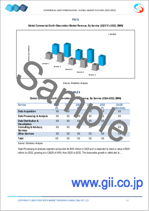
第6章 世界の商用地球観測市場:サービス別
- データ収集
- データ処理と分析
- データの配信と可視化
- コンサルティングおよびアドバイザリーサービス
- その他のサービス
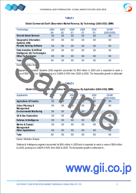
第7章 世界の商用地球観測市場:技術別
- 地上設置型センサー
- 地理情報システム(GIS)
- リモートセンシングソフトウェア
- データ分析と人工知能(AI)技術
- その他の技術
第8章 世界の商用地球観測市場:用途別
- 農業と林業
- 都市計画と管理
- 環境モニタリング
- 石油・ガス探査
- 防衛と諜報
- 海洋・沿岸管理
- その他の用途
第9章 世界の商用地球観測市場:エンドユーザー別
- 政府機関
- 環境団体
- 研究機関および学術機関
- 非政府組織(NGO)
- その他のエンドユーザー
第10章 世界の商用地球観測市場:地域別
- 北米
- 米国
- カナダ
- メキシコ
- 欧州
- ドイツ
- 英国
- イタリア
- フランス
- スペイン
- その他欧州
- アジア太平洋
- 日本
- 中国
- インド
- オーストラリア
- ニュージーランド
- 韓国
- その他アジア太平洋地域
- 南米
- アルゼンチン
- ブラジル
- チリ
- その他南米
- 中東・アフリカ
- サウジアラビア
- アラブ首長国連邦
- カタール
- 南アフリカ
- その他中東とアフリカ
第11章 主な発展
- 契約、パートナーシップ、コラボレーション、合弁事業
- 買収と合併
- 新製品発売
- 事業拡大
- その他の主要戦略
第12章 企業プロファイリング
- Planet Labs
- Maxar Technologies
- Airbus Defence and Space
- GeoIQ
- BlackSky Global
- Spire Global
- Satellogic
- ICEYE
- Ursa Space Systems
- Axiom Space
- Rocket Lab
- DigitalGlobe
- Capella Space
- Orbital Insight
List of Tables
- Table 1 Global Commercial Earth Observation Market Outlook, By Region (2022-2030) ($MN)
- Table 2 Global Commercial Earth Observation Market Outlook, By Data Type (2022-2030) ($MN)
- Table 3 Global Commercial Earth Observation Market Outlook, By Optical Imagery (2022-2030) ($MN)
- Table 4 Global Commercial Earth Observation Market Outlook, By Radar Imagery (2022-2030) ($MN)
- Table 5 Global Commercial Earth Observation Market Outlook, By Multispectral & Hyperspectral Imagery (2022-2030) ($MN)
- Table 6 Global Commercial Earth Observation Market Outlook, By Light Detection & Ranging (LiDAR) (2022-2030) ($MN)
- Table 7 Global Commercial Earth Observation Market Outlook, By Other Data Types (2022-2030) ($MN)
- Table 8 Global Commercial Earth Observation Market Outlook, By Service (2022-2030) ($MN)
- Table 9 Global Commercial Earth Observation Market Outlook, By Data Acquisition (2022-2030) ($MN)
- Table 10 Global Commercial Earth Observation Market Outlook, By Data Processing & Analysis (2022-2030) ($MN)
- Table 11 Global Commercial Earth Observation Market Outlook, By Data Distribution & Visualization (2022-2030) ($MN)
- Table 12 Global Commercial Earth Observation Market Outlook, By Consulting & Advisory Services (2022-2030) ($MN)
- Table 13 Global Commercial Earth Observation Market Outlook, By Other Services (2022-2030) ($MN)
- Table 14 Global Commercial Earth Observation Market Outlook, By Technology (2022-2030) ($MN)
- Table 15 Global Commercial Earth Observation Market Outlook, By Ground-based Sensors (2022-2030) ($MN)
- Table 16 Global Commercial Earth Observation Market Outlook, By Geographic Information Systems (GIS) (2022-2030) ($MN)
- Table 17 Global Commercial Earth Observation Market Outlook, By Remote Sensing Software (2022-2030) ($MN)
- Table 18 Global Commercial Earth Observation Market Outlook, By Data Analytics & Artificial Intelligence (AI) Technologies (2022-2030) ($MN)
- Table 19 Global Commercial Earth Observation Market Outlook, By Other Technologies (2022-2030) ($MN)
- Table 20 Global Commercial Earth Observation Market Outlook, By Application (2022-2030) ($MN)
- Table 21 Global Commercial Earth Observation Market Outlook, By Agriculture & Forestry (2022-2030) ($MN)
- Table 22 Global Commercial Earth Observation Market Outlook, By Urban Planning & Management (2022-2030) ($MN)
- Table 23 Global Commercial Earth Observation Market Outlook, By Environmental Monitoring (2022-2030) ($MN)
- Table 24 Global Commercial Earth Observation Market Outlook, By Oil & Gas Exploration (2022-2030) ($MN)
- Table 25 Global Commercial Earth Observation Market Outlook, By Defense & Intelligence (2022-2030) ($MN)
- Table 26 Global Commercial Earth Observation Market Outlook, By Marine & Coastal Management (2022-2030) ($MN)
- Table 27 Global Commercial Earth Observation Market Outlook, By Other Applications (2022-2030) ($MN)
- Table 28 Global Commercial Earth Observation Market Outlook, By End User (2022-2030) ($MN)
- Table 29 Global Commercial Earth Observation Market Outlook, By Government Agencies (2022-2030) ($MN)
- Table 30 Global Commercial Earth Observation Market Outlook, By Environmental Organizations (2022-2030) ($MN)
- Table 31 Global Commercial Earth Observation Market Outlook, By Research Institutions & Academia (2022-2030) ($MN)
- Table 32 Global Commercial Earth Observation Market Outlook, By Non-Governmental Organizations (NGOs) (2022-2030) ($MN)
- Table 33 Global Commercial Earth Observation Market Outlook, By Other End Users (2022-2030) ($MN)
Note: Tables for North America, Europe, APAC, South America, and Middle East & Africa Regions are also represented in the same manner as above.
According to Stratistics MRC, the Global Commercial Earth Observation Market is accounted for $5.16 billion in 2024 and is expected to reach $9.24 billion by 2030 growing at a CAGR of 10.2% during the forecast period. Commercial Earth Observation (EO) refers to the acquisition and analysis of satellite or aerial imagery and data for various commercial applications. This involves the use of remote sensing technology to monitor, assess, and manage resources, infrastructure, and the environment. By leveraging satellite data, businesses can gain insights into land use, environmental changes, and market trends, enhancing decision-making and operational efficiency across diverse industries.
According to the Indian Department of Space reports 2024, the Indian Space Research Organisation (ISRO) initiated the EOS-08 mission to integrate novel technologies into satellite systems.
Market Dynamics:
Driver:
Increasing demand for geospatial data
Industries such as agriculture, urban planning, and environmental management rely on EO data for insights into land use, resource allocation, and climate monitoring. As businesses seek to enhance decision-making and operational efficiency, the demand for accurate and timely geospatial information rises. Additionally, advancements in technology facilitate data accessibility and analysis, attracting investments and fostering collaborations between commercial providers and end-users. This trend strengthens the market's expansion and diversification of applications.
Restraint:
Data privacy concerns
Data privacy concerns in commercial earth observation arise from the sensitive nature of geospatial data, which can include information about individuals, infrastructure, and critical assets. Unauthorized access or misuse of this data poses risks to national security and personal privacy. These concerns can lead to regulatory scrutiny, limiting data availability and usage. As a result, these challenges can deter investment, slow down market growth, and create barriers to the adoption of EO technologies across various sectors.
Opportunity:
Urbanization and smart city initiatives
As urban areas expand, governments and planners require satellite imagery to monitor land use, manage infrastructure, and ensure sustainable development. EO technology aids in traffic management, environmental monitoring, and urban planning, enabling data-driven decision-making. Smart city projects leverage geospatial analytics for efficient resource allocation, improved public services, and enhanced quality of life. This trend fosters partnerships between commercial EO providers and city planners, further stimulating investments and innovation in the Earth observation sector.
Threat:
High initial investment
High initial investment in commercial earth observation stems from the significant costs associated with satellite development, launch, and maintenance, as well as the advanced technology required for data processing and analysis. This high cost structure hampers market growth by restricting access to cutting-edge EO technology, particularly for small and medium-sized enterprises, ultimately slowing down the adoption of EO solutions across various sectors.
Covid-19 Impact
The covid-19 pandemic significantly impacted the commercial earth observation market, initially causing disruptions in satellite launches and data collection due to lockdowns and restrictions. However, the demand for EO services surged as businesses and governments sought data for monitoring environmental changes, urban development, and resource management during the crisis. Increased reliance on remote sensing for supply chain management, agriculture, and disaster response highlighted the importance of EO technology, leading to accelerated investments and innovation within the sector post-pandemic.
The optical imagery segment is expected to be the largest during the forecast period
The optical imagery segment is predicted to secure the largest market share throughout the forecast period. Optical imagery is a key data type in commercial Earth observation, capturing high-resolution images of the Earth's surface using visible light. It provides detailed information for various applications, including agriculture, urban planning, and environmental monitoring. This data type supports decision-making processes by delivering timely insights into dynamic changes in the environment and infrastructure.
The defense & intelligence segment is expected to have the highest CAGR during the forecast period
The defense & intelligence segment is anticipated to witness the highest CAGR during the forecast period. Commercial earth observation plays a crucial role in defense and intelligence applications by providing high-resolution satellite imagery and geospatial data for strategic analysis and decision-making. This technology enables military and intelligence agencies to monitor enemy movements, assess geopolitical threats, and support mission planning. Additionally, it aids in disaster response and humanitarian missions by assessing damage and resource needs.
Region with largest share:
Asia Pacific is expected to register the largest market share during the forecast period driven by increasing demand for satellite imagery and geospatial analytics across various sectors. Countries like China, India, and Japan are at the forefront, leveraging EO technology for applications in agriculture, urban planning, and disaster management. The rise of smart city initiatives and environmental monitoring efforts further propels market growth. Additionally, advancements in satellite technology and fostering collaborations between government and private sectors are attracting investments in the region's burgeoning EO ecosystem.
Region with highest CAGR:
North America is projected to witness the highest CAGR over the forecast period driven by advanced satellite technology and a strong demand for geospatial data. The United States and Canada lead the market, driven by applications in agriculture, forestry, urban planning, and disaster response. Key players include established firms and innovative start-ups, focusing on high-resolution imagery and analytics. The region's emphasis on environmental monitoring and climate change adaptation further fuels the growth of the commercial EO market.
Key players in the market
Some of the key players profiled in the Commercial Earth Observation Market include Planet Labs, Maxar Technologies, Airbus Defence and Space, GeoIQ, BlackSky Global, Spire Global, Satellogic, ICEYE, Ursa Space Systems, Axiom Space, Rocket Lab, DigitalGlobe, Capella Space and Orbital Insight.
Key Developments:
In September 2024, Planet Labs PBC launched 12 SuperDoves aboard a SpaceX Falcon 9 rocket from Vandenberg Space Force Base in California. This mission aimed to bolster Planet's satellite fleet, enhancing its ability to capture high-resolution images of the Earth for various applications, including environmental monitoring and agriculture.
In August 2024, Rocket Lab launched a satellite for Japan's Synspective as part of their "Owl for One, Owl for All" mission. This mission delivered synthetic aperture radar (SAR) satellite designed to detect minute changes on the Earth's surface, supporting a constellation of such satellites for various Earth observation purposes.
Data Types Covered:
- Optical Imagery
- Radar Imagery
- Multispectral & Hyperspectral Imagery
- Light Detection & Ranging (LiDAR)
- Other Data Types
Services Covered:
- Data Acquisition
- Data Processing & Analysis
- Data Distribution & Visualization
- Consulting & Advisory Services
- Other Services
Technologies Covered:
- Ground-based Sensors
- Geographic Information Systems (GIS)
- Remote Sensing Software
- Data Analytics & Artificial Intelligence (AI) Technologies
- Other Technologies
Applications Covered:
- Agriculture & Forestry
- Urban Planning & Management
- Environmental Monitoring
- Oil & Gas Exploration
- Defense & Intelligence
- Marine & Coastal Management
- Other Applications
End Users Covered:
- Government Agencies
- Environmental Organizations
- Research Institutions & Academia
- Non-Governmental Organizations (NGOs)
- Other End Users
Regions Covered:
- North America
- US
- Canada
- Mexico
- Europe
- Germany
- UK
- Italy
- France
- Spain
- Rest of Europe
- Asia Pacific
- Japan
- China
- India
- Australia
- New Zealand
- South Korea
- Rest of Asia Pacific
- South America
- Argentina
- Brazil
- Chile
- Rest of South America
- Middle East & Africa
- Saudi Arabia
- UAE
- Qatar
- South Africa
- Rest of Middle East & Africa
What our report offers:
- Market share assessments for the regional and country-level segments
- Strategic recommendations for the new entrants
- Covers Market data for the years 2022, 2023, 2024, 2026, and 2030
- Market Trends (Drivers, Constraints, Opportunities, Threats, Challenges, Investment Opportunities, and recommendations)
- Strategic recommendations in key business segments based on the market estimations
- Competitive landscaping mapping the key common trends
- Company profiling with detailed strategies, financials, and recent developments
- Supply chain trends mapping the latest technological advancements
Free Customization Offerings:
All the customers of this report will be entitled to receive one of the following free customization options:
- Company Profiling
- Comprehensive profiling of additional market players (up to 3)
- SWOT Analysis of key players (up to 3)
- Regional Segmentation
- Market estimations, Forecasts and CAGR of any prominent country as per the client's interest (Note: Depends on feasibility check)
- Competitive Benchmarking
- Benchmarking of key players based on product portfolio, geographical presence, and strategic alliances
Table of Contents
1 Executive Summary
2 Preface
- 2.1 Abstract
- 2.2 Stake Holders
- 2.3 Research Scope
- 2.4 Research Methodology
- 2.4.1 Data Mining
- 2.4.2 Data Analysis
- 2.4.3 Data Validation
- 2.4.4 Research Approach
- 2.5 Research Sources
- 2.5.1 Primary Research Sources
- 2.5.2 Secondary Research Sources
- 2.5.3 Assumptions
3 Market Trend Analysis
- 3.1 Introduction
- 3.2 Drivers
- 3.3 Restraints
- 3.4 Opportunities
- 3.5 Threats
- 3.6 Technology Analysis
- 3.7 Application Analysis
- 3.8 End User Analysis
- 3.9 Emerging Markets
- 3.10 Impact of Covid-19
4 Porters Five Force Analysis
- 4.1 Bargaining power of suppliers
- 4.2 Bargaining power of buyers
- 4.3 Threat of substitutes
- 4.4 Threat of new entrants
- 4.5 Competitive rivalry
5 Global Commercial Earth Observation Market, By Data Type
- 5.1 Introduction
- 5.2 Optical Imagery
- 5.3 Radar Imagery
- 5.4 Multispectral & Hyperspectral Imagery
- 5.5 Light Detection & Ranging (LiDAR)
- 5.6 Other Data Types
6 Global Commercial Earth Observation Market, By Service
- 6.1 Introduction
- 6.2 Data Acquisition
- 6.3 Data Processing & Analysis
- 6.4 Data Distribution & Visualization
- 6.5 Consulting & Advisory Services
- 6.6 Other Services
7 Global Commercial Earth Observation Market, By Technology
- 7.1 Introduction
- 7.2 Ground-based Sensors
- 7.3 Geographic Information Systems (GIS)
- 7.4 Remote Sensing Software
- 7.5 Data Analytics & Artificial Intelligence (AI) Technologies
- 7.6 Other Technologies
8 Global Commercial Earth Observation Market, By Application
- 8.1 Introduction
- 8.2 Agriculture & Forestry
- 8.3 Urban Planning & Management
- 8.4 Environmental Monitoring
- 8.5 Oil & Gas Exploration
- 8.6 Defense & Intelligence
- 8.7 Marine & Coastal Management
- 8.8 Other Applications
9 Global Commercial Earth Observation Market, By End User
- 9.1 Introduction
- 9.2 Government Agencies
- 9.3 Environmental Organizations
- 9.4 Research Institutions & Academia
- 9.5 Non-Governmental Organizations (NGOs)
- 9.6 Other End Users
10 Global Commercial Earth Observation Market, By Geography
- 10.1 Introduction
- 10.2 North America
- 10.2.1 US
- 10.2.2 Canada
- 10.2.3 Mexico
- 10.3 Europe
- 10.3.1 Germany
- 10.3.2 UK
- 10.3.3 Italy
- 10.3.4 France
- 10.3.5 Spain
- 10.3.6 Rest of Europe
- 10.4 Asia Pacific
- 10.4.1 Japan
- 10.4.2 China
- 10.4.3 India
- 10.4.4 Australia
- 10.4.5 New Zealand
- 10.4.6 South Korea
- 10.4.7 Rest of Asia Pacific
- 10.5 South America
- 10.5.1 Argentina
- 10.5.2 Brazil
- 10.5.3 Chile
- 10.5.4 Rest of South America
- 10.6 Middle East & Africa
- 10.6.1 Saudi Arabia
- 10.6.2 UAE
- 10.6.3 Qatar
- 10.6.4 South Africa
- 10.6.5 Rest of Middle East & Africa
11 Key Developments
- 11.1 Agreements, Partnerships, Collaborations and Joint Ventures
- 11.2 Acquisitions & Mergers
- 11.3 New Product Launch
- 11.4 Expansions
- 11.5 Other Key Strategies
12 Company Profiling
- 12.1 Planet Labs
- 12.2 Maxar Technologies
- 12.3 Airbus Defence and Space
- 12.4 GeoIQ
- 12.5 BlackSky Global
- 12.6 Spire Global
- 12.7 Satellogic
- 12.8 ICEYE
- 12.9 Ursa Space Systems
- 12.10 Axiom Space
- 12.11 Rocket Lab
- 12.12 DigitalGlobe
- 12.13 Capella Space
- 12.14 Orbital Insight

