|
|
市場調査レポート
商品コード
1685966
衛星ベースの地球観測- 市場シェア分析、産業動向と統計、成長予測(2025年~2030年)Satellite-based Earth Observation - Market Share Analysis, Industry Trends & Statistics, Growth Forecasts (2025 - 2030) |
||||||
|
|||||||
カスタマイズ可能
適宜更新あり
|
|||||||
| 衛星ベースの地球観測- 市場シェア分析、産業動向と統計、成長予測(2025年~2030年) |
|
出版日: 2025年03月18日
発行: Mordor Intelligence
ページ情報: 英文 145 Pages
納期: 2~3営業日
|

全表示
- 概要
- 目次
衛星ベースの地球観測市場規模は、2025年に43億米ドルと推定され、予測期間中(2025年~2030年)のCAGRは6.52%で、2030年には59億米ドルに達すると予測されています。
衛星を利用した地球観測は、リモートセンシングを利用して地球の様々な問題に関連する情報を収集するプロセスです。人間の生活や環境に影響を与える様々な用途で利用されています。宇宙技術は、開発課題の解決に役立つ重要な情報を提供します。地球観測衛星は宇宙からデータを収集し、地球の自然環境と人工環境、その地域が時間とともにどのように変化するか、これらの変化を緩和するために政策立案者に何ができるかについて、貴重な洞察を提供しています。これらのデータは、開発、援助、救済に携わる機関や組織によって利用されています。
主なハイライト
- 欧州委員会は最近、世界の森林破壊に取り組むことを目的とした法律を導入しました。その結果、森林破壊に関連する商品を販売する事業者は、義務的なデューデリジェンスを実施することが求められるようになりました。企業は、森林破壊のない商品のみがEU市場で販売されるよう、商品が生産される土地に関する地理的情報を入手しなければならないです。この開発により、サプライチェーン追跡のための衛星データへの需要が高まり、市場の成長に寄与しています。
- 広大な土地の効率的なモニタリングに対する需要の高まりが、衛星ベースの地球観測市場の成長を後押ししています。この急増は、天然資源、都市開発、農業活動、環境変化、安全保障上の懸念を世界規模で管理・観測する必要性に起因しています。
- スマートシティへの取り組みが衛星ベースの地球観測技術への需要を牽引しています。こうした取り組みでは、都市計画、インフラ管理、環境モニタリング、災害対応など、さまざまな目的で衛星データが活用されます。スマートシティが効率性と持続可能性を追求する中、衛星ベースの地球観測は、情報に基づいた意思決定と効果的な資源配分のためのリアルタイムのデータと洞察を提供します。その結果、世界中でスマートシティ構想の採用が増加していることが、衛星ベースの地球観測市場の成長に拍車をかけています。
- オープンソースデータは多くの場合自由に利用できるため、独占的な衛星データを購入するのに比べ、企業や研究者の参入障壁が低くなります。オープンソースのデータは、より幅広いユーザーが利用できるため、農業、都市計画、環境モニタリングなどの分野で、より大きなイノベーションとアプリケーションの開発が可能になります。
- 不況時には、政府はしばしば予算を引き締め、裁量的支出の削減につながります。このことは、地球観測データの主要な消費者である宇宙プログラムや環境モニタリングイニシアティブへの投資に影響を与える可能性があります。不況は経済的な不確実性をもたらし、企業が投資に対してより慎重になる原因となります。そのため、企業は衛星画像や関連サービスに対する支出を先延ばしまたは削減する可能性があります。特に、認識される価値提案が当面の財務的懸念に直接対処する必要がある場合はなおさらです。
衛星ベースの地球観測市場の動向
都市開発が最も急成長するアプリケーションに
- 都市開発における新興企業を支援する政府の取り組みが、市場開拓の成長を促進すると思われます。例えば、2023年12月、インド宇宙省の結節機関は、国立リモートセンシングセンターと共同で、宇宙技術を利用した都市開発や災害管理で活動する新興企業を支援するシードファンド制度を開始しました。
- 資金援助を受けた新興企業は、都市計画や開発のためにEOデータの応用を開発することが期待されています。これにより、都市開発における重要な課題に対応する新たなサービスが生まれる可能性があります。さらに、EOベースのソリューションを持つ新興企業の増加は、利用可能なサービスの幅を広げると予想されます。
- 都市人口の急増に伴う都市開発への投資の拡大は、市場の成長を支えるインフラ施設の必要性を生み出しています。人口問題研究所によると、2023年の世界の都市化率は57%です。北米、ラテンアメリカ、カリブ海諸国が最も都市化の進んだ地域で、人口の5分の4以上が都市部に居住しています。
- 2022年、米国住宅都市開発省は約293億1,000万米ドルを支出すると報告しました。米国行政管理予算局の予測では、この数字は2028年までに約802億6,000万米ドルに増加すると予想されています。
- 最近、高解像度の衛星画像を提供するベンダーであるSatellogic社は、GeoterraImage社と共同で、完全自動の建物開拓検知・監視システムを南アフリカ市場に導入しました。このシステムは、南アフリカの自治体や州政府向けに、新規開発の監視とマッピングのための効率的で費用対効果の高いソリューションを提供します。
北米が大きな市場シェアを占める
- 北米では、高解像度データを求める農業、環境、防衛などの部門に牽引され、衛星ベースの地球観測の需要が急増しています。衛星画像は、北米の広大な遠隔地の環境問題を監視する上で重要な役割を果たしています。たとえば、アメリカ海洋大気庁(NOAA)の衛星は、毎週オゾンレベルを分析し、氷山の動きを追跡し、山火事や雷雨などの事象に関するデータを提供しています。こうした情報は、持続可能な資源管理のためのデータ主導の政策立案に役立ちます。
- 国防軍が反乱戦術や仮想戦争を含む進化する脅威に直面する中、インテリジェンス収集は地上での作戦と同様に不可欠となっています。地理空間ツールは、国防軍に潜在的な危険に対する計画、監視、対抗の力を与えます。
- 北米地域では防衛分野への投資が増加しており、市場関係者にチャンスをもたらしています。2024年度、米国国防総省(DOD)は261億米ドルの予算を要求し、2023年度要求から44億米ドルの増加を示しました。さらに、インドと米国は2023年11月、NASA-ISRO合成開口レーダー(NISAR)と名付けられた共同マイクロ波リモートセンシング衛星を2024年初めに打ち上げる計画を発表しました。
- 北米で衛星画像の需要を牽引しているのは都市開発です。高解像度の衛星画像は、道路網、インフラ、土地被覆の変化など、都市部の詳細な評価を可能にします。この需要に対応するため、地域の企業は衛星画像プログラムを立ち上げています。
- 例えば、2024年3月、Vexcel Data Programは、米国での年間航空画像収集を拡大し、下位48州の440万km四方をカバーするようになりました。これは、前年に比べ15%カバー範囲が拡大したことを意味し、詳細な7.5cmの解像度で都市部に重点を置いています。主要都市や都市部は、年間3回まで撮影される予定です。
- 衛星画像市場は、特に環境や防衛などの分野で、分野横断的な重要性の高まりと政府投資の増加により、顕著な盛り上がりを見せています。
衛星ベースの地球観測産業の概要
衛星ベースの地球観測市場は著しく断片化されており、世界企業と中小企業が混在しています。主な企業としては、Airbus Defence and Space(Airbus SE)、Esri Inc.、Imagesat International(ISI)Ltd.、MDA Corporation(Maxar Technologies)、Planet Labs PBCなどが挙げられます。市場企業は、製品ラインを改善し、持続的な競争優位性を確保するために、パートナーシップや買収などの戦略を採用しています。
2024年3月-Ursa Space Systems Inc.は、防衛知能分野に特化した英国の中小企業であるMAIARと提携し、NATOの地理空間分析とオープンソース分析を強化し、英国の作戦ユーザーの利益に焦点を当てる。この協業は、MAIARのミッションの複雑さに対する深い理解とUrsaの高度な分析プラットフォームを活用し、地理空間分析への迅速かつインパクトのあるアプローチを提供します。両社の協力により、納期を短縮し、成果を最大化することで、英国とNATOの双方の顧客の価値を向上させることができます。
2024年1月-イメージサット・インターナショナル(ISI)は、未公表の戦略的顧客に衛星サービスを5年間提供する総額約3,750万米ドルの契約を獲得したと発表しました。この契約では、ISIはEROS C2衛星とEROS C3衛星、メンテナンス、地上局サービスを通じて30cm解像度の画像サービスを顧客に提供します。
その他の特典:
- エクセル形式の市場予測(ME)シート
- 3ヶ月間のアナリスト・サポート
目次
第1章 イントロダクション
- 調査の前提条件と市場定義
- 調査範囲
第2章 調査手法
第3章 エグゼクティブサマリー
第4章 市場洞察
- 市場概要
- 業界の魅力度-ポーターのファイブフォース分析
- 供給企業の交渉力
- 買い手/消費者の交渉力
- 新規参入業者の脅威
- 代替品の脅威
- 競争企業間の敵対関係
- マクロ経済シナリオの分析(景気後退、ロシア・ウクライナ戦争危機など)
第5章 市場力学
- 市場促進要因
- 広大な国土を効率的に監視する必要性の高まり
- スマートシティ構想の高まり
- ビッグデータと画像解析
- 市場抑制要因
- 各国のオープンソースデータの入手可能性
- 地球観測の主な使用事例の分析
- 交通インフラのインテリジェンス
- 災害リスク評価
- 河川流域の洪水管理
- 都市環境と気候変動への適応
- 水力発電開発
- 価格と価格モデルの分析
- エコシステム分析
- 地理空間画像分析の概要と関連する成長動向
第6章 市場セグメンテーション
- サービス別
- データ
- 付加価値サービス
- 技術別
- 合成開口レーダー(SAR)
- 光学式
- 用途別
- 都市開発
- 農業
- 気候・環境サービス
- エネルギー
- インフラ監視
- 災害・緊急管理
- その他の用途
- 地域別
- 北米
- 欧州
- アジア太平洋
- 中東・アフリカ
- ラテンアメリカ
第7章 競合情勢
- 企業プロファイル
- Airbus Defence and Space(Airbus SE)
- ESRI INC.
- IMAGESAT International(I.S.I)LTD
- MDA Corporation(Maxar Technologies)
- PLANET LABS PBC
- PlanetIQ LLC
- EOS Data Analytics Inc.
- L3harris Technologies Inc.
- ICEYE
- BLACKSKY TECHNOLOGY INC.
- Capella Space
- Ursa Space Systems Inc.
- Descartes Lab
- Orbital Insight
- Spacceknow Inc.
第8章 投資分析
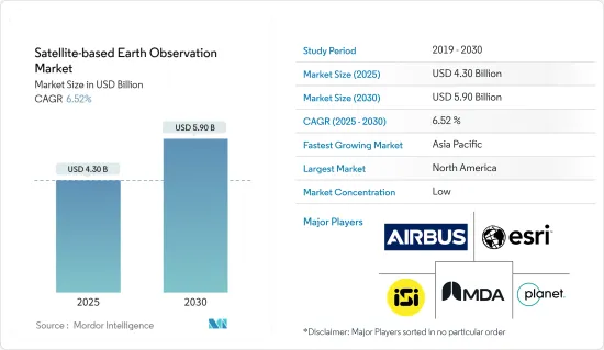
The Satellite-based Earth Observation Market size is estimated at USD 4.30 billion in 2025, and is expected to reach USD 5.90 billion by 2030, at a CAGR of 6.52% during the forecast period (2025-2030).
Satellite-based earth observation is a process of collecting information related to the Earth's various issues using remote sensing. It is used in various applications that impact human life and the environment. Space technology offers vital information that helps address development challenges. Earth observation satellites have been collecting data from space, providing valuable insights into the Earth's natural and artificial environment, how its regions change over time, and what policy-makers can do to mitigate these changes. This data is used by agencies and institutions working in development, aid, and relief.
Key Highlights
- The European Commission has recently introduced legislation aimed at tackling global deforestation. As a result, operators who sell deforestation-related commodities are now required to conduct mandatory due diligence. Companies must obtain geographical information about the land where their products are produced to ensure that only deforestation-free goods are sold in the EU market. This development has led to increased demand for satellite data for supply chain tracking, contributing to the market's growth.
- The increasing demand for efficient monitoring of vast land areas is indeed driving the growth of the satellite-based Earth observation market. This surge is attributable to the need to manage and observe natural resources, urban development, agricultural activities, environmental changes, and security concerns on a global scale.
- Smart city initiatives are driving the demand for satellite-based Earth observation technology. These initiatives utilize satellite data for various purposes like urban planning, infrastructure management, environmental monitoring, and disaster response. As smart cities strive for efficiency and sustainability, satellite-based Earth observation provides real-time data and insights for informed decision-making and effective resource allocation. Consequently, the increasing adoption of smart city initiatives worldwide is fueling the growth of the satellite-based Earth observation market.
- Open-source data is often freely available, reducing the barrier to entry for businesses and researchers compared to purchasing proprietary satellite data. The open-source data is more accessible to a wider range of users, enabling greater innovation and development of applications in areas such as agriculture, urban planning, and environmental monitoring.
- During recessions, governments often tighten their budgets, leading to cuts in discretionary spending. This may impact investments in space programs and environmental monitoring initiatives, which are major consumers of Earth observation data. Recession creates economic uncertainty, causing businesses to become more cautious with their investments. Thus, companies might postpone or reduce their spending on satellite imagery and related services, especially when the perceived value proposition needs to address immediate financial concerns directly.
Satellite-based Earth Observation Market Trends
Urban Development to be the Fastest Growing Application
- The government initiatives to support new startups in urban development are likely to drive market growth. For instance, in December 2023, the Indian nodal agency in the Department of Space, in collaboration with the National Remote Sensing Center, launched a seed fund scheme to support startups operating in urban development and disaster management using space technology.
- With financial assistance, the startups are expected to develop applications of EO data for urban planning and development. This could lead to the creation of new services that address critical challenges in urban development. Further, the growth in the number of startups with EO-based solutions is expected to broaden the range of services available.
- The growing investment in urban development due to the rapidly growing urban population creates the need for infrastructure facilities that support market growth. According to the Population Reference Bureau, in 2023, the degree of urbanization globally was 57 percent. North America, Latin America, and the Caribbean were the regions with the highest level of urbanization, with over four-fifths of the population residing in urban areas.
- In 2022, the US Department of Housing and Urban Development reported spending around USD 29.31 billion. Projections from the US Office of Management and Budget anticipate this figure will rise to approximately USD 80.26 billion by 2028.
- Recently, the market vendor Satellogic, a high-resolution satellite imagery provider, collaborated with GeoterraImage to introduce a fully automated building development detection and monitoring system to the South African market. This system offers an efficient and cost-effective solution for monitoring and mapping new developments for municipalities and provincial governments in South Africa.
North America to Hold Significant Market Share
- North America is experiencing a surge in demand for satellite-based Earth observation, driven by sectors like agriculture, environment, and defense seeking high-resolution data. Satellite imagery plays a crucial role in monitoring environmental issues across North America's vast and remote landscapes. For instance, the National Oceanic and Atmospheric Administration (NOAA) satellites provide weekly analysis of ozone levels, track iceberg movements, and offer data on events like bushfires and thunderstorms. Such information aids in formulating data-driven policies for sustainable resource management.
- As defense forces face evolving threats, including insurgency tactics and virtual warfare, intelligence gathering becomes as vital as on-the-ground operations. Geospatial tools empower defense forces to plan, monitor, and counter potential dangers.
- The North American region is witnessing increased investments in its defense sector, presenting opportunities for market players. In FY2024, the US Department of Defense (DOD) requested a budget of USD 26.1 billion, marking a USD 4.4 billion increase from its FY2023 request. Additionally, in November 2023, India and the United States announced plans to launch a joint microwave remote sensing satellite, named NASA-ISRO Synthetic Aperture Radar (NISAR), in early 2024.
- Urban development is a prominent application driving the demand for satellite imagery in North America. High-resolution satellite images enable detailed assessments of urban areas, including road networks, infrastructure, and land cover changes. In response to this demand, regional players are launching satellite imagery programs.
- For instance, in March 2024, the Vexcel Data Program expanded its annual aerial imagery collection in the US, covering 4.4 million km square in the Lower 48 states. This represents a 15% increase in coverage compared to the previous year, with a focus on urban areas at a detailed 7.5 cm resolution. Major cities and urban areas will be imaged up to 3 times annually.
- The satellite imagery market is witnessing a notable uptick, driven by its growing importance across sectors and increased government investments, particularly in areas like environment and defense.
Satellite-based Earth Observation Industry Overview
The market for satellite-based earth observation is significantly fragmented, featuring a mix of global corporations and small to medium-sized businesses.Some of the major players are Airbus Defence and Space (Airbus SE), Esri Inc., Imagesat International (ISI) Ltd, MDA Corporation (Maxar Technologies), and Planet Labs PBC. Market players are employing strategies like partnerships and acquisitions to improve their product lines and secure a lasting competitive advantage.
March 2024 - Ursa Space Systems Inc. partnered with MAIAR, a UK small business specializing in the Defence Intelligence arena, to augment geospatial and open-source analytics for NATO, focusing on benefitting the United Kingdom's operational users. This collaboration leverages MAIAR's deep understanding of mission intricacies and Ursa's advanced analytics platform, providing a swift and impactful approach to geospatial analytics. Together, the two companies are poised to expedite delivery times and maximize the magnitude of results, ensuring improved value for both UK and NATO customers.
January 2024 - Imagesat International (ISI) stated that it was awarded a contract worth a total sum of around USD 37.5M for the provision of satellite services to an undisclosed strategic customer during a period of 5 years. Under this contract, ISI would deliver the customer 30 cm resolution imaging services through its EROS C2 and EROS C3 satellites and maintenance and ground station services.
Additional Benefits:
- The market estimate (ME) sheet in Excel format
- 3 months of analyst support
TABLE OF CONTENTS
1 INTRODUCTION
- 1.1 Study Assumptions and Market Definition
- 1.2 Scope of the Study
2 RESEARCH METHODOLOGY
3 EXECUTIVE SUMMARY
4 MARKET INSIGHTS
- 4.1 Market Overview
- 4.2 Industry Attractiveness - Porter's Five Forces Analysis
- 4.2.1 Bargaining Power of Suppliers
- 4.2.2 Bargaining Power of Buyers/Consumers
- 4.2.3 Threat of New Entrants
- 4.2.4 Threat of Substitute Products
- 4.2.5 Intensity of Competitive Rivalry
- 4.3 Analysis of Macro-economic Scenarios (Recession, Russia-Ukraine War Crisis, Etc.)
5 MARKET DYNAMICS
- 5.1 Market Drivers
- 5.1.1 Increasing Requirement for Efficient Monitoring of Vast Land Areas
- 5.1.2 Rising Smart City Initiatives
- 5.1.3 Big Data and Imagery Analytics
- 5.2 Market Restraints
- 5.2.1 Availability of Open-source Data for Various Countries
- 5.3 Analysis of Key Use Cases of Earth Observation
- 5.3.1 Transport Infrastructure Intelligence
- 5.3.2 Disaster Risk Assessment
- 5.3.3 River Basin Flood Management
- 5.3.4 Urban Environment and Climate Change Adaptation
- 5.3.5 Hydropower Development
- 5.3.6 Analysis of Pricing and Pricing Model
- 5.3.7 Ecosystem Analysis
- 5.3.8 Overview of Geospatial Imagery Analytics and Associated Growth Trends
6 MARKET SEGMENTATION
- 6.1 By Service
- 6.1.1 Data
- 6.1.2 Value-Added-Service
- 6.2 By Technology
- 6.2.1 Synthetic Aperture Radar (SAR)
- 6.2.2 Optical
- 6.3 By Application
- 6.3.1 Urban Development (Includes Public Safety)
- 6.3.2 Agriculture
- 6.3.3 Climate and Environment Services
- 6.3.4 Energy
- 6.3.5 Infrastructure Monitoring
- 6.3.6 Disaster and Emergency Management
- 6.3.7 Other Applications
- 6.4 By Geography
- 6.4.1 North America
- 6.4.2 Europe
- 6.4.3 Asia-Pacific
- 6.4.4 Middle East and Africa
- 6.4.5 Latin America
7 COMPETITIVE LANDSCAPE
- 7.1 Company Profiles
- 7.1.1 Airbus Defence and Space (Airbus SE)
- 7.1.2 ESRI INC.
- 7.1.3 IMAGESAT International (I.S.I) LTD
- 7.1.4 MDA Corporation (Maxar Technologies)
- 7.1.5 PLANET LABS PBC
- 7.1.6 PlanetIQ LLC
- 7.1.7 EOS Data Analytics Inc.
- 7.1.8 L3harris Technologies Inc.
- 7.1.9 ICEYE
- 7.1.10 BLACKSKY TECHNOLOGY INC.
- 7.1.11 Capella Space
- 7.1.12 Ursa Space Systems Inc.
- 7.1.13 Descartes Lab
- 7.1.14 Orbital Insight
- 7.1.15 Spacceknow Inc.
