
|
市場調査レポート
商品コード
1549968
英国の地理空間画像分析:市場シェア分析、産業動向・統計、成長予測(2024年~2029年)United Kingdom Geospatial Imagery Analytics - Market Share Analysis, Industry Trends & Statistics, Growth Forecasts (2024 - 2029) |
||||||
カスタマイズ可能
適宜更新あり
|
|||||||
| 英国の地理空間画像分析:市場シェア分析、産業動向・統計、成長予測(2024年~2029年) |
|
出版日: 2024年09月02日
発行: Mordor Intelligence
ページ情報: 英文 100 Pages
納期: 2~3営業日
|

全表示
- 概要
- 目次
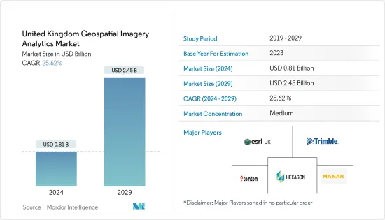
英国の地理空間画像分析の市場規模は2024年に8億1,000万米ドルと推定され、2029年には24億5,000万米ドルに達すると予測され、予測期間(2024-2029年)のCAGRは25.62%で成長すると予測されます。
主なハイライト
- 空間データの可視化により、気象モデリング、人口予測、販売動向などを把握するためのデータ取得に使用される地理空間解析の需要が、地理空間画像解析の商業化に拍車をかけており、英国市場の成長を支えています。
- 同国の農業分野やその他のエンドユーザー産業の発展において、環境土地管理計画をサポートすることで空間解像度のセンシングや画像データ分析が応用されていることが、同市場の成長を後押ししています。例えば、2023年9月、英国の地理空間インテリジェンス企業であるEarth-i社は、地球観測データを利用して、企業、政府、その他の組織に意思決定の利点をもたらす地理空間データから得られる洞察を提供しました。同社は、Planet Labsの地球画像衛星群を通じて環境モニタリングを提供する重要な複数年契約を獲得しており、同国における地理空間画像分析ソリューションの需要を示しています。
- 地理空間データは、同国の都市計画において、プランナーやデベロッパーが社会インフラ、施設、コミュニティスペースを特定するのにますます利用されるようになっています。例えば、IBMは2023年11月、NASAと共同で開発したIBMの地理空間基盤モデルを含む地理空間AI技術を、英国における気候回復力を含む気候への取り組みに適用する計画であると発表しました。これは、同国の都市計画における地理空間画像分析の重要性が高まっていることを示しており、今後の市場成長を後押しするものです。
- 英国では、地理空間データに関連するデータプライバシー侵害リスクや、国家安全保障への影響が、地理空間画像分析市場の導入に大きな市場抑制要因となっています。企業の防衛や重要インフラ事業を含む大規模組織は、地理空間データに対する要求が高いです。しかし、地政学的な不利なシナリオの増加やサイバー攻撃の増加の情勢に伴い、データの安全性やそれに伴う地理空間データのハッキングのリスクに対する懸念が、予測期間中の市場の成長を制限しています。
- COVID-19パンデミックは、英国の地理空間画像解析市場の成長を支えました。地理空間画像解析は、ウイルスの拡散追跡、高リスク地域の特定、封じ込め対策の効果評価に役立ち、緊急事態への対応におけるリモートセンシングと地理空間データの価値を高めました。こうした要因が、パンデミック後の市場を押し上げました。
英国の地理空間画像分析市場の動向
環境安全と持続可能な発展を目指した都市計画が市場成長を牽引
- 英国の都市部における雇用機会の増加や、国内外からの移住者の増加に支えられた都市人口の増加が、同国における都市計画の需要に拍車をかけており、英国における地理空間画像解析ソリューションの成長機会を生み出しています。
- 地理空間解析は、エネルギー、交通、住宅資源に対する人口増加の影響を判断するのに役立ちます。プランナーは、地理空間ビッグデータ解析によって大規模なデータセットをスピードとスケールで可視化し、同国の犯罪を減らし、公衆衛生、教育、住宅/不動産のための都市開発を拡大することができ、予測期間中の市場成長を支えています。
- 2023年1月、ナチュラル・イングランドは、質の高い、自然豊かで気候変動に強い都市緑地の設計と創出において、地方計画当局と開発業者を支援する包括的なツールであるグリーン・インフラストラクチャー・フレームワークを発表しました。これは、全国で緑地への公平なアクセスを支援するもので、その地方で緑地を開発する目標を掲げており、この国の都市化の景観において、持続可能な開発プロジェクトの重要性が高まっていることを示しています。
- 国内の都市部では、不浸透面(道路、舗装、屋根など)の割合が高く、従来の排水システムが降雨量に対応するように設計されていないため、洪水や崩壊のリスクが高まっています。このシナリオは、都市開発プロジェクトにおける排水システムの設計に適用されるため、同国における地理空間画像解析ソリューションの需要を高めると思われます。
- 英国政府の経済成長目標は、環境保護と気候変動への適応を確保しつつ、市場の成長を支えています。例えば、2024年4月、英国地理空間委員会は、アラン・チューリング研究所と提携し、同国の都市における土地の利用方法に関する長期的な意思決定におけるAIの機会を探っており、環境の安全性と持続可能な開発のための都市計画に沿った英国における市場の将来的な成長の可能性を示しています。
環境モニタリング分野が市場シェアに大きく貢献
- 米国では、環境の状態や経年変化をモニタリングすることの重要性に対する認識が高まり、環境モニタリングの需要が高まっています。このため、環境要因に関するリアルタイムの画像や映像データを提供する地理空間画像解析の需要が高まり、英国市場の成長を後押ししています。
- さらに、同国では衛星画像やリモートセンシングを利用した環境モニタリングや保全イニシアチブの導入が増加しており、衛星データを活用することで、GISの専門家は植生、土地被覆、水域の変化を監視することができ、生物多様性のモニタリングや森林伐採の影響、生態系の劣化が起こりやすい場所の評価に役立っています。
- さらに2024年1月、イノベーティブ・UKと環境食糧農村地域省(Defra)は、環境変数のモニタリング向上を可能にする環境モニタリング・ソリューションを開発するための共同プロジェクトに500万英ポンドを投資することを計画しています。これにより、環境モニタリングプロジェクトにおける技術統合の需要が高まり、予測期間中、英国の市場ベンダーのビジネス成長機会が促進されるであろう。
- 英国の建設業界は、建設プロジェクトが環境に与える影響を含む第61条を遵守しなければならないです。この規制は、環境モニタリングのための大気質、騒音モニタリング、振動の追跡需要を高め、規制遵守と持続可能で責任あるプロジェクトの完了を保証するのに役立っており、同国における環境モニタリングの需要を示しています。
- 国の天候、住民、その他の環境要因を管理するために地理空間分析を採用する政府の戦略は、市場の成長を支えています。例えば、2023年4月、英国地理空間委員会は、環境モニタリングを含む公共サービスにおける地球観測データ利用のためのパイロットプログラムを開始し、同国における分析および環境政策管理のための地理空間データの重要性を示しています。こうした要因が、今後の市場成長を後押しする可能性があります。
英国の地理空間画像分析産業の概要
英国の地理空間画像分析市場は、多くのローカルおよび多国籍ソリューションプロバイダーで構成されており、市場は適度に断片化されています。同市場は、パートナーシップやコラボレーションを通じたエンドユーザーとの契約更新に支えられ、市場ベンダーによるポートフォリオ拡張のための活発な投資を記録しており、各社が同国での市場プレゼンスを高めるのに役立っています。
- 2023年8月、英国の気象庁は、地理空間画像解析を含むESRI UKの地理空間技術をベースに構築された新しい気候ポータルの立ち上げを発表し、同国の政府、保険、交通、エネルギー、土地利用、都市計画、ヘルスケアなどの組織が利用できるようになった。このようなベンダーと政府機関との連携は、同社の市場での存在感を高めることになります。
その他の特典:
- エクセル形式の市場予測(ME)シート
- 3ヶ月間のアナリスト・サポート
目次
第1章 イントロダクション
- 調査の前提条件と市場定義
- 調査範囲
第2章 調査手法
第3章 エグゼクティブサマリー
第4章 市場洞察
- 市場概要
- 業界の魅力度-ポーターのファイブフォース分析
- 買い手の交渉力
- 供給企業の交渉力
- 新規参入業者の脅威
- 代替品の脅威
- 競争企業間の敵対関係
- 業界バリューチェーン分析
- COVID-19の市場への影響評価
第5章 市場力学
- 市場促進要因
- エンドユーザー全体でのデータ分析ソリューション利用の進展
- 環境安全性と持続可能な開発のための国内都市計画の成長
- 市場抑制要因
- 高コストと運用上の懸念
- ジオプライバシーと機密データに関する懸念
第6章 市場セグメンテーション
- タイプ別
- 画像解析
- ビデオ分析
- 展開モード別
- オンプレミス
- クラウド
- 組織規模別
- 中小企業
- 大企業
- 業界別
- 保険
- 農業
- 防衛・セキュリティ
- 環境モニタリング
- エンジニアリングと建設
- 政府機関
- その他
第7章 競合情勢
- 企業プロファイル
- Hexagon AB
- ESRI(UK)Limited
- TomTom International BV
- Trimble Inc.
- L3Harris Technologies Inc.
- Maxar Technologies
- Google LLC
- Microsoft Corporation
- Bluesky International Ltd
- Oracle Corporation
第8章 投資分析
第9章 市場機会と今後の動向
The United Kingdom Geospatial Imagery Analytics Market size is estimated at USD 0.81 billion in 2024, and is expected to reach USD 2.45 billion by 2029, growing at a CAGR of 25.62% during the forecast period (2024-2029).
Key Highlights
- The demand for geospatial analysis used for data capture to understand weather modeling, population forecasting, and sales trends by visualization of spatial data is fueling the commercialization of geospatial imagery analytics, supporting the market growth in the United Kingdom.
- The application of spatial resolution sensing and imagery data analytics in developing the country's agriculture sector and other end-user industries by supporting its Environmental Land Management scheme is fueling the growth of the market. For instance, in September 2023, Earth-i, a UK-based geospatial intelligence company, used Earth observation data to provide insights derived from geospatial data that deliver decision advantages for businesses, governments, and other organizations. It was awarded a significant multi-year contract to provide environmental monitoring through Planet Labs' fleet of earth imaging satellites, showing the demand for geospatial imagery analytics solutions in the country.
- Geospatial data is increasingly used to help planners and developers identify social infrastructure, facilities, and community spaces in the country's city planning. For instance, in November 2023, IBM announced that it planned to apply its geospatial AI technologies, including IBM's geospatial foundation model developed in collaboration with NASA, to climate efforts, including climate resiliency in the United Kingdom. This shows the increasing importance of geospatial imagery analytics in urban planning in the country, supporting future market growth.
- The data privacy breaching risks related to the geospatial data and their impact on national security in the United Kingdom are creating a significant market restraint for adopting the geospatial imagery analytics market. Large-scale organizations, including companies' defense and critical infrastructure businesses, have high requirements for geospatial data. However, the concern for data security and the associated risk of geo-data hacking is in line with the growth of adverse geopolitical scenarios and the increasing landscape of cyber attacks, restricting the market growth during the forecast period.
- The COVID-19 pandemic supported the growth of the geospatial imagery analytics market in the United Kingdom. Geospatial imagery analytics helped track the spread of the virus, identify high-risk areas, and evaluate the effectiveness of containment measures, which raised the value of remote sensing and geospatial data in responding to emergencies. These factors helped boost the market over the post-pandemic period.
United Kingdom Geospatial Imagery Analytics Market Trends
Urban Planning in the Country for Environment Safety and Sustainable Development Drives Market Growth
- The growth of the urban population in the country, supported by the increasing job opportunities in the cities of the United Kingdom and the growth of domestic and international migrants, is fueling the demand for urban planning in the country, creating an opportunity for the geospatial imagery analytics solutions in the United Kingdom.
- Geospatial analytics aids in determining the effect of the growing population on energy, transportation, and housing resources. Planners can visualize large datasets at the speed and scale with geospatial big data analytics to reduce crime and increase urban development for public health, education, and housing/real estate in the country, supporting the market growth during the forecast period.
- In January 2023, Natural England published the Green Infrastructure Framework, a comprehensive tool to support local planning authorities and developers in designing and creating quality, nature-rich, climate-resilient urban greenspaces. It supports equitable access to greenspace across the country, with a target for developing greenspace in its local area, showing the increasing importance of sustainable development projects in the urbanization landscape of the country.
- The risk of flooding and disruption in urban areas of the country is increasing due to the high proportion of impervious surfaces (roads, paving, roofs, etc.) and a traditional drainage system not designed to accommodate the volume of rainfall. This scenario would raise the demand for geospatial imagery analytics solutions in the country due to their application in designing drainage systems in urban development projects.
- The UK government's economic growth target supports the market's growth while ensuring the protection of the environment and adapting to climate change. For instance, in April 2024, the Geospatial Commission of the United Kingdom partnered with the Alan Turing Institute to explore the opportunity of AI in long-term decisions about how to use land in the cities of the country, showing the future growth potential of the market in the United Kingdom in line with urban planning for environment safety and sustainable development.
The Environmental Monitoring Segment Contributes Significantly to the Market Share
- The demand for environmental monitoring is rising in the United Kingdom with the rise in awareness regarding the importance of monitoring the environment's state and changes over time. This is driving the demand for geospatial imagery analytics due to its application in providing real-time imagery and video data about environmental factors, fueling market growth in the United Kingdom.
- Additionally, with the increasing adoption of environmental monitoring and conservation initiatives in the country through satellite imaging and remote sensing, leveraging satellite data, GIS professionals can monitor changes in vegetation, land cover, and water bodies, which helps monitor biodiversity and evaluate the effects of deforestation and locations vulnerable to ecological degradation.
- Furthermore, in January 2024, Innovative UK and the Department for Environment Food Rural Affairs (Defra) planned to invest GBP 5 million in collaborative projects to develop environmental monitoring solutions to enable improved monitoring of environmental variables. This would fuel the demand for technology integrations in the environmental monitoring project and drive business growth opportunities for market vendors in the United Kingdom during the forecast period.
- The UK construction industry must comply with Section 61, which includes the impact of construction projects on the environment. The regulation helps raise the demand for tracking air quality, noise monitoring, and vibration for environmental monitoring, ensuring regulatory compliance and sustainable and responsible completion of projects, which shows the demand for environmental monitoring in the country.
- The governmental strategy for adopting geospatial analytics to manage the country's weather, inhabitants, and other environmental factors supports market growth. For instance, in April 2023, the UK Geospatial Commission launched a pilot program for the use of Earth observation data in public services, including environmental monitoring, showing the importance of geospatial data for analytics and managing the environmental policies in the country. These factors may fuel the market growth in the future.
United Kingdom Geospatial Imagery Analytics Industry Overview
The UK geospatial imagery analytics market consists of many local and multi-national solution providers, making the market moderately fragmented. The market has been registering active investments by the market vendors for portfolio expansions, supported by the renewal of contracts with the end users through partnerships and collaborations, helping the companies to increase their market presence in the country.
- In August 2023, the United Kingdom's Met Office announced the launch of its new climate portal, built on geospatial technology from ESRI UK, including its geospatial imagery analytics, which organizations within government, insurance, transportation, energy, land use, urban planning, and healthcare in the country can use. This collaboration of market vendors with governmental organizations would support the company's market presence.
Additional Benefits:
- The market estimate (ME) sheet in Excel format
- 3 months of analyst support
TABLE OF CONTENTS
1 INTRODUCTION
- 1.1 Study Assumptions and Market Definition
- 1.2 Scope of the Study
2 RESEARCH METHODOLOGY
3 EXECUTIVE SUMMARY
4 MARKET INSIGHTS
- 4.1 Market Overview
- 4.2 Industry Attractiveness - Porter's Five Forces Analysis
- 4.2.1 Bargaining Power of Buyers
- 4.2.2 Bargaining Power of Suppliers
- 4.2.3 Threat of New Entrants
- 4.2.4 Threat of Substitutes
- 4.2.5 Intensity of Competitive Rivalry
- 4.3 Industry Value Chain Analysis
- 4.4 Assessment of the Impact of COVID-19 on the Market
5 MARKET DYNAMICS
- 5.1 Market Drivers
- 5.1.1 Advancements in the Use of Data Analytics Solutions Across the End Users
- 5.1.2 The Growth of Urban Planning in the Country for Environmental Safety and Sustainable Development
- 5.2 Market Restraints
- 5.2.1 High Costs and Operational Concerns
- 5.2.2 Concerns related to Geoprivacy and Confidential Data
6 MARKET SEGMENTATION
- 6.1 By Type
- 6.1.1 Imagery Analytics
- 6.1.2 Video Analytics
- 6.2 By Deployment Mode
- 6.2.1 On-premise
- 6.2.2 Cloud
- 6.3 By Organization Size
- 6.3.1 SMEs
- 6.3.2 Large Enterprises
- 6.4 By Verticals
- 6.4.1 Insurance
- 6.4.2 Agriculture
- 6.4.3 Defense and Security
- 6.4.4 Environmental Monitoring
- 6.4.5 Engineering and Construction
- 6.4.6 Government
- 6.4.7 Others
7 COMPETITIVE LANDSCAPE
- 7.1 Company Profiles
- 7.1.1 Hexagon AB
- 7.1.2 ESRI (UK) Limited
- 7.1.3 TomTom International BV
- 7.1.4 Trimble Inc.
- 7.1.5 L3Harris Technologies Inc.
- 7.1.6 Maxar Technologies
- 7.1.7 Google LLC
- 7.1.8 Microsoft Corporation
- 7.1.9 Bluesky International Ltd
- 7.1.10 Oracle Corporation
