
|
市場調査レポート
商品コード
1408216
オーストラリア・ニュージーランドの地理空間分析:市場シェア分析、産業動向と統計、2024~2029年の成長予測ANZ Geospatial Analytics - Market Share Analysis, Industry Trends & Statistics, Growth Forecasts 2024 - 2029 |
||||||
カスタマイズ可能
適宜更新あり
|
|||||||

| オーストラリア・ニュージーランドの地理空間分析:市場シェア分析、産業動向と統計、2024~2029年の成長予測 |
|
出版日: 2024年01月04日
発行: Mordor Intelligence
ページ情報: 英文 120 Pages
納期: 2~3営業日
|

- 全表示
- 概要
- 目次
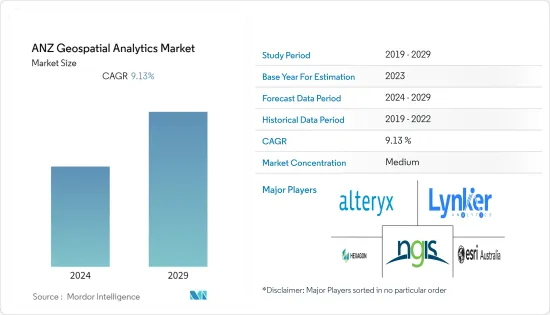
オーストラリア・ニュージーランドの地理空間分析市場規模は、予測期間中にCAGR 9.13%で、現在の6億2,000万米ドルから今後5年間で9億5,000万米ドルに成長すると予測されます。
オーストラリア・ニュージーランドの地理空間分析市場は、さまざまな公共と民間のエンドユーザー産業からの需要の増加、大手市場参入企業の存在、都市計画における地理空間分析の需要の増加によって牽引されています。
主要ハイライト
- オーストラリア・ニュージーランドの地理空間分析エコシステムは、市場参入企業による革新的な地理空間分析ソリューションの成長と、地理空間データから意味のある洞察を得るための人工知能(AI)や機械学習(ML)などの先進技術の利用増加により、ここ数年で大幅な成長を遂げています。さらに、情報に基づいた意思決定を行うために位置情報の利用が増加していることが、この地域における地理空間機能と地理空間分析ソリューションの需要をさらに押し上げています。
- 同地域の市場ベンダーは、先進技術を駆使して地理空間領域における革新的な分析機能を提供しており、これがさらに同地域のエンドユーザー産業における地理空間分析ソリューションの需要を押し上げていると分析されています。例えば、オーストラリアを拠点とするgeospatial intelligenceは、地理空間分析、ビッグデータ&リンク分析、機械学習、人工知能、効果的なユーザーインターフェースの開発においてかなりの専門知識を持っています。これらのスキルにより、同社は大規模なデータセットからデータや情報を自動抽出し、情報に基づいた意思決定をサポートする形式でこの情報を表示する、洗練された革新的な地理空間分析ツールを開発することができます。
- 衛星やセンサーなどから得られる地理空間データの利用可能性とアクセス性が高まっていることが、市場の成長を後押ししています。地理空間データは、地域全体の組織で地理空間分析ソリューションを活用することにより、情報に基づいた実質的な意思決定と貴重な洞察を提供できるからです。例えば、国土情報ニュージーランド(LINZ)は、ニュージーランドの建築物や自然環境をモデル化した詳細な地理空間データの公開に注力しています。LINZは、道路や河川のデータから航空画像やLiDARまで、データセットをdata.linz.govt.nzで共有しています。
- さらに2023年5月、Vexcel Data Programは、ウェブベースのプラットフォームであるViewerを通じて、ニュージーランドとオーストラリアの航空画像に無料でアクセスできることを発表しました。この無償アクセスにより、商業と政府機関のユーザーは、パース、オークランド、シドニー、メルボルン、ブリスベン、ウェリントン、クライストチャーチなどの主要都市圏の高解像度、高精度の画像を入手できます。オーストラリアとニュージーランドの組織は、この無料サービスに参加することができます。このような要因により、予測期間中、同地域の地理空間分析市場に成長機会がもたらされると期待されています。このような要因により、画像、衛星、センサーからの空間データから利益と競合優位性を最大化するための地理空間分析ソリューションに対する組織の需要が高まっています。
- COVID-19パンデミックの間、地理空間分析ソリューションは、この地域でCOVID-19パンデミックと戦うための重要な情報を提供するための大きな需要を示しました。EMSINA(Emergency Management Spatial Information Network Australia)などの地域の政府機関は、地理空間データセットを使用してパンデミックと戦うためにEsri Australiaなどの市場ベンダーと提携しました。パンデミック後、同地域の主要ベンダーが開発した革新的で洗練された地理空間分析ソリューションの増加により、同市場は大幅な成長を遂げています。
オーストラリア・ニュージーランドの地理空間分析市場動向
農業分野が大きな市場シェアを占めると予測
- オーストラリア・ニュージーランド地域の農業部門は、スマート農業や精密農業の実践に牽引され、ここ数年で大きく成長しています。同地域では、牛や小麦など多様な農産物を生産・輸出しており、農業は同地域の重要な経済分野となっています。圃場データのマッピング、整理・分析、作物の遠隔モニタリングなど、地理空間分析ソリューションにはさまざまな利点があります。
- 同地域の農業部門では、限られた資源を最大限に活用する方法を理解するために、高解像度の画像、現場観察、リアルタイムのデータフィードを統合することで、地理空間分析ソリューションの大幅な導入が進んでいます。Esri Australiaなどのベンダーは、農業分野における地理空間分析ソリューションの革新に積極的に取り組んでおり、市場の成長に影響を与えています。
- さらに、この地域には精密農業プロバイダーが数多く存在し、精密農業の実践を推進しています。精密農業には、GPS、ドローン、センサー、高度な分析など、さまざまな技術の利用が含まれます。精密農業の実践は、農場の意思決定と計画を改善するために地理空間分析の利用を求めると予想され、オーストラリア・ニュージーランド地域の農業部門における地理空間分析の需要を積極的に促進しています。
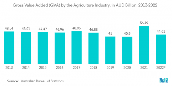
- さらに、オーストラリア・ニュージーランド地域では農業が不可欠になっており、この産業が地域のGDPを積極的に牽引しています。市場ベンダーが開発した農業分野に特化した地理空間ソリューションにより、同地域の農業業界が地理空間分析ソリューションを採用することで、農業業界に成長の見込みがもたらされ、市場の成長にプラスに働くとさらに分析されています。例えば、オーストラリア統計局のデータによると、2022年9月現在、オーストラリアの農業産業の粗付加価値(GVA)は440億1,000万豪ドル(約289億2,000万米ドル)に達しています。
オーストラリアは大幅な成長が見込まれる
- オーストラリアは、農業から都市計画まで様々なエンドユーザー業界からの需要が高まっていることから、今後数年間で地理空間分析ソリューションの大幅な導入が見込まれています。さらに同国には、多様な業界向けに地理空間分析製品を継続的に革新している著名な市場ベンダーが存在し、同国の市場成長にプラスの影響を与えています。
- 例えば、Experian Australiaは国内の小売業向けに地理空間分析ソリューションを提供しています。同社は地理空間分析・ソリューションを通じて、小売企業に対し、より効果的な立地選定、収益促進要因の特定、小売/支店のサービス・商品・消費者間のより良い整合性、店舗回転率のより正確な見積もり、競合の影響の理解向上などのメリットを提供しています。
- さらに、同国では都市化が進んでいるため、適切かつ効果的な都市計画のための地理空間分析ソリューションに対する需要がさらに高まっています。例えば、世界銀行のデータによると、オーストラリアの都市化率は2005年の84.22%から2022年には86.49%に上昇します。さらに、オーストラリアのGIS・デジタル分析・リモートセンシング(GDARS)実践分野委員会は、都市計画や天然資源管理から災害対応や公衆衛生に至るまで、さまざまな用途でGIS、デジタル分析、リモートセンシングが果たす重要な役割を認識しています。
- さらに、同国の公益事業会社は地理空間分析会社と提携し、ネットワークの調整に関するコアデータの問題に対処し、ネットワークの故障や損傷を減らすための予知保全戦略を実施しています。例えば、2022年11月、Horizon Powerの地理空間インテリジェンスプログラムは、リモートセンシング、画像、高度な分析技術を活用し、ネットワークの状態を迅速に把握する電力会社の能力を変革する地理空間インテリジェンス・ソリューションを提供しました。数千キロメートルに及ぶネットワークでは、地理空間情報プログラムによって資産のパフォーマンスが最適化され、ネットワークの信頼性と安全性が維持されます。同電力会社は、地理空間スペシャリストのAltavecにこのプログラムの提供を依頼しました。
オーストラリア・ニュージーランドの地理空間分析業界概要
オーストラリア・ニュージーランドの地理空間分析市場は、少数の大手ベンダーが大きな市場シェアを占めているため、適度に統合されています。同地域の市場参入企業は、パートナーシップや買収活動に耽溺しており、先進技術を統合した新しい革新的な地理空間分析ソリューションを発表しています。オーストラリア・ニュージーランドの地理空間分析市場における主要市場ベンダーには、NGIS Australia Pty Ltd(NGIS)、Alteryx、Hexagon AB、Esri Australia、Lynker Analytics Ltdなどがあります。
2022年12月、地理空間データ、分析、解析の専門プロバイダーであるオーストラリアのGeospatial Intelligence Pty Ltdは、高解像度衛星画像の世界の大手プロバイダーの1つであるSatellogicとの新たな提携を発表しました。Satellogicは、手頃な価格で高解像度の画像を収集する地球観測(EO)衛星の設計、製造、運用を行っています。同社の4つのマルチスペクトルバンド(青、赤、緑、近赤外)は、オルソ補正され、GISに対応し、直下70cmの解像度で提供されます。
その他の特典:
- エクセル形式の市場予測(ME)シート
- 3ヶ月間のアナリストサポート
目次
第1章 イントロダクション
- 調査の前提条件と市場定義
- 調査範囲
第2章 調査手法
第3章 エグゼクティブサマリー
第4章 市場洞察
- 市場概要
- 業界の魅力度-ポーターのファイブフォース分析
- 買い手の交渉力
- 供給企業の交渉力
- 新規参入業者の脅威
- 代替品の脅威
- 競争企業間の敵対関係
- 業界バリューチェーン分析
- COVID-19の市場への影響評価
第5章 市場力学
- 市場促進要因
- スマートシティ開発と都市計画における地理空間分析の需要の高まり
- 地理空間分析ソリューションにおけるAIやMLなどの先端技術の統合
- 市場抑制要因
- 地理空間分析ソリューションに関連するコストの上昇
第6章 市場セグメンテーション
- タイプ別
- サーフェス解析
- ネットワーク解析
- 地理視覚化
- 業界別
- 農業
- 公益事業と通信
- 防衛・情報
- 政府機関
- 鉱業・天然リソース
- 自動車・運輸
- 医療
- 不動産・建設
- その他のエンドユーザー業界別
- 国別
- オーストラリア
- ニュージーランド
第7章 競合情勢
- 企業プロファイル
- NGIS Australia Pty Ltd(NGIS)
- Alteryx
- Hexagon AB
- Esri Australia
- Lynker Analytics Ltd
- Intermap Technologies
- Mapizy Pty Ltd.
- New Zealand Geoanalytics Ltd.
- CoreLogic NZ Limited
- Abley Ltd
- Geospatial Intelligence Pty Ltd.
第8章 投資分析
第9章 市場機会と今後の動向
The ANZ geospatial analytics market size is expected to grow from USD 0.62 billion in the current year to USD 0.95 billion in the next five years at a CAGR of 9.13% during the forecast period. The ANZ geospatial analytics market is driven by the increasing demand from various public and private end-user industries, the presence of major market players, and the increasing demand for geospatial analytics in urban planning.
Key Highlights
- The ANZ geospatial analytics ecosystem has witnessed substantial growth in the past couple of years owing to the growth in innovative geospatial analytics solutions by the market players and the increasing use of advanced technologies such as artificial intelligence(AI) and machine learning(ML) for meaningful insights from the geospatial data. Moreover, the increasing use of location information to make informed decisions further drives the demand for geospatial capabilities and geospatial analytics solutions in the region.
- Market vendors in the region are using advanced technologies to offer innovative analytics capabilities in the geospatial domain, which is further analyzed to boost the demand for geospatial analytics solutions in the end-user industries across the region. For instance, Australia-based geospatial intelligence has considerable expertise in geospatial analysis, big data & link analytics, machine learning, artificial intelligence, and the development of effective user interfaces. These skills allow the company to develop sophisticated and innovative geospatial analytical tools that automate the extraction of data and information from large data sets and display this information in a format that supports informed decision-making.
- The increasing availability and accessibility of geospatial data from satellites, sensors, etc., aided the market's growth, as the geospatial data can provide substantial informed decisions and valuable insights by leveraging geospatial analytics solutions in organizations across the region. For instance, the National mapping agency Land Information New Zealand (LINZ) focused on publishing detailed geospatial data that models New Zealand's built and natural environments. LINZ shares its datasets-from road and river data to aerial imagery and LiDAR-on data.linz.govt.nz.
- Further, in May 2023, Vexcel Data Program announced free access to aerial imagery in New Zealand and Australia through its web-based platform, Viewer. This no-cost access provides commercial and government users with high-resolution, highly accurate imagery of major metro areas such as Perth, Auckland, Sydney, Melbourne, Brisbane, Wellington, and Christchurch. Australian and New Zealand organizations are eligible to participate in this free offering. Such factors are further expected to offer growth opportunities for the geospatial analytics market in the region over the forecast period. Such factors have driven organizations' demand for geospatial analytics solutions to maximize benefits and competitive edge from the spatial data from imagery, satellites, and sensors.
- During the COVID-19 pandemic, Geospatial Analytics Solutions witnessed substantial demand to offer Vital Information for Combating COVID-19 Pandemic in the region. Government organizations in the region, such as Emergency Management Spatial Information Network Australia (EMSINA), partnered with market vendors such as Esri Australia to combat the pandemic using geospatial datasets. Post-pandemic, the market is witnessing substantial growth owing to the increase in innovative and sophisticated geospatial analytics solutions developed by the major market vendors in the region.
ANZ Geospatial Analytics Market Trends
Agriculture Segment is Anticipated to Hold Significant Market Share
- The ANZ region's agriculture sector has grown substantially in the past few years, led by smart farming and precision agriculture practices. The region produces and exports a diverse range of agricultural products, including cattle, and wheat, making agriculture an important economic sector of the region. Various benefits are associated with geospatial analytics solutions, such as mapping field data, organizing and analyzing it, and monitoring their crops remotely.
- The agriculture sector in the region is witnessing substantial adoption of geospatial analytics solutions by integrating high-resolution imagery, field observations, and real-time data feeds to understand how to make the most of limited resources. Market vendors such as Esri Australia are actively innovating geospatial analytics solutions in the agriculture domain, thus impacting the growth of the market.
- Further, the region is promoting precision agriculture practices with the presence of many precision agriculture providers. Precision agriculture involves the use of various technologies, such as GPS, drones, sensors, and advanced analytics. Precision agriculture practices are expected to seek the use of geospatial analytics to improve farm decision-making and planning, thus positively driving the demand for geospatial analytics in the agriculture sector of the ANZ region.
- Additionally, agriculture is becoming vital in the ANZ region, with the industry actively driving the region's GDP. The agriculture industry's adoption of geospatial analytics solutions in the region owing to the agriculture sector-specific geospatial solutions developed by market vendors are further analyzed to offer growth prospects to the agriculture industry, thus positively impacting the growth of the market. For instance, according to the Australian Bureau of Statistics data, as of September 2022, the gross value added (GVA) of the agriculture industry in Australia reached AUD 44.01 billion (~USD 28.92 billion).
Australia is Expected to Witness Substantial Growth
- Australia is expected to witness substantial adoption of geospatial analytics solutions in the coming years owing to the growing demand from various end-user industries ranging from agriculture to urban planning. Moreover, the country is home to some of the prominent market vendors who are continuously innovating their geospatial analytics offerings for a diverse range of industries, thus positively impacting the market growth in the country.
- For instance, Experian Australia offers geospatial analytics solutions for the retail sector in the country. The company provides benefits for retail organizations through its geospatial analytics solutions, such as more effective site selection, identification of profitability drivers, better alignment between retail/branch services, products, and consumers, more accurate estimates of store turnover, and improved understanding of competitor impact.
- Moreover, the high degree of urbanization in the country is further driving the demand for geospatial analytics solutions for proper and effective urban planning. For instance, according to the data from the World Bank, urbanization in Australia increased from 84.22% in 2005 to 86.49% in 2022. Further, the GIS, Digital Analytics, and Remote Sensing (GDARS) Area of Practice Committee in Australia recognizes the critical role that GIS, digital analytics, and remote sensing play in various applications, from urban planning and natural resource management to disaster response and public health.
- Further, utility companies in the country are partnering with geospatial analytics companies to deal with core data issues with network alignment and implement predictive maintenance strategies to reduce network failures and damages. For instance, in November 2022, Horizon Power's Geospatial Intelligence Program leveraged remote sensing, imagery, and advanced analytic technologies to deliver a geospatial intelligence solution that transforms the utility's ability to understand the state of the network quickly. With a network spanning thousands of kilometers, the geospatial intelligence program will optimize asset performance and keep the network reliable and safe. The utility company has selected geospatial specialist Altavec to deliver the program.
ANZ Geospatial Analytics Industry Overview
The ANZ geospatial analytics market is moderately consolidated owing to a few major market vendors holding significant market share. The market players in the region are indulging in partnership and acquisition activities and launching new innovative geospatial analytics solutions with the integration of advanced technologies. A few major market vendors in the ANZ geospatial analytics market include NGIS Australia Pty Ltd (NGIS), Alteryx, Hexagon AB, Esri Australia, and Lynker Analytics Ltd, among others.
In December 2022, Australia-based Geospatial Intelligence Pty Ltd, a specialist geospatial data, analysis, and analytics provider, announced a new partnership with Satellogic, one of the leading global providers of high-resolution satellite imagery. Satellogic designs, builds, and operates its fleet of earth observation (EO) satellites to collect affordable, high-resolution imagery. Its four multispectral bands (blue, red, green, near-IR) are delivered ortho-rectified and GIS-ready, available at 70 cm resolution on nadir.
Additional Benefits:
- The market estimate (ME) sheet in Excel format
- 3 months of analyst support
TABLE OF CONTENTS
1 INTRODUCTION
- 1.1 Study Assumptions and Market Definition
- 1.2 Scope of the Study
2 RESEARCH METHODOLOGY
3 EXECUTIVE SUMMARY
4 MARKET INSIGHTS
- 4.1 Market Overview
- 4.2 Industry Attractiveness - Porter's Five Forces Analysis
- 4.2.1 Bargaining Power of Buyers
- 4.2.2 Bargaining Power of Suppliers
- 4.2.3 Threat of New Entrants
- 4.2.4 Threat of Substitutes
- 4.2.5 Intensity of Competitive Rivalry
- 4.3 Industry Value Chain Analysis
- 4.4 Assessment of the Impact of COVID-19 on the Market
5 MARKET DYNAMICS
- 5.1 Market Drivers
- 5.1.1 Growing Demand for Geospatial Analytics in Smart City Development and Urban Planning
- 5.1.2 Integration of Advanced Technologies such as AI and ML in Geospatial Analytics Solutions
- 5.2 Market Restraints
- 5.2.1 Higher Costs Associated With Geospatial Analytics Solutions
6 MARKET SEGMENTATION
- 6.1 By Type
- 6.1.1 Surface Analysis
- 6.1.2 Network Analysis
- 6.1.3 Geovisualization
- 6.2 By End-user Vertical
- 6.2.1 Agriculture
- 6.2.2 Utility and Communication
- 6.2.3 Defense and Intelligence
- 6.2.4 Government
- 6.2.5 Mining and Natural Resources
- 6.2.6 Automotive and Transportation
- 6.2.7 Healthcare
- 6.2.8 Real Estate and Construction
- 6.2.9 Other End-user Verticals
- 6.3 By Country
- 6.3.1 Australia
- 6.3.2 New Zealand
7 COMPETITIVE LANDSCAPE
- 7.1 Company Profiles
- 7.1.1 NGIS Australia Pty Ltd (NGIS)
- 7.1.2 Alteryx
- 7.1.3 Hexagon AB
- 7.1.4 Esri Australia
- 7.1.5 Lynker Analytics Ltd
- 7.1.6 Intermap Technologies
- 7.1.7 Mapizy Pty Ltd.
- 7.1.8 New Zealand Geoanalytics Ltd.
- 7.1.9 CoreLogic NZ Limited
- 7.1.10 Abley Ltd
- 7.1.11 Geospatial Intelligence Pty Ltd.