
|
市場調査レポート
商品コード
1773241
土地調査機器の市場機会、成長促進要因、産業動向分析、2025年~2034年予測Land Survey Equipment Market Opportunity, Growth Drivers, Industry Trend Analysis, and Forecast 2025 - 2034 |
||||||
カスタマイズ可能
|
|||||||
| 土地調査機器の市場機会、成長促進要因、産業動向分析、2025年~2034年予測 |
|
出版日: 2025年06月16日
発行: Global Market Insights Inc.
ページ情報: 英文 190 Pages
納期: 2~3営業日
|

全表示
- 概要
- 目次
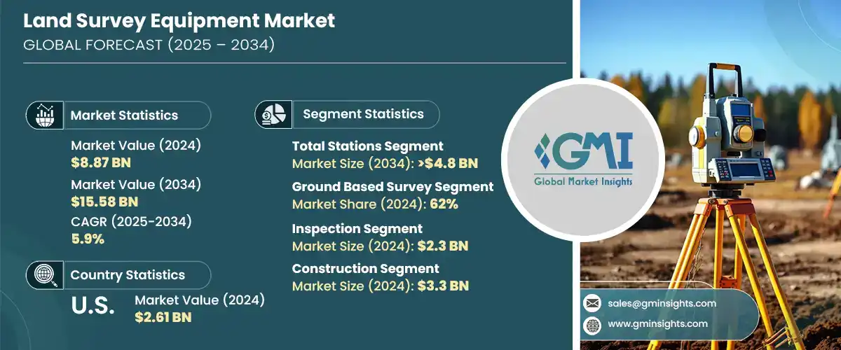
土地調査機器の世界市場規模は2024年に88億7,000万米ドルとなり、CAGR 5.9%で成長し、2034年には155億8,000万米ドルに達すると予測されています。
この市場拡大の背景には、農業、建設、インフラ、鉱業などの分野で正確な地理空間情報に対するニーズが高まっていることがあります。産業界が効率性、安全性、精度を優先し続ける中、次世代測量技術への需要が勢いを増しています。従来の測量技術は、GNSS受信機、ロボットトータルステーション、3Dレーザースキャナーなどの先進的なツールに急速に取って代わられつつあります。これらのソリューションにより、測量士はより速く、より正確にデータを収集できるようになり、その結果、地形図が改善され、より良いプロジェクトが遂行できるようになりました。測量技術は、農業における土地利用の最適化から、鉱業における作業安全性の向上まで、さまざまな用途で不可欠なものとなっています。
世界中の産業界が、複雑な土地開発や計画イニシアチブにこれらの最新機器がもたらす利点をますます認識するようになっています。GNSS受信機、ロボット型トータルステーション、3Dレーザースキャナーなど、これらの高度な測量ツールは、比類のない精度、より迅速なデータ収集、リアルタイムの分析を提供し、プロジェクトのタイムラインを短縮し、コストのかかるエラーを排除するのに役立ちます。インフラ開発や交通計画から大規模な農業や鉱業まで、高解像度の空間データを短時間で取得できるようになったことで、プロジェクトの開始、管理、実施方法に革命が起きています。建設、公共事業、エネルギーなどの分野でも、ワークフローを合理化し、マッピングとモデリングの精度を高め、安全性と環境への影響に関するますます厳しくなる規制に準拠するために、こうした技術革新が注目されています。
| 市場範囲 | |
|---|---|
| 開始年 | 2024 |
| 予測年 | 2025-2034 |
| 開始金額 | 88億7,000万米ドル |
| 予測金額 | 155億8,000万米ドル |
| CAGR | 5.9% |
2024年、トータルステーション部門は34.04%のシェアを占め、2034年には48億米ドルに達すると予測されています。角度と距離を測定する統合的な能力により、高精度の作業で高い価値を発揮します。その汎用性と費用対効果により、特に交通機関や都市インフラ開発など、さまざまな分野で好まれています。GNSS互換性、ワイヤレス接続性、ロボットによる自動化といった最近の技術革新は、ワークフローを合理化し、その能力を拡大しています。
地上測量システムは2024年に62%のシェアを占め、2025年から2034年にかけてCAGR 5%で成長すると予想されています。このカテゴリーには、GNSSシステム、水準器、トータルステーションなど、伝統的なものと最新の土地調査機器の両方が含まれます。GNSSの適応性、信頼性、アクセシビリティは、特に建設や都市計画などの分野において、幅広いプロジェクトに適しています。大規模な都市インフラが需要を牽引し続けるアジアや欧州の高成長市場においても、地上測量は引き続き不可欠です。
米国の土地調査機器2024年の市場シェアは77.1%で、26億1,000万米ドル。北米は、AI統合アナリティクス、3Dスキャン技術、UAVベースの測量ツールなど、先進的な土地測量システムの導入で世界をリードしています。米国市場は、特にスマートインフラや建設のデジタル化におけるイニシアチブを通じたデジタル化の急速な受け入れで際立っています。HexagonやTrimbleなどの企業は、リアルタイムで高精度なデータへのニーズの高まりに対応するため、製品のアップグレード、調査、デジタル変換に継続的に投資することで、この地域の技術的展望を形成する上で大きな役割を果たしています。
土地調査機器業界を形成する主要企業には、GeoTech、Hexagon、Topcon、Trimble、Stonex、DeepWell、FARO、Bosch Tools、Emlid Tech、Shanghai Huace Navigation Technologyなどがあります。土地調査機器市場の企業は、進化する業界の需要に応える革新的で多機能、高精度のソリューションを生み出すため、研究開発に多額の投資を行っています。多くの企業がAI、IoT、無線技術を測量機器に統合し、自動化、リアルタイムデータ処理、クラウド対応を強化しています。建設・インフラ企業とのパートナーシップや戦略的提携も、顧客基盤拡大のカギを握っています。各社は、遠隔地や都市部での測量の課題に対応するため、コンパクトで堅牢、モバイルフレンドリーな機器の開発を重視しています。さらに各社は、機器の持続可能性と長期的な保守性を重視しながら、地域市場によりよく対応するため、生産とサポートサービスの現地化を進めています。
目次
第1章 調査手法と範囲
第2章 エグゼクティブサマリー
第3章 業界考察
- エコシステム分析
- サプライヤーの情勢
- 電子部品サプライヤー
- 機器メーカー
- サービスプロバイダー
- システムインテグレーター
- 最終用途
- コスト構造
- 利益率
- 各段階での付加価値
- サプライチェーンに影響を与える要因
- 破壊者
- サプライヤーの情勢
- 影響要因
- 促進要因
- 世界のインフラブームにより、正確な土地測量の需要が高まっている
- GNSS、3Dスキャナー、ドローンが土地測量に革命を起こす
- 農家や鉱山労働者は精密作業に測量技術を活用している
- GISの拡大により測量グレードの地理空間データの必要性が高まる
- 業界の潜在的リスク&課題
- GNSSと3Dスキャナーの高コストが小規模測量会社の制約となっている
- スキル格差が高度な測量技術の導入を妨げている
- 市場機会
- 政府の土地評価義務により測量需要が維持される
- 遠隔トレーニングとリアルタイム調査支援のためのAR/VRの統合
- 促進要因
- 成長可能性分析
- ポーター分析
- PESTEL分析
- テクノロジーとイノベーションの情勢
- 現在の技術
- 高精度RTKおよびPPK GNSS/GPSシステム
- ロボット式および電動式トータルステーション
- 3Dレーザースキャナーにおける地上およびモバイルLiDAR
- 写真測量とLiDARマッピングドローン/UAV
- 新興技術
- データ処理のためのAIと機械学習
- 自律測量ロボット
- 現場の可視化のための拡張現実(AR)
- 安全な地理空間データ管理のためのブロックチェーン
- 現在の技術
- 特許分析
- 規制情勢
- 北米
- 欧州
- アジア太平洋地域
- ラテンアメリカ
- 中東・アフリカ
- 生産統計
- 生産拠点
- 消費拠点
- 輸出と輸入
- コスト内訳分析
- 持続可能性分析
- 持続可能な慣行
- 廃棄物削減戦略
- 生産におけるエネルギー効率
- 環境に優しい取り組み
- カーボンフットプリントの考慮
第4章 競合情勢
- イントロダクション
- 企業の市場シェア分析
- 北米
- 欧州
- アジア太平洋地域
- ラテンアメリカ
- 中東・アフリカ
- 競合ポジショニングマトリックス
- 戦略的展望マトリックス
- 主な発展
- 合併と買収
- パートナーシップとコラボレーション
- 新製品の発売
- 拡張計画と資金調達
第5章 市場推計・予測:製品別、2021年~2034年
- 主要動向
- トータルステーション
- GPS/GNSSシステム
- レーザースキャナー
- レベル
- 無人航空機(UAV)/ドローン
- その他
第6章 市場推計・予測:調査方法別、2021年~2034年
- 主要動向
- 地上調査
- レーザー調査
第7章 市場推計・予測:用途別、2021年~2034年
- 主要動向
- 検査
- 品質管理検査
- 構造検査
- インフラ検査
- 監視
- 環境モニタリング
- 土地利用モニタリング
- 測地モニタリング
- マッピング
- エンジニアリングと設計
- 体積計算
- 土工計算
- 備蓄量の計算
- 切土量と盛土量の計算
- レイアウトポイント
- 建設現場のレイアウト
- パイプラインとユーティリティの調査
- 道路と高速道路のレイアウト
- 地理情報システム(GIS)
- 土地開発計画
- 農業測量
- その他
第8章 市場推計・予測:最終用途別、2021年~2034年
- 主要動向
- 建設
- 石油・ガス
- 鉱業
- ユーティリティ
- 農業
- 防衛とセキュリティ
- その他
第9章 市場推計・予測:地域別、2021年~2034年
- 北米
- 米国
- カナダ
- 欧州
- 英国
- ドイツ
- フランス
- イタリア
- スペイン
- ロシア
- 北欧諸国
- アジア太平洋地域
- 中国
- インド
- 日本
- 韓国
- オーストラリア
- 東南アジア
- ラテンアメリカ
- ブラジル
- メキシコ
- アルゼンチン
- チリ
- 中東・アフリカ
- 南アフリカ
- サウジアラビア
- アラブ首長国連邦
第10章 企業プロファイル
- Aptella
- Baseline Equipment Company
- Bosch Tools
- DeepWell
- Emlid Tech
- FARO
- GeoTech
- Guangdong KOLIDA Instrument
- Hexagon
- Hi-Target
- Juniper Systems
- Seiler Instrument Company
- Shanghai Huace Navigation Technology
- South Surveying &Mapping Technology Company
- Spectra Geospatial
- Stonex
- Suparule Systems
- Teledyne
- Topcon
- Trimble
The Global Land Survey Equipment Market was valued at USD 8.87 billion in 2024 and is estimated to grow at a CAGR of 5.9% to reach USD 15.58 billion by 2034. This expansion is driven by the growing need for accurate geospatial information across sectors such as agriculture, construction, infrastructure, and mining. As industries continue to prioritize efficiency, safety, and precision, demand for next-generation surveying technologies has gained momentum. Traditional surveying techniques are rapidly being replaced by advanced tools like GNSS receivers, robotic total stations, and 3D laser scanners. These solutions enable surveyors to collect data faster and more accurately, resulting in improved terrain mapping and better project execution. Surveying technology has become indispensable in multiple applications, from optimizing land usage in agriculture to enhancing operational safety in mining.
Industries around the world are now increasingly aware of the advantages these modern instruments bring to complex land development and planning initiatives. These advanced surveying tools, such as GNSS receivers, robotic total stations, and 3D laser scanners, offer unmatched precision, faster data collection, and real-time analytics, helping reduce project timelines and eliminate costly errors. From infrastructure development and transportation planning to large-scale agricultural and mining operations, the ability to capture high-resolution spatial data in a fraction of the time has revolutionized how projects are initiated, managed, and executed. Sectors like construction, utilities, and energy are also turning to these innovations to streamline workflow, enhance accuracy in mapping and modeling, and comply with increasingly stringent regulations around safety and environmental impact.
| Market Scope | |
|---|---|
| Start Year | 2024 |
| Forecast Year | 2025-2034 |
| Start Value | $8.87 Billion |
| Forecast Value | $15.58 Billion |
| CAGR | 5.9% |
In 2024, the total stations segment held a 34.04% share and is anticipated to hit USD 4.8 billion by 2034. Their integrated ability to measure angles and distances makes them highly valuable for high-precision work. Their versatility and cost-effectiveness make them a preferred tool across a range of sectors, particularly for transportation and urban infrastructure developments. Recent innovations such as GNSS compatibility, wireless connectivity, and robotic automation are streamlining workflow and expanding their capabilities.
Ground-based survey systems segment held a 62% share in 2024 and is expected to grow at a CAGR of 5% from 2025 to 2034. This category covers both traditional and contemporary land survey equipment like GNSS systems, levels, and total stations. Their adaptability, reliability, and accessibility make them suitable for a broad array of project scopes, particularly in sectors like construction and city planning. Ground-based surveys remain essential across high-growth markets in Asia and Europe, where large-scale urban infrastructure continues to drive demand.
U.S. Land Survey Equipment Market accounted for a 77.1% share in 2024, generating USD 2.61 billion. North America leads globally in adopting advanced land surveying systems, including AI-integrated analytics, 3D scanning technologies, and UAV-based survey tools. The U.S. market stands out for its fast embrace of digitalization, especially through initiatives in smart infrastructure and construction digitization. Companies like Hexagon and Trimble play a major role in shaping the region's technological landscape by continually investing in product upgrades, research, and digital transformation to meet the growing need for real-time, high-accuracy data.
Key players shaping the Land Survey Equipment Industry include GeoTech, Hexagon, Topcon, Trimble, Stonex, DeepWell, FARO, Bosch Tools, Emlid Tech, and Shanghai Huace Navigation Technology. Companies in the land survey equipment market are investing significantly in R&D to create innovative, multi-functional, and high-accuracy solutions that cater to evolving industry demands. Many are integrating AI, IoT, and wireless technologies into survey equipment to enhance automation, real-time data processing, and cloud compatibility. Partnerships and strategic collaborations with construction and infrastructure firms are also key to expanding client bases. Players are emphasizing the development of compact, rugged, and mobile-friendly devices to address remote and urban survey challenges. Additionally, companies are localizing production and support services to better cater to regional markets while focusing on sustainability and long-term serviceability of equipment.
Table of Contents
Chapter 1 Methodology & Scope
- 1.1 Research design
- 1.1.1 Research approach
- 1.1.2 Data collection methods
- 1.2 Base estimates & calculations
- 1.2.1 Base year calculation
- 1.2.2 Key trends for market estimation
- 1.3 Forecast model
- 1.4 Primary research and validation
- 1.4.1 Primary sources
- 1.4.2 Data mining sources
- 1.5 Market scope & definition
Chapter 2 Executive Summary
- 2.1 Industry synopsis, 2021 – 2034
- 2.2 Key market trends
- 2.2.1 Regional
- 2.2.2 Product
- 2.2.3 Survey method
- 2.2.4 Application
- 2.2.5 End Use
- 2.3 TAM Analysis, 2025-2034
- 2.4 CXO perspectives: Strategic imperatives
- 2.4.1 Key decision points for industry executives
- 2.4.2 Critical success factors for market players
- 2.5 Future Outlook and Strategic Recommendations
Chapter 3 Industry Insights
- 3.1 Industry ecosystem analysis
- 3.1.1 Supplier landscape
- 3.1.1.1 Electronic component suppliers
- 3.1.1.2 Equipment manufacturers
- 3.1.1.3 Service providers
- 3.1.1.4 System integrators
- 3.1.1.5 End use
- 3.1.2 Cost structure
- 3.1.3 Profit margin
- 3.1.4 Value addition at each stage
- 3.1.5 Factors impacting the supply chain
- 3.1.6 Disruptors
- 3.1.1 Supplier landscape
- 3.2 Impact on forces
- 3.2.1 Growth drivers
- 3.2.1.1 The global infrastructure boom drives demand for accurate land surveys
- 3.2.1.2 GNSS, 3D scanners, and drones revolutionize land surveying
- 3.2.1.3 Farmers and miners leverage survey tech for precision operations
- 3.2.1.4 GIS expansion fuels need for survey-grade geospatial data
- 3.2.2 Industry pitfalls & challenges
- 3.2.2.1 High costs of GNSS & 3D scanners restrict small survey firms
- 3.2.2.2 Skill gap hinders the adoption of advanced surveying technology
- 3.2.3 Market Opportunities
- 3.2.3.1 Government land assessment mandates sustain surveying demand
- 3.2.3.2 Integration of AR/VR for remote training and real-time survey assistance
- 3.2.1 Growth drivers
- 3.3 Growth potential analysis
- 3.4 Porter's analysis
- 3.5 PESTEL analysis
- 3.6 Technology & innovation landscape
- 3.6.1 Current technologies
- 3.6.1.1 High-precision RTK & PPK GNSS/GPS Systems
- 3.6.1.2 Robotic & Motorized Total Stations
- 3.6.1.3 Terrestrial & Mobile LiDAR in 3D Laser Scanners
- 3.6.1.4 Photogrammetry & LiDAR Mapping Drones/UAVs
- 3.6.2 Emerging technologies
- 3.6.2.1 AI & machine learning for data processing
- 3.6.2.2 Autonomous surveying robots
- 3.6.2.3 Augmented reality (AR) for field visualization
- 3.6.2.4 Blockchain for secure geospatial data management
- 3.6.1 Current technologies
- 3.7 Patent analysis
- 3.8 Regulatory landscape
- 3.8.1 North America
- 3.8.2 Europe
- 3.8.3 Asia Pacific
- 3.8.4 Latin America
- 3.8.5 Middle East & Africa
- 3.9 Production statistics
- 3.9.1 Production hubs
- 3.9.2 Consumption hubs
- 3.9.3 Export and import
- 3.10 Cost breakdown analysis
- 3.11 Sustainability analysis
- 3.11.1 Sustainable practices
- 3.11.2 Waste reduction strategies
- 3.11.3 Energy efficiency in production
- 3.11.4 Eco-friendly initiatives
- 3.11.5 Carbon footprint considerations
Chapter 4 Competitive Landscape, 2024
- 4.1 Introduction
- 4.2 Company market share analysis
- 4.2.1 North America
- 4.2.2 Europe
- 4.2.3 Asia Pacific
- 4.2.4 Latin America
- 4.2.5 Middle East & Africa
- 4.3 Competitive positioning matrix
- 4.4 Strategic outlook matrix
- 4.5 Key developments
- 4.5.1 Mergers & acquisitions
- 4.5.2 Partnerships & collaborations
- 4.5.3 New Product Launches
- 4.5.4 Expansion Plans and funding
Chapter 5 Market Estimates & Forecast, By Product, 2021 - 2034 ($Bn, Units)
- 5.1 Key trends
- 5.2 Total stations
- 5.3 GPS/GNSS systems
- 5.4 Laser scanners
- 5.5 Levels
- 5.6 Unmanned Aerial Vehicles (UAV)/Drones
- 5.7 Others
Chapter 6 Market Estimates & Forecast, By Survey Method, 2021 - 2034 ($Bn, Units)
- 6.1 Key trends
- 6.2 Ground-based surveys
- 6.3 Laser surveys
Chapter 7 Market Estimates & Forecast, By Application, 2021 - 2034 ($Bn, Units)
- 7.1 Key trends
- 7.2 Inspection
- 7.2.1 Quality control inspections
- 7.2.2 Structural inspections
- 7.2.3 Infrastructure inspections
- 7.3 Monitoring
- 7.3.1 Environmental monitoring
- 7.3.2 Land use monitoring
- 7.3.3 Geodetic monitoring
- 7.4 Mapping
- 7.5 Engineering & design
- 7.6 Volumetric calculation
- 7.6.1 Earthwork calculations
- 7.6.2 Stockpile volume calculations
- 7.6.3 Cut and fill volume calculations
- 7.7 Layout points
- 7.7.1 Site layout for construction
- 7.7.2 Surveying for pipelines and utilities
- 7.7.3 Road and highway layout
- 7.8 Geographic Information Systems (GIS)
- 7.9 Land development planning
- 7.10 Agricultural surveying
- 7.11 Others
Chapter 8 Market Estimates & Forecast, By End use, 2021 - 2034 ($Bn, Units)
- 8.1 Key trends
- 8.2 Construction
- 8.3 Oil & gas
- 8.4 Mining
- 8.5 Utilities
- 8.6 Agriculture
- 8.7 Defense & security
- 8.8 Others
Chapter 9 Market Estimates & Forecast, By Region, 2021 - 2034 ($Bn, Units)
- 9.1 North America
- 9.1.1 U.S.
- 9.1.2 Canada
- 9.2 Europe
- 9.2.1 UK
- 9.2.2 Germany
- 9.2.3 France
- 9.2.4 Italy
- 9.2.5 Spain
- 9.2.6 Russia
- 9.2.7 Nordics
- 9.3 Asia Pacific
- 9.3.1 China
- 9.3.2 India
- 9.3.3 Japan
- 9.3.4 South Korea
- 9.3.5 Australia
- 9.3.6 Southeast Asia
- 9.4 Latin America
- 9.4.1 Brazil
- 9.4.2 Mexico
- 9.4.3 Argentina
- 9.4.4 Chile
- 9.5 MEA
- 9.5.1 South Africa
- 9.5.2 Saudi Arabia
- 9.5.3 UAE
Chapter 10 Company Profiles
- 10.1 Aptella
- 10.2 Baseline Equipment Company
- 10.3 Bosch Tools
- 10.4 DeepWell
- 10.5 Emlid Tech
- 10.6 FARO
- 10.7 GeoTech
- 10.8 Guangdong KOLIDA Instrument
- 10.9 Hexagon
- 10.10 Hi-Target
- 10.11 Juniper Systems
- 10.12 Seiler Instrument Company
- 10.13 Shanghai Huace Navigation Technology
- 10.14 South Surveying & Mapping Technology Company
- 10.15 Spectra Geospatial
- 10.16 Stonex
- 10.17 Suparule Systems
- 10.18 Teledyne
- 10.19 Topcon
- 10.20 Trimble
