
|
市場調査レポート
商品コード
1671874
エアリアルイメージング市場:用途別、最終用途産業別、地域別Aerial Imaging Market, By Application, By End-use Industry, By Geography |
||||||
カスタマイズ可能
|
|||||||
| エアリアルイメージング市場:用途別、最終用途産業別、地域別 |
|
出版日: 2025年02月17日
発行: Coherent Market Insights
ページ情報: 英文 135 Pages
納期: 2~3営業日
|

全表示
- 概要
- 目次
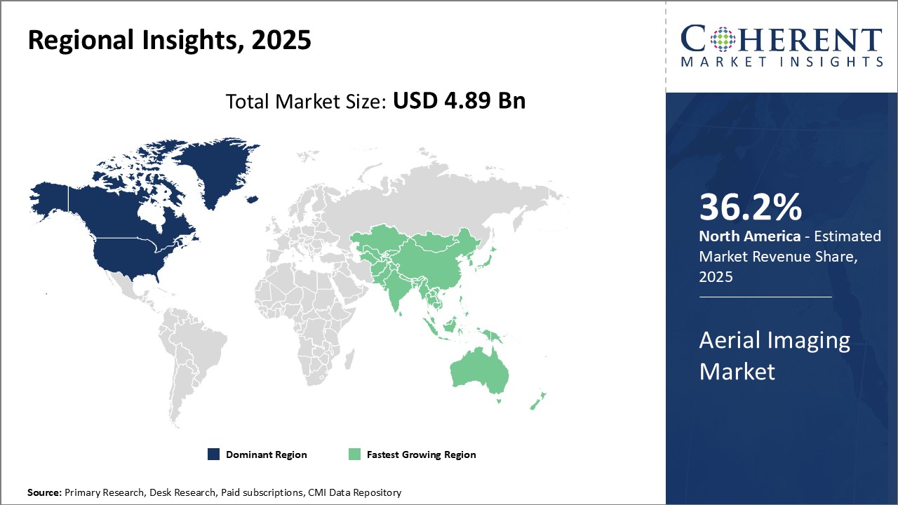
世界のエアリアルイメージング市場は、2025年には48億9,000万米ドルと推定され、2032年には145億9,000万米ドルに達すると予測され、2025年から2032年にかけて16.9%の複合年間成長率(CAGR)で成長する見込みです。
| レポート範囲 | レポート詳細 | ||
|---|---|---|---|
| 基準年 | 2024年 | 2025年の市場規模 | 48億9,000万米ドル |
| 実績データ | 2020年~2024年 | 予測期間 | 2025年~2032年 |
| 予測期間:2025年~2032年 CAGR: | 16.90% | 2032年の価値予測 | 145億9,000万米ドル |
エアリアルイメージング市場とは、航空機、ドローン、ヘリコプター、気球、その他の空中システムに搭載されたカメラを用いて、高所から地上の写真や動画を撮影する技術とサービスを指します。この空中画像は地形を俯瞰することができ、農業、建設、ドキュメンタリー映画制作、エネルギー・資源管理、環境モニタリング、映画・テレビ制作、地域・科学、政府、メディア・娯楽、鉱業、不動産・観光、その他の産業で幅広く利用されています。エアリアルイメージングは、従来の地上からの方法に比べ、わずかな時間で広範囲をモニタリングでき、詳細な分析に適した高解像度画像を提供します。
市場力学:
世界のエアリアルイメージング市場は、空間データおよびマッピングアプリケーションの需要増加、精密農業の台頭、建設およびインフラ開拓活動の拡大、ドローンベースの画像処理の採用などの要因によって牽引されています。しかし、ドローンの商業利用を取り巻く厳しい規制や、無許可の空中監視に伴うプライバシーの問題が市場成長の妨げとなっています。AIを搭載した画像解析ソリューションの開発と高度なセンサーと統合されたドローンの採用は、大きな成長機会をもたらします。環境モニタリング、監視、検査での用途拡大も需要を促進します。
この調査の主な特徴
- この調査レポートは、世界のエアリアルイメージング市場を詳細に分析し、2024年を基準年とした予測期間(2025-2032年)の市場規模および複合年間成長率(CAGR %)を掲載しています。
- また、さまざまなセグメントにおける潜在的な収益成長機会を明らかにし、この市場の魅力的な投資提案マトリクスについて解説しています。
- また市場促進要因、抑制要因、機会、新製品の発売や承認、市場動向、地域別の展望、主要企業が採用する競争戦略などに関する重要な考察も提供しています。
- 本レポートでは、企業ハイライト、製品ポートフォリオ、主要なハイライト、財務実績、戦略などのパラメータに基づいて、世界のエアリアルイメージング市場の主要企業をプロファイルしています。
- 本レポートからの洞察は、マーケティング担当者や企業の経営陣が、将来の製品の発売、タイプのアップグレード、市場拡大、マーケティング戦術に関する情報に基づいた意思決定を行うことを可能にします。
- この調査レポートは、投資家、サプライヤー、製品メーカー、流通業者、新規参入者、財務アナリストなど、この業界の様々な利害関係者を対象としています。
- 利害関係者は、世界のエアリアルイメージング市場の分析に使用される様々な戦略マトリックスを通じて、意思決定を容易にすることができます。
目次
第1章 調査の目的と前提条件
- 調査目的
- 前提条件
- 略語
第2章 市場の展望
- レポートの説明
- 市場の定義と範囲
- エグゼクティブサマリー
- Coherent Opportunity Map(COM)
第3章 市場力学、規制、動向分析
- 市場力学
- 促進要因
- 抑制要因
- 市場機会
- 規制シナリオ
- 業界動向
- 合併と買収
- 新システムの導入/承認
- COVID-19パンデミックの影響
第4章 世界のエアリアルイメージング市場:用途別、2020年~2032年
- エネルギー
- 地理空間技術
- 天然資源管理
- 建設・開発
- 災害対応管理
- 防衛と諜報
- 保全と調査
- メディアとエンターテイメント
第5章 世界のエアリアルイメージング市場:最終用途産業別、2020年~2032年
- 政府
- 商業企業
- 土木産業
- 軍隊
- 林業と農業
- エネルギー部門
- 保険
第6章 世界のエアリアルイメージング市場:地域別、2020年~2032年
- 北米
- 欧州
- アジア太平洋
- ラテンアメリカ
- 中東・アフリカ
第7章 競合情勢
- 企業プロファイル
- 3D Robotics
- Aerial Imaging Productions, LLC
- Aerobotics,(Pty)Ltd.
- Airobotics GmbH
- Blom Norway AS
- Cooper Aerial Surveys Co.
- Datumate
- Digital Aerial Solutions, LLC
- Drone Deplay, Inc
- Eagle Aerial Solutions
- EagleView Technologies, Inc.
- Fugro NV
- GeoVantage, Inc.(Aeroptic, LLC)
- Global UAV Technologies Ltd
- Kucera International Inc.
- Landiscor Real Estate Mapping
- Nearmap Ltd.
- PrecisionHawk
- SkyIMD, Inc.
- SZ D JI Technology Co. Ltd
- Terra Flight Aerial Imaging Inc.
- Verisk
第8章 運命の輪
- 運命の輪
- アナリストの見解
- 一貫した機会マップ
第9章 セクション
- 参考文献
- 調査手法
Global Aerial Imaging Market is estimated to be valued at USD 4.89 Bn in 2025 and is expected to reach USD 14.59 Bn by 2032, growing at a compound annual growth rate (CAGR) of 16.9% from 2025 to 2032.
| Report Coverage | Report Details | ||
|---|---|---|---|
| Base Year: | 2024 | Market Size in 2025: | USD 4.89 Bn |
| Historical Data for: | 2020 To 2024 | Forecast Period: | 2025 To 2032 |
| Forecast Period 2025 to 2032 CAGR: | 16.90% | 2032 Value Projection: | USD 14.59 Bn |
Aerial imaging market refers to the technology and services that capture photographs or videos of the ground from an elevated perspective using cameras mounted on aircraft, drones, helicopters, balloons, or other airborne systems. This airborne imagery provides bird's eye view of the terrain and has wide applications in agriculture, construction, documentary filmmaking, energy and resource management, environmental monitoring, film & television production, geography & science, government, media & entertainment, mining, real estate & tourism, and other industries. Aerial imagery allows the monitoring of large areas in a fraction of time compared to traditional ground-based methods and offers high-resolution images suitable for detailed analysis.
Market Dynamics:
The global aerial imaging market is driven by factors such as an increasing demand for spatial data and mapping applications, rise of precision agriculture, growing construction and infrastructure development activities, and adoption of drone-based imaging. However, strict regulations surrounding the commercial use of drones and privacy issues associated with unauthorized aerial surveillance hinder the market growth. Development of AI-powered image analysis solutions and adoption of drones integrated with advanced sensors present significant growth opportunities. Expanding applications in environment monitoring, surveillance, and inspections also propel the demand.
Key features of the study:
- This report provides an in-depth analysis of the global aerial imaging market, and provides market size (US$ Billion) and compound annual growth rate (CAGR %) for the forecast period (2025-2032), considering 2024 as the base year.
- It elucidates potential revenue growth opportunities across different segments and explains attractive investment proposition matrices for this market.
- This study also provides key insights about market drivers, restraints, opportunities, new product launches or approvals, market trends, regional outlook, and competitive strategies adopted by key players.
- It profiles key players in the global aerial imaging market based on the following parameters - company highlights, products portfolio, key highlights, financial performance, and strategies.
- Key companies covered as a part of this study include 3D Robotics, Aerial Imaging Productions, LLC, Aerobotics, (Pty) Ltd., Airobotics GmbH, Blom Norway AS, Cooper Aerial Surveys Co., Datumate, Digital Aerial Solutions, LLC, Drone Deplay, Inc, Eagle Aerial Solutions, EagleView Technologies, Inc., Fugro N.V., GeoVantage, Inc. (Aeroptic, LLC), Global UAV Technologies Ltd, Kucera International Inc., Landiscor Real Estate Mapping, Nearmap Ltd., PrecisionHawk , SkyIMD, Inc., SZ D JI Technology Co. Ltd , Terra Flight Aerial Imaging Inc., and Verisk.
- Insights from this report would allow marketers and the management authorities of the companies to make informed decisions regarding their future product launches, type up-gradation, market expansion, and marketing tactics.
- The global aerial imaging market report caters to various stakeholders in this industry including investors, suppliers, product manufacturers, distributors, new entrants, and financial analysts.
- Stakeholders would have ease in decision-making through various strategy matrices used in analyzing the global aerial imaging market.
Market Segmentation
- Application
- Energy
- Geospatial Technology
- Natural Resources Management
- Construction & Development
- Disaster Response Management
- Defense & Intelligence
- Conservation & Research
- Media & Entertainment
- End-use Industry
- Government
- Commercial Enterprises
- Civil Engineering Industry
- Military
- Forestry & Agriculture
- Energy Sector
- Insurance
- Region
- North America
- Europe
- Asia Pacific
- Latin America
- Middle East & Africa
- Key Players Insights
- 3D Robotics
- Aerial Imaging Productions, LLC
- Aerobotics, (Pty) Ltd.
- Airobotics GmbH
- Blom Norway AS
- Cooper Aerial Surveys Co.
- Datumate
- Digital Aerial Solutions, LLC
- Drone Deplay, Inc
- Eagle Aerial Solutions
- EagleView Technologies, Inc.
- Fugro N.V.
- GeoVantage, Inc. (Aeroptic, LLC)
- Global UAV Technologies Ltd
- Kucera International Inc.
- Landiscor Real Estate Mapping
- Nearmap Ltd.
- PrecisionHawk
- SkyIMD, Inc.
- SZ D JI Technology Co. Ltd
- Terra Flight Aerial Imaging Inc.
- Verisk
Table of Contents
1. Research Objectives and Assumptions
- Research Objectives
- Assumptions
- Abbreviations
2. Market Purview
- Report Description
- Market Definition and Scope
- Executive Summary
- Market Snippet, By Application
- Market Snippet, By End-use Industry
- Market Snippet, By Region
- Coherent Opportunity Map (COM)
3. Market Dynamics, Regulations, and Trends Analysis
- Market Dynamics
- Drivers
- Restraints
- Market Opportunities
- Regulatory Scenario
- Industry Trend
- Merger and Acquisitions
- New System Launches/Approvals
- Impact of COVID-19 Pandemic
4. Global Aerial Imaging Market, By Application, 2020-2032 (US$ Billion)
- Introduction
- Market Share Analysis, 2025 and 2032(%)
- Y-o-Y Growth Analysis, 2020-2032
- Segment Trends
- Energy
- Introduction
- Market Size and Forecast, 2020-2032, (US$ Billion)
- Geospatial Technology
- Introduction
- Market Size and Forecast, 2020-2032, (US$ Billion)
- Natural Resources Management
- Introduction
- Market Size and Forecast, 2020-2032, (US$ Billion)
- Construction & Development
- Introduction
- Market Size and Forecast, 2020-2032, (US$ Billion)
- Disaster Response Management
- Introduction
- Market Size and Forecast, 2020-2032, (US$ Billion)
- Defense & Intelligence
- Introduction
- Market Size and Forecast, 2020-2032, (US$ Billion)
- Conservation & Research
- Introduction
- Market Size and Forecast, 2020-2032, (US$ Billion)
- Media & Entertainment
- Introduction
- Market Size and Forecast, 2020-2032, (US$ Billion)
5. Global Aerial Imaging Market, By End-use Industry, 2020-2032 (US$ Billion)
- Introduction
- Market Share Analysis, 2025 and 2032(%)
- Y-o-Y Growth Analysis, 2020-2032
- Segment Trends
- Government
- Introduction
- Market Size and Forecast, 2020-2032, (US$ Billion)
- Commercial Enterprises
- Introduction
- Market Size and Forecast, 2020-2032, (US$ Billion)
- Civil Engineering Industry
- Market Share Analysis, 2025 and 2032 (%)
- Segment Trends
- Military
- Introduction
- Market Size and Forecast, 2020-2032, (US$ Billion)
- Forestry & Agriculture
- Introduction
- Market Size and Forecast, 2020-2032, (US$ Billion)
- Energy Sector
- Market Share Analysis, 2025 and 2032 (%)
- Segment Trends
- Insurance
- Introduction
- Market Size and Forecast, 2020-2032, (US$ Billion)
6. Global Aerial Imaging Market, By Region, 2020-2032 (US$ Billion)
- Introduction
- Market Share Analysis, By Region, 2025 and 2032 (%)
- North America
- Regional Trends
- Market Size and Forecast, By Application, 2020-2032 (US$ Billion)
- Market Size and Forecast, By End-use Industry, 2020-2032 (US$ Billion)
- Market Share Analysis, By Country, 2025 and 2032 (%)
- U.S.
- Canada
- Europe
- Regional Trends
- Market Size and Forecast, By Application, 2020-2032 (US$ Billion)
- Market Size and Forecast, By End-use Industry, 2020-2032 (US$ Billion)
- Market Share Analysis, By Country, 2025 and 2032 (%)
- U.K.
- Germany
- France
- Russia
- Rest of Europe
- Asia Pacific
- Regional Trends
- Market Size and Forecast, By Application, 2020-2032 (US$ Billion)
- Market Size and Forecast, By End-use Industry, 2020-2032 (US$ Billion)
- Market Share Analysis, By Country, 2025 and 2032 (%)
- China
- India
- Japan
- ASEAN
- Australia
- South Korea
- Rest of Asia Pacific
- Latin America
- Regional Trends
- Market Size and Forecast, By Application, 2020-2032 (US$ Billion)
- Market Size and Forecast, By End-use Industry, 2020-2032 (US$ Billion)
- Market Share Analysis, By Country, 2025 and 2032 (%)
- Brazil
- Argentina
- Mexico
- Rest of Latin America
- Middle East & Africa
- Market Size and Forecast, By Application, 2020-2032 (US$ Billion)
- Market Size and Forecast, By End-use Industry, 2020-2032 (US$ Billion)
- Market Share Analysis, By Country/Sub-region, 2025 and 2032 (%)
- South Africa
- GCC Countries
- Rest of the Middle East and Africa
7. Competitive Landscape
- Company Profiles
- 3D Robotics
- Company Overview
- Product Portfolio
- Financial Performance
- Key Strategies
- Recent Developments/Updates
- Aerial Imaging Productions, LLC
- Company Overview
- Product Portfolio
- Financial Performance
- Key Strategies
- Recent Developments/Updates
- Aerobotics, (Pty) Ltd.
- Company Overview
- Product Portfolio
- Financial Performance
- Key Strategies
- Recent Developments/Updates
- Airobotics GmbH
- Company Overview
- Product Portfolio
- Financial Performance
- Key Strategies
- Recent Developments/Updates
- Blom Norway AS
- Company Overview
- Product Portfolio
- Financial Performance
- Key Strategies
- Recent Developments/Updates
- Cooper Aerial Surveys Co.
- Company Overview
- Product Portfolio
- Financial Performance
- Key Strategies
- Recent Developments/Updates
- Datumate
- Company Overview
- Product Portfolio
- Financial Performance
- Key Strategies
- Recent Developments/Updates
- Digital Aerial Solutions, LLC
- Company Overview
- Product Portfolio
- Financial Performance
- Key Strategies
- Recent Developments/Updates
- Drone Deplay, Inc
- Company Overview
- Product Portfolio
- Financial Performance
- Key Strategies
- Recent Developments/Updates
- Eagle Aerial Solutions
- Company Overview
- Product Portfolio
- Financial Performance
- Key Strategies
- Recent Developments/Updates
- EagleView Technologies, Inc.
- Company Overview
- Product Portfolio
- Financial Performance
- Key Strategies
- Recent Developments/Updates
- Fugro N.V.
- Company Overview
- Product Portfolio
- Financial Performance
- Key Strategies
- Recent Developments/Updates
- GeoVantage, Inc. (Aeroptic, LLC)
- Company Overview
- Product Portfolio
- Financial Performance
- Key Strategies
- Recent Developments/Updates
- Global UAV Technologies Ltd
- Company Overview
- Product Portfolio
- Financial Performance
- Key Strategies
- Recent Developments/Updates
- Kucera International Inc.
- Company Overview
- Product Portfolio
- Financial Performance
- Key Strategies
- Recent Developments/Updates
- Landiscor Real Estate Mapping
- Nearmap Ltd.
- PrecisionHawk
- SkyIMD, Inc.
- SZ D JI Technology Co. Ltd
- Terra Flight Aerial Imaging Inc.
- Verisk
- 3D Robotics
8. Wheel of Fortune
- Wheel of Fortune
- Analyst View
- Coherent Opportunity Map
9. Section
- References
- Research Methodology
- About us and Sales Contact
