
|
市場調査レポート
商品コード
1858531
高高度疑似衛星の世界市場:2025年~2035年Global High Altitude Pseudo Satellites Market 2025-2035 |
||||||
|
|||||||
| 高高度疑似衛星の世界市場:2025年~2035年 |
|
出版日: 2025年11月01日
発行: Aviation & Defense Market Reports (A&D)
ページ情報: 英文 150+ Pages
納期: 3営業日
|

概要
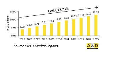
世界の高高度擬似衛星の市場規模は、2025年に39億米ドルと推定され、2035年までに129億3,000万米ドルに成長すると予測されており、予測期間の2025年~2035年の年間平均成長率(CAGR)は12.73%と見込まれています。
世界の高高度疑似衛星市場のイントロダクション
防衛用高高度擬似衛星(HAPS)市場は、永続的な空中監視、通信、情報収集システムにおける進化するフロンティアを象徴しています。ドローンと人工衛星の中間に位置するHAPSプラットフォームは成層圏で運用され、軌道衛星のような高コストをかけずに、戦略地域の継続的な監視を長期間可能にします。国防機関は、ネットワーク中心戦争やマルチドメイン作戦の重要な要素として、このシステムをますます研究しています。柔軟な展開、迅速な移動性、従来の宇宙ベースの資産と比較して低メンテナンスを提供します。リアルタイムの状況認識、国境監視、弾力性のある通信インフラに対する需要が高まる中、HAPSプラットフォームは現代の防衛エコシステムにとって不可欠なものとなりつつあります。安定した飛行プロファイルを維持しながら気象システムの上空で運用できるHAPSの能力は、平時の監視と戦闘支援活動の双方にとって戦略的資産となっています。
高高度疑似衛星市場における技術の影響:
技術の進歩はHAPSシステムの可能性を再定義し、マルチミッション防衛資産へと変貌させつつあります。軽量複合材料、太陽電池推進、自律飛行制御、エネルギー貯蔵などの技術革新により、飛行耐久時間が延長され、運用コストが削減されました。電気光学、赤外線、レーダーシステムを含む高度なセンサーペイロードの統合により、偵察能力と情報収集能力が強化されました。AIを活用した搭載データ分析により、リアルタイムの脅威検知と適応的なミッションプランニングが可能になる一方、安全な通信リンクにより、防衛ネットワーク間でのシームレスなデータ転送が保証されます。5Gと衛星通信技術の融合は、紛争環境における空中中継ノードとしての役割をさらに強化します。技術の進化に伴い、HAPSは宇宙資産と戦術的無人航空機システムとのギャップを埋める高耐久性プラットフォームとしての位置付けがますます高まっています。
高高度疑似衛星市場の主な促進要因:
いくつかの戦略的要因が防衛活動におけるHAPSの採用を促進しています。特に国境警備や海上監視では、広域での持続的な情報、監視、偵察の必要性が高まっていることが主な動機となっています。防衛軍は、従来の衛星に代わる、迅速な配備とミッションの柔軟性を提供するコスト効率の高い代替手段を求めています。ドメイン間のシームレスなデータ接続が重要なネットワーク中心作戦の比重が高まっていることも、HAPSベースの通信リレーへの関心を高めています。さらに、低排出ガスや太陽電池を動力源とするプラットフォームへのシフトは、持続可能性の目標に沿うものであると同時に、運用耐久性の延長を実現するものでもあります。地政学的緊張の高まりと、電子戦シナリオにおける弾力性のある通信インフラへの要求は、防衛機関がこれらのシステムに投資することをさらに後押ししています。これらの要因が相まって、HAPSは次世代防衛戦略にとって不可欠な存在となっています。
高高度擬似衛星市場の地域動向:
防衛用HAPS市場の地域力学は、戦略的優先順位、産業能力、防衛近代化計画の違いによって形成されています。北米では、状況支配力を高めるため、HAPSをより広範な指揮統制アーキテクチャに統合することに重点を置いて開発が進められています。欧州諸国は、従来の宇宙システムへの依存を減らすため、主権と共同研究イニシアチブを重視しています。アジア太平洋では、国境間の緊張の高まりと海洋安全保障上の課題により、固有のHAPS開発への投資が加速しています。中東諸国は、厳しい気候条件の下での持続的な国境監視やテロ対策活動のために、こうしたシステムを模索しています。一方、ラテンアメリカやアフリカの新興防衛産業は、限られた衛星アクセスを補う費用対効果の高い監視ソリューションとしてHAPSを注目しています。全体として、地域戦略は、HAPSが防衛情報と通信インフラに不可欠な層であるという認識の高まりを反映しています。
主要な高高度疑似衛星プログラム
インド海軍は、ベンガルールに拠点を置くNewSpace Research and Technologies(NRT)と、高高度疑似衛星(HAPS)の設計・開発に関する契約を締結しました。この契約は、Innovations for Defence Excellence(iDEX)イニシアティブに該当し、海軍の長距離監視能力を高めることを目的としています。昨年12月、NRTは、太陽電池を動力源とする長期耐久型HAPSが21時間の初飛行に成功したと発表しました。iDEXプログラムの下で、同社は現在、48時間を超える太陽電池による飛行を目標とする概念実証機の開発に取り組んでいます。NRTのCEOで元空軍パイロットのサミール・ジョシ氏はXで、プロトタイプが冬至の12月22日にテスト飛行を行い、このマイルストーンを達成したことを明らかにしました。
目次
高高度擬似衛星市場- 目次
高高度疑似衛星市場レポートの定義
高高度疑似衛星市場セグメンテーション
地域別
用途別
推進力別
今後10年間の高高度疑似衛星市場分析
この章では、10年間の高高度疑似衛星市場分析により、高高度疑似衛星市場の成長、変化する動向、技術採用の概要、および全体的な市場の魅力について詳細な概要が提供されます。
高高度擬似衛星市場の市場技術
このセグメントでは、この市場に影響を与えると予想される上位10の技術と、これらの技術が市場全体に与える可能性のある影響について説明します。
世界の高高度疑似衛星市場予測
この市場の10年間の高高度疑似衛星市場予測は、上記のセグメントにわたって詳細にカバーされています。
地域別高高度擬似衛星市場動向と予測
このセグメントでは、地域別の高高度擬似衛星市場の動向、促進要因、制約要因、課題、そして政治、経済、社会、技術といった側面を網羅しています。また、地域別の市場予測とシナリオ分析も詳細に取り上げています。地域分析の最終段階では、主要企業のプロファイリング、サプライヤーの情勢、企業ベンチマークなどについて分析しています。現在の市場規模は、通常のシナリオに基づいて推定されています。
北米
促進要因、抑制要因、課題
PEST
市場予測とシナリオ分析
主要企業
サプライヤー階層の情勢
企業ベンチマーク
欧州
中東
アジア太平洋
南米
高高度擬似衛星市場の国別分析
この章では、この市場における主要な防衛プログラムを取り上げ、この市場で申請された最新のニュースや特許についても解説します。また、国レベルの10年間の市場予測とシナリオ分析についても解説します。
米国
防衛プログラム
最新ニュース
特許
この市場における現在の技術成熟度
市場予測とシナリオ分析
カナダ
イタリア
フランス
ドイツ
オランダ
ベルギー
スペイン
スウェーデン
ギリシャ
オーストラリア
南アフリカ
インド
中国
ロシア
韓国
日本
マレーシア
シンガポール
ブラジル
高高度疑似衛星市場の機会マトリックス
機会マトリックスは、読者がこの市場における機会の高いセグメントを理解するのに役立ちます。
高高度疑似衛星市場レポートに関する専門家の意見
この市場の可能性のある分析についての当社の専門家の意見をお届けします。
