|
|
年間契約型情報サービス
商品コード
1765469
非GEO衛星コンステレーション解析ツールキット 5.3Non-GEO Constellations Analysis Toolkit 5.3 |
||||||
|
|||||||
| 非GEO衛星コンステレーション解析ツールキット 5.3 |
|
出版日: 年間契約型情報サービス
発行: Analysys Mason
ページ情報: 英文
|

全表示
- 概要
- 目次
非GEO衛星コンステレーション解析ツールキット(NCAT)」は、厳密なデータ駆動型分析と直感的なユーザー体験を組み合わせることで、地球低軌道(LEO)と地球中軌道(MEO)の衛星コンステレーションの客観的な評価を提供します。
NCATは、多様なデータセット、高度な分析、インタラクティブなビジュアライゼーション、AI機能を統合することで、戦略担当者、ビジネスリーダー、技術専門家に、非静止軌道(非GEO)衛星コンステレーションの能力と影響に関する信頼性の高い洞察を提供します。
ユーザーフレンドリーなオンラインWebアプリとして提供されており、帯域幅の需給動向を直感的に把握したり、市場のアドレス可能性を評価したり、ビジネスケースの感度を検証したりすることができます。また、衛星関連データや打ち上げ統計の詳細な分析も可能です。
NCATは、主要なパフォーマンス指標を自動で算出し、衛星コンステレーション同士はもちろん、地上ネットワークとの比較においてもその競争力をベンチマークします。これらすべてを、専門的な技術知識がなくてもスムーズに行えるのが特徴です。
対象範囲
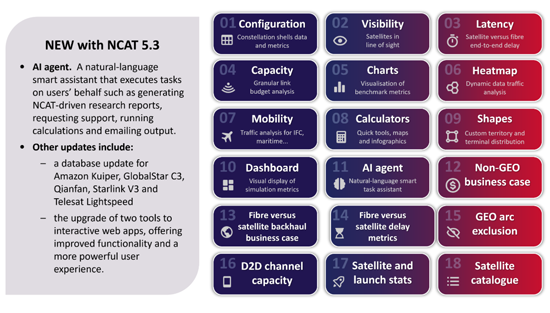
数万行のオリジナルコードと数百万件のクエリ可能なデータベースレコードによって駆動される18の統合ツールは、複数のレベルで衛星コンステレーション性能の客観的なデータ駆動型評価を提供します。何百万もの動的な計算は、設定可能なフィルター、視覚化コントロール、およびユーザー定義の入力を備えた直感的なインターフェイスを介して処理されます。すべての出力データ(データ表、チャート、ビジュアライゼーション)は、追加の分析やレポート作成に活用できるよう、簡単にダウンロード可能です。
特徴
- 厳密なコード化されたアルゴリズムにより、事実に基づいた分析とビジュアライゼーションを行います。
- 包括的で定期的に更新されるデータベース。最新のシミュレーションを実行可能に。
- デイリー更新:軌道上の衛星数と軌道観測
- ウィークリー更新(日曜):衛星カタログ
- マンスリー更新:衛星と打上げ統計
- クォータリー更新:コアソフトウェアとデータベースの機能強化
- ポイント&クリックの双方向性:インタラクティブなマップやコントロール(レイヤー、フィルター、ボタン、設定など)を簡単に操作し、数回クリックするだけで、ズームインやズームアウト、ユーザー端末の位置設定、動的な計算やビジュアライゼーションを行うことができます。
- マルチ軌道、マルチバンド解析:シミュレーションは、1つまたは複数のシステムの軌道シェルの組み合わせにわたって設定できるため、異なる周波数帯域にわたる数千の衛星の同時計算が可能。
- ダイナミックなアニメーション表示:衛星位置、カバレッジ・フットプリント、可視衛星、アンテナ・ルックアングル、リンク遅延変動、需給ヒートマップなど、主要条件のリアルタイム伝搬を表示できます。
- 時空間コントロール:NCAT5は、世界、リージョナル、ローカルスケールのリアルタイム解析と加速タイムラプス解析の両方をサポートしています。シミュレーションは最大300倍まで高速化でき、約5分で1日のコンステレーションパフォーマンスを分析できます。
- 六角形の地上グリッド:NCAT5は、国レベルの精度を持つダイナミックな六角形グリッドを採用しており、都市スケールの解像度(セル半径9km)まで設定可能。Shapes'ツールを使えば、NCATデータベースにあらかじめ登録されている250以上の国や地域以外にも、カスタム地域を定義することができます。
- IPスループットの同時計算:NCAT5は、ユーザーターミナルとゲートウェイのルックアングルの組み合わせを考慮しながら、すべてのユーザービームとゲートウェイビームでリンクバジェットのスループット解析を同時に実行します。
- 柔軟な需要モデル:あらかじめ設定された需要基準から選択したり、カスタムの需要パラメータ(ユーザー端末の分布や帯域幅需要の機能ドライバを含む)を定義して、特定の使用事例に合わせたシミュレーションを行うことができます。
- 需要主導の供給:NCATは、選択可能な公平基準に基づいて、ステアラブルビーム容量の動的再構成をシミュレートし、変化する需要条件に実現可能な供給を最適にマッチさせます。
- モビリティツール:NCATは、ユーザー定義のスケジュールを通じて、幅広いモビリティアプリケーション(機内Wi-Fi、鉄道、海上、コネクテッドカーなど)をサポートします。さらにNCATは、何万ものルート、航空会社、空港をカバーするリアルタイムの商用フライトデータを統合し、機内接続(IFC)の需給ダイナミクスを評価します。
- 統計:NCAT5は、包括的なカタログデータと衛星打ち上げ統計にアクセスして処理し、1957年以降に宇宙に打ち上げられた未分類の61,000以上の物体のデータを検索するための設定可能なフィルターをユーザーに提供します。
- レポート作成:AIエージェントツールは、自然言語を使用してNCAT内部のツールやデータセットとシームレスに対話し、クエリへの回答、専門的なレポートの作成、シミュレーション結果の解釈を可能にします。
- ダウンロード可能なチャートとデータ:すべてのチャート、マップ、インフォグラフィックは、PDFまたはPNG形式でダウンロードできます。出力データは表形式のCSV形式で利用でき、プラットフォーム外でのさらなる分析が可能です。ダウンロード可能なコンテンツには、表、チャートデータ、地図、ベンチマーク指標、タイムスタンプ付きサンプル、需給データ付き地上グリッド、評価サマリー、飛行ルート、ルックアングル統計、ビーム利用率などが含まれています。
アプリケーション |
NCATは衛星通信(satcom)に焦点を当てていますが、地球観測(EO)や全地球航法衛星システム(GNSS)を評価する機能も含まれています。 |
ツール |
18の設定可能なツールにより、以下のような多角的な分析およびベンチマークが可能:
|
コンステレーションシェル: |
100以上の運用中、計画中、提出済みのシステムを収録(ユーザーによる編集・拡張が可能) |
ゲートウェイ: |
370以上の調査済みゲートウェイ・ロケーション(ユーザーによる編集・拡張が可能) |
地理的地域: |
250以上の国、地域、リージョン、サブリージョンが含まれます(ユーザーによる編集・拡張が可能) |
よくある質問への対応
- 現在および将来のNGSOアーキテクチャのカバレッジ、容量、ビーム、衛星のベンチマークは?
- ゲートウェイ、ユーザービーム、衛星ごとに、フォワードリンクおよびリターンリンクの容量(スペクトル、帯域幅、IPスループット)はどのくらいか?
- 国や地域ごとに、同時に何人のユーザーをサポートできるか?
- 使用可能な毎秒メガビットあたりの資本コストはどのように決定できるのか?
- 宇宙船の製造コストや打ち上げコストに対するビジネスケースの感度は?
- 衛星通信コンステレーションは、十分なサービスが提供されていない地域において、どのような場合に光ファイバーよりも優れた性能を発揮するのか?
- バックホールの設備投資と固定費はビジネスケースにどのように影響するのか?
- 設定可能なサービスプランに基づいて、帯域幅の需給をどのように評価できるか、また混雑のホットスポットはどこか?
- 緯度や軌道シェルの違いによる衛星の最大数、平均数、最小数は?
- POP、光衛星間リンク(OISL)、リンク・リレーを考慮した場合、ファイバーの遅延はLEOシステムの遅延とどう比較されるのか?
- GEO干渉を避けるための非GEOシステムの規制除外角度は?
本ツールの対象ユーザー:
- 衛星運用者(GEO、非GEO、FSS、MSS/D2D)
- 衛星メーカーおよび部品ベンダー
- 地上/無線ネットワーク事業者(通信事業者、MNO、ISP、タワーコス、クラウドサービスプロバイダーなど)
- 地上システムベンダー(端末、アンテナ、ハブ/モデム、SD-WAN)
- テレポートオペレーター、衛星サービスプロバイダー、GEO-非GEOインテグレーター
- 主要な非GEO容量ユーザー(政府、防衛関係者、航空会社、エネルギー会社など)
- 業界団体、研究所、研究機関
- 仮想コンステレーション・ソフトウェアを開発するIT企業
- 規制当局および周波数調査機関
- 金融機関、投資会社
含まれる衛星システム(例)
|
|
NCATはオンラインで設定可能なツールセットとして、無制限の利用が可能です。また、許認可済み、運用中、計画中の主要な非GEO衛星システムのデータセットをあらかじめ搭載して提供されます。
The 'Non-GEO Constellations Analysis Toolkit (NCAT)' combines rigorous, data-driven analysis with an intuitive user experience to deliver objective assessments of low-Earth orbit (LEO) and medium-Earth orbit (MEO) satellite constellations.
NCAT equips strategists, business leaders and technical professionals with reliable insights into the capabilities and impact of non-geostationary (non-GEO) constellations by integrating diverse datasets, advanced analytics, interactive visualisations and AI capabilities.
NCAT is delivered as a user-friendly online web app, and empowers users to seamlessly explore bandwidth supply and demand dynamics, assess market addressability, evaluate business case sensitivities and delve into satellite data and launch statistics. The platform automatically calculates key performance metrics and benchmarks the competitiveness of satellite constellations (both against each other and relative to terrestrial networks), all without requiring deep technical expertise.
Toolkit coverage
18 integrated tools, driven by tens of thousands of lines of original code and millions of queryable database records, provide objective, data-driven assessments of constellation performance at multiple levels. Millions of dynamic calculations are processed via an intuitive interface with configurable filters, visualisation controls and user-defined inputs. All outputs (data tables, charts and visualisations) are easily downloadable for further analysis or reporting.
Features included:
- Rigorously coded algorithms that drive factual analytics and visualisations.
- A comprehensive, regularly updated database. This enables users to run up-to-date simulations.
- Daily: in-orbit satellite counts and orbital observations are updated automatically every day.
- Weekly: the satellite catalogue is updated automatically each Sunday.
- Monthly: satellite and launch statistics are refreshed automatically every month.
- quarterly: core software and database enhancements are deployed every quarter.
- Point-and-click interactivity. Users can easily navigate interactive maps and controls (such as layers, filters, buttons and settings) to zoom in and out, set user terminal locations and drive dynamic calculations and visualisations with just a few clicks.
- Multi-orbit, multi-band analysis. Simulations can be configured across combinations of orbital shells from one or multiple systems, thus enabling concurrent calculations for thousands of satellites across different frequency bands.
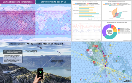
- Dynamic, animated visualisations. Users can view real-time propagation of key conditions, including satellite positions, coverage footprints, visible satellites, antenna look angles, link latency variations and supply-demand heatmaps.
- Space-time controls. NCAT5 supports both real-time and accelerated time-lapse analysis at global, regional or local scales. Simulations can be sped up by up to 300x, enabling users to analyse a full day of constellation performance in around 5 minutes.
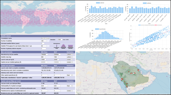
- Hexagonal ground grid. NCAT5 employs a dynamic hexagonal grid with country-level precision, configurable down to city-scale resolution (~9 km cell radius). The 'Shapes' tool enables users to define custom geographical areas beyond the 250+ countries and regions preloaded in the NCAT database.
- Concurrent IP throughput computations. NCAT5 performs concurrent link-budget throughput analysis across all user and gateway beams, accounting for combinations of user-terminal and gateway look angles.
- Flexible demand models. The toolset enables users to choose from pre-set demand criteria or define custom demand parameters (including user terminal distribution and functional drivers of bandwidth demand) to tailor simulations to specific use cases.
- Demand-driven supply. NCAT simulates dynamic reconfigurations of steerable beam capacity based on selectable fairness criteria to optimally match feasible supply with changing demand conditions.
- Mobility tool. NCAT supports a wide range of mobility applications (such as in-flight Wi-Fi, rail, maritime and connected vehicles) through user-defined schedules. Additionally, NCAT integrates real-time commercial flight data, covering tens of thousands of routes, airlines and airports, to assess in-flight connectivity (IFC) supply and demand dynamics.
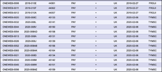
- Statistics. NCAT5 accesses and processes comprehensive catalogued data and satellite launch statistics, presenting users with configurable filters to explore data for over 61 000 unclassified objects launched into space since 1957.
- Report generation. The AI Agent tool uses natural language to interact seamlessly with internal NCAT tools and datasets, enabling it to answer queries, generate professional reports and interpret simulation results.
- Downloadable charts and data. All charts, maps and infographics can be downloaded in PDF or PNG format. Output data is available in tabular CSV format, enabling further analysis outside the platform. Downloadable content includes tables, chart data, maps, benchmark metrics, time-stamped samples, terrestrial grids with supply and demand data, assessment summaries, flight routes, look angle statistics, beam utilisation and more.
Applications: |
NCAT is focused on satellite communications (satcom) but includes features to assess Earth observation (EO) and global navigation satellite systems (GNSS). |
Tools: |
18 configurable tools to analyse and benchmark systems from multiple angles, including:
|
Constellation shells: |
100+ operational, planned and filed systems included (user editable and expandable). |
Gateways: |
370+ surveyed gateway locations (user editable and expandable). |
Geographical regions: |
250+ countries, territories, regions and subregions included (user editable and expandable). |
Questions answered:
- How do current and future NGSO architectures benchmark across coverage, capacity, beam, and satellites?
- What is the forward and return link capacity (spectrum, bandwidth and IP throughput) per gateway, user beam and satellite?
- How many users can constellations support simultaneously, by country or territory?
- How can the capital cost per usable megabits per second be determined?
- What is the business-case sensitivity to spacecraft manufacturing and launch costs?
- When can satcom constellations outperform fibre-optics in underserved communities?
- How does backhaul capex and opex affect the business case?
- How can bandwidth supply and demand be assessed, based on configurable service plans, and where are the congestion hotspots?
- What is the maximum, average and minimum number of satellites in view or line of sight at different latitudes and orbital shells?
- How does fibre latency compare with that of LEO systems, factoring in POPs, optical inter-satellite links (OISLs) and link relays?
- What are the regulatory exclusion angles for non-GEO systems to avoid GEO interference?
Who should use this toolbox:
- Satellite operators (GEO, non-GEO, FSS and MSS/D2D)
- Spacecraft manufacturers and component vendors
- Terrestrial/wireless network operators (telecoms operators, MNOs, ISPs, towercos, cloud services providers and so on)
- Ground system vendors (terminals, antennas, hub/modems and SD-WAN)
- Teleport operators, satellite service providers and GEO-non-GEO integrators
- Major non-GEO capacity users (such as governments, defence players, airlines and energy companies)
- Industry associations, research labs and institutions
- IT companies developing virtualised constellation software
- Regulators and spectrum research agencies
- Financial institutions and investment firms
Satellite systems included (examples):
|
|
As an online configurable toolset, NCAT has unlimited usability and is delivered pre-populated with datasets for leading non-GEO systems, including granted, operating and proposed systems.