
|
市場調査レポート
商品コード
1687955
エアリアルイメージング:市場シェア分析、産業動向・統計、成長予測(2025年~2030年)Aerial Imaging - Market Share Analysis, Industry Trends & Statistics, Growth Forecasts (2025 - 2030) |
||||||
カスタマイズ可能
適宜更新あり
|
|||||||
| エアリアルイメージング:市場シェア分析、産業動向・統計、成長予測(2025年~2030年) |
|
出版日: 2025年03月18日
発行: Mordor Intelligence
ページ情報: 英文 166 Pages
納期: 2~3営業日
|

全表示
- 概要
- 目次
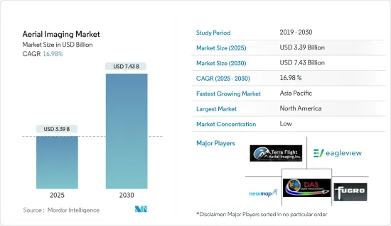
エアリアルイメージングの市場規模は2025年に33億9,000万米ドルと推定・予測され、2030年には74億3,000万米ドルに達すると予測され、予測期間(2025-2030年)のCAGRは16.98%です。
エアリアルイメージングとそのビデオ画像への進化は、30年以上にわたってさまざまな小型航空プラットフォームを使って撮影されてきました。ラジコン模型飛行機、小型35mm一眼レフを使用するヘリコプター、軽量ビデオカメラなどの小型プラットフォームは、カラー、パンクロマチック、カラー赤外(CIR)、マルチスペクトルエアリアルイメージングの取得に使用され、幅広い用途に使用されてきました。
市場は、RTF(Ready-to-Fly)デバイス、ソフトコピー写真測量ソフトウェア、低価格デジタルカメラ、画像処理、GPS、サーマル、マルチスペクトル、ハイパースペクトル、LiDARセンサーの技術開拓によって増強されてきました。UAVは、小面積の調査用に高解像度の写真や4Kビデオのデータセットを取得する高度な手段となっています。
エアリアルイメージングはGPSを使用し、正確な位置特定を支援します。例えば、農家はGPSを利用して農作物の健康状態を監視し、問題箇所を特定し、肥料を散布します。エネルギーや電力用地の管理は、天候による損傷を修復し、より正確に目標を定めることができるため、エアリアルイメージングの精度の恩恵を受ける。
警察もエアリアルイメージングを使って作成された地図を利用しています。同署では、必需品の移動、物理的な距離の目印の設置、労働力の割り当て、隔離センターの設置場所の決定、ホットスポットから近隣の病院や警察署への目印、緊急時に移動しやすい最短ルートなどに使用しています。
COVID-19の大流行により、エアリアルイメージングの需要が高まっています。この画像は、ウイルスの経済的影響を調査し、インフラや施設を遠隔監視するために使用されます。政府、エネルギー、電力、石油・ガスなど様々な業界からの需要が増加しました。また、パンデミックのピーク時には、画像でサプライチェーンの状況を監視しました。
ドローン測量の動向はすでに主流になりつつあるが、パンデミックはそのスケールを大きく傾けた。UAVは非接触でタスクを遂行できるため、COVID-19のパンデミック時に頼りになるテクノロジーとなりました。UAVは、病院やCOVID-19試験センターを建設できる地域の調査や地図作成、そうした場所の監視に重要な役割を果たしています。
エアリアルイメージング市場の動向
政府がエアリアルイメージングの最大のエンドユーザーになる見込み
エアリアルイメージングは、様々な自治体、州、連邦政府の計画アプリケーションに不可欠となっています。また、地図作成プロセスにも欠かせないものとなっています。エアリアルイメージングは、その場所の物理的、文化的環境を特定の瞬間に反映します。
これらのエアリアルイメージングが適切に理解されれば、地理学者、歴史家、生態学者、地質学者、都市計画家、考古学者、その他の専門家にとって、調査にとって重要な図像の基礎となります。弁護士は、所有権紛争、水利権、交通権に関わる問題を判断するために、エアリアルイメージングを利用することが多くなっています。最近では、系図学者が先祖の場所を発見し見つけるためにエアリアルイメージングを使用しています。
政府のドローン利用は、ドローンプロジェクトやアプリケーションを持つ部署の数により急速に増加しています。野心的な政府組織や部署は、交通や公共事業から計画や環境サービスに至るまで、新たな職域で実験を行っています。
米国政府は、戦場に配備される可能性のある新兵器の実験を行っています。戦場で優位に立つことは、戦争の存続と成功に欠かせないです。無人航空機(UAV)は、前世紀とは言わないまでも、ここ数十年の軍事紛争において最も重要な発明です。
例えば、米国地質調査所のアッパー・ミッドウエスト環境科学センターは最近、海洋エネルギー管理局および米国魚類野生生物局と提携しました。カリフォルニア大学バークレー校の国際コンピューター科学研究所のビジョン・グループは、デジタルエアリアルイメージングからウミガモやその他の海洋生物を自動的に識別、列挙、分類、注釈するためのディープラーニング・アルゴリズムとツールを作成します。
自覚の有無にかかわらず、ほとんどの人がエアリアルイメージングを利用しています。エアリアルイメージングは、Google ImagesやGoogle Earthのような基本的な用途から、犯罪を減らすためにエアリアルイメージングを利用する警察機関のような複雑な用途まで、あらゆる規模や分野の個人や組織の時間と費用の節約に役立つ可能性があります。
空撮による水鳥の個体数調査は、捕獲やその他の規制の決定、環境評価、米国における海洋エネルギー開発プロジェクトにおける野生生物への影響予測に影響を与えることができます。大西洋外大陸棚と五大湖の航空機調査で収集された高解像度デジタル画像は、アルゴリズム開発のためのデータと、動物の分布と豊度に関するベースライン情報を提供します。
エアリアルイメージングは、政府、専門的な対応・復旧組織、地域社会、および人々が、予想される差し迫った、または実際に発生した危険の結果や状況を予測し、対応し、回復するのに役立ちます。多くの政府部門でエアリアルイメージングの利用が増加していることから、世界的にエアリアルイメージングの需要が高まっています。
北米が大きな市場シェアを占める
北米は、この地域の企業による高度な調査と、この地域のエンドユーザー産業における技術採用の増加により、調査市場の主要な投資家および採用者の1つとなっています。
エアリアルイメージングは、正投影画像から取得した空間データを使用して、土地被覆、植生、土壌、地質図の情報を抽出します。また、内陸や不動産情報、考古学、環境調査、災害・緊急対応管理など、政府ベースのアプリケーションにも使用されています。そして、エアリアルイメージングは、地表を正確に表現するために重要な計画、地図、予報の開発に使用されます。また、エアリアルイメージングは、エンジニア、プランナー、開発者の間で、土地のマッピングや開発で脚光を浴びています。
市場の拡大は、災害管理、軍事、林業、都市計画アプリケーションにおけるエアリアルイメージングプラットフォームの採用増加を促進する主な要因です。エアリアルイメージングとマッピングプラットフォームの使用は、道路計画や不動産管理における都市計画者の間で拡大しており、土地利用計算に使用されています。同地域では、主要なエアリアルイメージングソリューションプロバイダーがAIや機械学習技術を活用した新製品開発に注力しているため、エアリアルイメージングプラットフォームの普及が進んでいます。
また、北米の農業は主に工業化され、アグリビジネスを支援する統合システムに依存するようになったが、メキシコでは独自の伝統がまだ実践されています。米国とカナダのほとんどの農家は、主にテクノロジーに依存しています。テクノロジー企業は、センサー、圃場内カメラ、ドローンや飛行機による空撮画像、衛星画像データなど、複数のデータソースを通じて農家に洞察を提供することに取り組んできました。これらの画像データソースは、強力なコンピューティングリソース、膨大なデータストレージ機能、洞察を得るための時間を必要とします。
さらに、同地域の建設活動では、エアリアルイメージングの需要が継続的に増加しています。例えば、ドローン技術を使えば、現場のエンジニアは仕事の進捗状況を追跡し、これらの不整合をより効率的に監視できます。
さらに、米国政府が歴史的なインフラ整備法案を提出したことで、建設業界は、建設業界に対する政府支出の増加による投資の大幅な増加に備えています。道路、橋、その他の重要なインフラ・プロジェクトに1,100億米ドルが確保されたことで、請負業者や測量士は、国内のさまざまな土木建設プロジェクトを監督するために大きな需要が見込まれます。
技術の利用の拡大や、現場エリアの検査、監視、モニタリングのための技術の利点に対する需要を後押ししている政府建設プロジェクトの数といった要因が、市場成長の重要な理由です。
エアリアルイメージング産業の概要
エアリアルイメージング市場は細分化されており、多くの業界プレーヤーが市場の可能性を探っています。この業界のマーケティングと広告レベルも成長しており、企業集中率は中程度で成長しています。主な参入企業には、Terra Flight Aerial Imaging Inc.、Fugro Ltd.、Nearmap Ltd.、Eagle View Technologies Inc.、Digital Aerial Solutions LLCなどがあります。
2023年2月- オンダスは、完全子会社であるアメリカンロボティクスとアイロボティクスの統合ドローン事業を統括するオンダス・オートノマス・システムズの設立を発表。鉄道、エネルギー、鉱業、農業、公共安全、重要インフラ、政府市場において、Ondas NetworksとOndas Autonomous Systemsは、接続、データ収集能力、データ収集・情報処理能力の向上をユーザーに提供。
2024年4月- インフラソリューションに特化した全国的なエンジニアリングサービス会社であるBowman Consulting Group Ltdは、地理空間およびエンジニアリングサービスで知られ、様々な高度でのデジタルオルソ画像、LiDAR技術、デジタルマッピング、水路図、災害マッピングを提供するSurdex Corporationを買収することで最終合意。もともとはエアリアルイメージング会社であったが、デジタル画像と地図作成へと発展しました。同社は、単発機、双発機、無人航空機(UAV)を含む10機の航空機を保有し、公共および民間セクターのクライアントの地理空間ニーズへの対応を可能にしています。
その他の特典:
- エクセル形式の市場予測(ME)シート
- 3ヶ月間のアナリスト・サポート
目次
第1章 イントロダクション
- 調査の前提条件と市場定義
- 調査範囲
第2章 調査手法
第3章 エグゼクティブサマリー
第4章 市場洞察
- 市場概要
- 産業バリューチェーン分析
- 業界の魅力度-ポーターのファイブフォース分析
- 供給企業の交渉力
- 買い手の交渉力
- 新規参入業者の脅威
- 代替品の脅威
- 競争企業間の敵対関係の強さ
- COVID-19の業界への影響評価
第5章 市場力学
- 市場促進要因
- 位置情報サービスの台頭
- 多様化するアプリケーションからの需要増加
- 市場抑制要因
- セキュリティとプライバシーの問題
- 厳しい政府規制
第6章 市場セグメンテーション
- プラットフォームタイプ別
- 固定翼機
- ヘリコプター
- UAV/ドローン
- その他のプラットフォームタイプ
- 用途別
- 地理空間マッピング
- インフラ計画
- 資産目録管理
- 環境モニタリング
- 国家および都市マッピング
- 監視・モニタリング
- 災害管理
- その他のアプリケーション
- エンドユーザー産業別
- 建設
- 航空宇宙・防衛
- 政府機関
- 石油・ガス
- エネルギー・電力
- 農業
- その他のエンドユーザー産業
- 地域別
- 北米
- 欧州
- アジア太平洋
- 世界のその他の地域
第7章 競合情勢
- 企業プロファイル
- Terra Flight Aerial Imaging Inc.
- Fugro Ltd
- Nearmap Ltd
- Eagle View Technologies Inc.
- Digital Aerial Solutions LLC
- Dronegenuity
- Cooper Aerial Surveys Co.
- Landiscor Real Estate Mapping
- Kucera International Inc.
- GeoVantage Inc.(Aeroptic LLC)
- Global UAV Technologies Ltd(High Eye Aerial Imaging Inc.)
- Eagle Aerial Solutions
- Aerobotics,(Pty)Ltd
- Airobotics GmbH(ONDAS Holdings)
- SkyIMD Inc.
第8章 投資分析
第9章 市場の将来
The Aerial Imaging Market size is estimated at USD 3.39 billion in 2025, and is expected to reach USD 7.43 billion by 2030, at a CAGR of 16.98% during the forecast period (2025-2030).
Aerial imaging and its evolution into video imagery have been captured using various small aerial platforms for over three decades. Small-scale platforms such as radio-controlled model aircraft, helicopters that use small 35 mm SLR, and light-weighted video cameras have been used to acquire color, panchromatic, color infrared (CIR), and multispectral aerial photography for a wide range of applications.
The market has been augmented by the technology development of ready-to-fly (RTF) devices, soft-copy photogrammetry software, low-cost digital cameras, image processing, GPS, thermal, multispectral, hyperspectral, and LiDAR sensors. UAVs have become a sophisticated means of acquiring high-resolution photographic and 4K video datasets for small-area coverage studies.
Aerial imaging uses GPS, which aids in precise location. For instance, farmers use GPS targeting to monitor the health of the crops, identify problem areas, and spray fertilizer. Energy and power site management benefits from the precision of aerial imaging, as it can be repaired from weather damages and targeted more accurately.
Police departments also use maps that are being created using aerial imagery. The department uses it for the movement of essential items, placing physical distancing markers, workforce allocation, deciding where to set up isolation centers, marking nearby hospitals and police stations from hotspots, and the shortest routes for easy movement in an emergency.
The COVID-19 pandemic has led to increased demand for aerial imagery. This imagery is used to study the virus's economic impact and remotely monitor infrastructure and facilities. The demand increased from various industries, including government, energy, power, oil, and gas. Also, the imagery monitored supply chain situations during the pandemic's peak.
Although the trend of drone surveying is already becoming mainstream, the pandemic tipped the scale in its favor substantially. UAVs have become a go-to technology during the COVID-19 pandemic because they can accomplish tasks without contact. They have played a crucial role in surveying and mapping areas where hospitals and COVID-19 test centers can be built and monitoring such sites.
Aerial Imaging Market Trends
The Government is Expected to be the Largest End User of Aerial Imaging
Aerial imaging has become vital for various municipal, state, and federal government planning applications. It has also become an integral aspect of the mapmaking process. Aerial images reflect a location's physical and cultural environment at a particular moment.
When properly understood, these aerial photographs give geographers, historians, ecologists, geologists, urban planners, archaeologists, and other experts a graphical foundation that is frequently important to their research. Lawyers increasingly use aerial photography to decide matters involving property disputes, riparian rights, and transportation rights-of-way. Recently, genealogists have employed aerial photography to discover and find ancestral locations.
Government drone use is quickly rising due to the number of departments with drone projects and applications. Ambitious government organizations and departments are experimenting with new job areas, from transportation and public works to planning and environmental services.
The US government has experimented with new weaponry that may be deployed on the battlefield. Gaining an edge on the battlefield is crucial to a war's survival and success. Uncrewed aerial vehicles (UAVs) have been the most significant invention in military conflict in recent decades, if not the preceding century.
For example, the United States Geological Survey's Upper Midwest Environmental Sciences Center has recently partnered with the Bureau of Ocean Energy Management and the US Fish and Wildlife Service. The Vision Group at the International Computer Science Institute at the University of California, Berkeley, will create deep learning algorithms and tools for the automatic identification, enumeration, categorization, and annotation of sea ducks and other marine creatures from digital aerial imagery.
Most individuals utilize aerial images, whether they realize it or not. Aerial imagery may help individuals and organizations of all sizes and sectors save time and money, from basic applications like Google Images or Google Earth to complicated applications like police agencies using it to reduce crime.
Airborne waterfowl population surveys can influence harvest and other regulatory decisions, environmental evaluations, and impact estimates of prospective wildlife exposure to offshore energy development projects in the United States. High-resolution digital images collected during aircraft surveys of the Atlantic Outer Continental Shelf and the Great Lakes will provide data for algorithm development and baseline information on animal distributions and abundance.
Aerial pictures can help governments, professional response and recovery organizations, communities, and people anticipate, respond to, and recover from the consequences of expected imminent or actual hazard occurrences or circumstances. The increasing aerial photography usage in many government sectors has increased the demand for aerial pictures worldwide.
North America to Hold a Significant Market Share
North America is one of the major investors and adopters of the studied market due to the high level of research done by the regional companies and the increasing adoption of the technologies among the regional end-user industries.
Aerial imaging extracts information on land cover, vegetation, soil, and geology maps using spatial data captured from orthographic images. It is also used in government-based applications such as inland and property information, archaeology, environment studies, and disaster and emergency response management. Aerial imaging is then used to develop plans, maps, and forecasts crucial for accurately presenting the Earth's surface. Also, aerial imaging is gaining prominence among engineers, planners, and developers in land mapping and development.
Market expansion is the primary factor driving the increased adoption of aerial imaging platforms in disaster management, military, forestry, and urban planning applications. The use of aerial imaging and mapping platforms is growing among urban planners in road planning and real estate management, and they are used in land use calculations. The region exhibits a strong uptake of aerial imaging platforms due to major aerial imaging solution providers focusing on new product developments powered by AI and machine learning technologies.
In addition, agriculture in North America has become chiefly industrialized and reliant on an integrated system of supporting agribusinesses; however, original traditions are still practiced in Mexico. Most farmers in the United States and Canada rely primarily on technology. Technology companies have been working to provide insights to farmers through multiple data sources, including sensors, in-field cameras, aerial imagery gathered by drones and airplanes, and satellite imagery data. These imagery data sources require powerful computing resources, massive data storage capabilities, and time to generate insights.
Moreover, the demand for aerial imaging in the region's construction activity is increasing continuously. For instance, with drone technology, field engineers can track job progress and monitor these inconsistencies more efficiently.
Additionally, with the US government's historic infrastructure bill, the construction industry braced for a substantial boost in investment by increasing government spending on the construction industry. Contractors and surveyors are expected to be in great demand to oversee various civil construction projects around the country, with USD 110 billion set aside for roads, bridges, and other significant infrastructure projects.
Factors such as the growing use of technologies and the number of government construction projects that have boosted the demand for the benefits of technologies for the inspection, monitoring, and surveillance of the site area are critical reasons for the market's growth.
Aerial Imaging Industry Overview
The aerial imaging market is fragmented, with many industry players exploring the market potential. This industry's marketing and advertising level is also growing, while the firm concentration ratio is moderate and growing. Some of the major players in the market are Terra Flight Aerial Imaging Inc., Fugro Ltd, Nearmap Ltd, Eagle View Technologies Inc., and Digital Aerial Solutions LLC.
February 2023 - Ondas announced the creation of Ondas Autonomous Systems to oversee the integrated drone operations of wholly owned subsidiaries American Robotics and Airobotics. In the rail, energy, mining, agricultural, public safety, critical infrastructure, and government markets, Ondas Networks and Ondas Autonomous Systems provide users with increased connection, data gathering capabilities, and data collection and information processing capabilities.
April 2024 - Bowman Consulting Group Ltd, a national engineering services firm specializing in infrastructure solutions, finalized an agreement to acquire Surdex Corporation, known for its geospatial and engineering services, offering a range of digital ortho imagery at various altitudes, LiDAR technology, digital mapping, hydrography, and disaster mapping. Originally an aerial photography company, Surdex has evolved into digital imagery and mapping. The company boasts a fleet of ten aircraft, including single- and twin-engine models and unmanned aerial vehicles (UAVs), enabling them to cater to the geospatial needs of public and private sector clients.
Additional Benefits:
- The market estimate (ME) sheet in Excel format
- 3 months of analyst support
TABLE OF CONTENTS
1 INTRODUCTION
- 1.1 Study Assumptions and Market Definition
- 1.2 Scope of the Study
2 RESEARCH METHODOLOGY
3 EXECUTIVE SUMMARY
4 MARKET INSIGHTS
- 4.1 Market Overview
- 4.2 Industry Value Chain Analysis
- 4.3 Industry Attractiveness - Porter's Five Forces Analysis
- 4.3.1 Bargaining Power of Suppliers
- 4.3.2 Bargaining Power of Buyers
- 4.3.3 Threat of New Entrants
- 4.3.4 Threat of Substitute Products
- 4.3.5 Intensity of Competitive Rivalry
- 4.4 Assessment of Impact of COVID-19 on the Industry
5 MARKET DYNAMICS
- 5.1 Market Drivers
- 5.1.1 Rise of Location-based Services
- 5.1.2 Increasing Demand from Diversified Applications
- 5.2 Market Restraints
- 5.2.1 Security and Privacy Issues
- 5.2.2 Stringent Government Regulations
6 MARKET SEGMENTATION
- 6.1 By Platform Type
- 6.1.1 Fixed-wing Aircraft
- 6.1.2 Helicopters
- 6.1.3 UAVs/Drones
- 6.1.4 Other Platform Types
- 6.2 By Application
- 6.2.1 Geospatial Mapping
- 6.2.2 Infrastructure Planning
- 6.2.3 Asset Inventory Management
- 6.2.4 Environmental Monitoring
- 6.2.5 National and Urban Mapping
- 6.2.6 Surveillance and Monitoring
- 6.2.7 Disaster Management
- 6.2.8 Other Applications
- 6.3 By End-user Industry
- 6.3.1 Construction
- 6.3.2 Aerospace and Defense
- 6.3.3 Government
- 6.3.4 Oil and Gas
- 6.3.5 Energy and Power
- 6.3.6 Agriculture
- 6.3.7 Other End-user Industries
- 6.4 By Geography
- 6.4.1 North America
- 6.4.2 Europe
- 6.4.3 Asia-Pacific
- 6.4.4 Rest of the World
7 COMPETITIVE LANDSCAPE
- 7.1 Company Profiles
- 7.1.1 Terra Flight Aerial Imaging Inc.
- 7.1.2 Fugro Ltd
- 7.1.3 Nearmap Ltd
- 7.1.4 Eagle View Technologies Inc.
- 7.1.5 Digital Aerial Solutions LLC
- 7.1.6 Dronegenuity
- 7.1.7 Cooper Aerial Surveys Co.
- 7.1.8 Landiscor Real Estate Mapping
- 7.1.9 Kucera International Inc.
- 7.1.10 GeoVantage Inc. (Aeroptic LLC)
- 7.1.11 Global UAV Technologies Ltd (High Eye Aerial Imaging Inc.)
- 7.1.12 Eagle Aerial Solutions
- 7.1.13 Aerobotics, (Pty) Ltd
- 7.1.14 Airobotics GmbH (ONDAS Holdings)
- 7.1.15 SkyIMD Inc.

