|
市場調査レポート
商品コード
1686526
モバイルマッピングシステム:市場シェア分析、産業動向、成長予測(2025年~2030年)Mobile Mapping Systems - Market Share Analysis, Industry Trends & Statistics, Growth Forecasts (2025 - 2030) |
||||||
カスタマイズ可能
適宜更新あり
|
|||||||

| モバイルマッピングシステム:市場シェア分析、産業動向、成長予測(2025年~2030年) |
|
出版日: 2025年03月18日
発行: Mordor Intelligence
ページ情報: 英文 125 Pages
納期: 2~3営業日
|

- 全表示
- 概要
- 目次
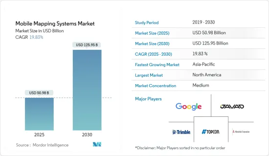
モバイルマッピングシステム市場規模は2025年に509億8,000万米ドルと推定され、予測期間(2025年~2030年)のCAGRは19.83%で、2030年には1,259億5,000万米ドルに達すると予測されます。
衛星地図技術が急速に受け入れられ、スマートフォンやモノのインターネット(IoT)接続機器にシームレスに統合されたことが、市場成長の原動力となっています。
スマートシティは、世界の都市化の進展と政府のイニシアティブにより急速に拡大しました。スマートシティは、3D地図があって初めて成立します。3D都市モデリング、自律的ナビゲーション、交通、災害管理、道路財産のデジタル化、汚染削減のサポートにより、スマートシティ向けモバイル地図技術は、資源の最適化と持続可能性の維持による生活の質の向上を目指しています。スマートフォンとインターネットの利用は、データの管理とアクセスにおいて重要な役割を果たしています。
さらに、環境モニタリングのためのモバイルナビゲーション地理情報システム(GIS)は、環境モニタリングにおいてますます利用されるようになっています。環境研究者は、暴風雨やハリケーンの予測や監視に役立つモバイルマッピングGISツールを採用しています。NASAが資金提供する生態系モニタリングと天然資源管理に関する研究プロジェクトは、モバイルマッピング分野の収益成長を牽引しています。
モバイルマッピングシステムは、歩行者ナビゲーションのための屋内地図の開発、自律走行車のための高精細(HD)地図、資産・インフラ管理、航空測量、パイプライン測量、水路測量、浚渫、海上測位・掘削作業など、さまざまな用途に使用されています。
オンデマンドの展開システムの出現は、モバイルマッピング市場の変曲点であり、高い柔軟性と精度を低い初期費用で提供する(ユーザーは月/四半期ベースで課金される)。各社は、永続的なユーザーライセンスの必要性に対抗するため、サブスクリプションベースのモデルを提供しています。
COVID-19のパンデミックは、IT業界の急速な再編成をもたらし、企業はリモート労働にシフトしました。パンデミックの間、モバイルマッピング市場は大きく成長しました。いくつかの企業や機関は、モバイルマッピング・データを可視化や地理空間分析に使用し、病気の蔓延を制限しました。地理空間データの表示にはダッシュボードが使われました。これらのダッシュボードやアプリケーションの中には、ほぼリアルタイムでデータの変更を受け取るものもありました。
モバイルマッピングシステムの市場動向
イメージング・サービス・セグメンテーションが市場を席巻
- 衛星画像とGISシステムにより、治安当局や法執行機関は、犯罪マッピングのためのホットスポットやその他の動向やパターンを特定することができます。犯罪の空間的な集中を正確に検出し、犯罪発生場所をタイムリーにマッピングすることで、法執行機関は犯罪の集中を空間的・時間的に特定し、犯罪削減の取り組みに重要な情報を提供することができます。
- このような画像は、国勢調査の人口統計や店舗、銀行、学校の位置など、他のデータセットと重ね合わせることができるため、このアプリケーションにおける分析の効率化とスピードアップに役立ちます。これにより、警備部門の管理者は犯罪の根本的な原因を理解し、戦略を立てることができます。こうした戦略には、警察官の配置や緊急時の派遣などが含まれます。
- しかし、データフュージョン、エンハンスメント、ジオリファレンス、モザイキング、カラーとグレースケールのバランシングによって画像を鮮明化する機能とともに、カラーおよびパンクロマチック画像処理サービスを提供できる高度なリモートセンシング技術に対する需要が増加しています。
- さらに、現在の市場開拓は水域の監視を目的としています。例えば、違法漁業や密売の課題から、海洋の異常を発見する必要性が生じた。Nature Ecology &Evolutionの研究者によると、西太平洋や中部太平洋など一部の地域では、違法漁業が漁業全体の30%を占める可能性があるといいます。
- 国連食糧農業機関(FAO)の統計は、無報告・無規制(IUU)漁業の世界の影響を強調しています。世界のIUU漁業は、年間漁獲量2,600万トン(100億~230億米ドル相当)に上ると推定されています。DigitalGlobeとPlanetは、このような違法行為を特定するプロジェクトで協力しました。このパートナーシップは、漁業の違法な積み替えを発見することを目的としています。
アジア太平洋が急成長
- アジア太平洋の市場は、予測期間中に著しい速度で拡大すると予想されます。衛星画像に対する政府の取り組みが増加していることが、製品の発売とともに国内外の企業からの投資を引き付けており、同地域の市場の成長を牽引しています。
- 2022年3月、オーストラリアを拠点とする独立系ドローンマッピングビジネスのEmesent社は、最新のHovermap ST自律型ドローンLiDARマッピングおよび測量ペイロードのリリースを発表しました。エメセントのLiDARペイロードは、同時定位マッピング(SLAM)として知られる技術を使用しており、ドローンは地図を作成すると同時に、その地図内で自分自身を定位させる。
- アジア太平洋諸国における急速なGDPの拡大は、大量公共輸送ネットワークや革新的な都市プロジェクトなどのインフラ近代化プログラムにつながり、モバイルマッピング技術の需要を増加させました。
- 中国の銀川市は、この地域で最も先進的なスマートシティのひとつで、実質的にすべてのインフラが単一のシステムにリンクされています。例えば、銀川のスマートシティで使用されているFondaプラットフォームは、最新の地図でノードとランプの位置を特定するために3D地図を組み合わせ、他の様々なアプリケーションを統合しています。さらに、この地域の市場企業は革新的なソリューションを発表しています。
- 例えば、2022年6月、Grab Holdings LimitedはGrabMapsの導入を発表しました。この新しい企業向けソリューションにより、同社は東南アジアにおける地図と位置情報サービスの年間10億米ドルの市場潜在力を活用できるようになりました。GrabMapsは、Grabの業務を強化するためのよりハイパーローカルなソリューションに対する需要に応えるため、最初に社内使用目的で設立されました。
- モバイル機器の製造が急速に進んだことで、スキャナー、カメラ、その他の部品のコストが大幅に下がり、位置情報サービスが中小企業や個人にとってより手頃なものになりました。
モバイルマッピングシステム業界の概要
モバイルマッピング業界では大手企業の存在感が増しており、予測期間中に競争企業間の敵対関係が激化すると予想されます。Google Inc.、Javad GNSS Inc.、三菱商事、Trimble、Topcon Corporationなどの既存企業。大企業は、市場での地位を守り、イノベーションを推進するために、研究開発事業に多大なリソースを費やしています。参入障壁の高さ、企業集中度の高まり、市場への浸透は、市場の競争に影響を与える重要な特徴のひとつです。全体として、競争企業間の敵対関係は中程度に高いままであり、主に調査対象となった市場に関与するプレイヤーの強力なプレゼンスに牽引されています。
2022年9月、コネクテッド・トラック・サービス・プロバイダーで北米最大の官民計量所バイパス・ネットワークを運営するDrivewyzeは、交通分析およびコネクテッド・ビークル・サービス・プロバイダーのINRIXおよびペンシルベニア・ターンパイク委員会と共同で、リアルタイムの車内交通警報を発表しました。ペンシルベニア州は、オハイオ州、ニュージャージー州、ノースカロライナ州に続き、交通遅延、渋滞、事故の発生を音声と映像で知らせる州内アラートを提供します。
2022年5月、ヘキサゴン傘下のライカジオシステムズは、資産管理、道路建設、重要インフラ、石油・ガス、電力産業などの用途向けに、人工知能、自律型ワークフロー、長距離モバイルマッピングを導入したリアリティキャプチャモバイルマッピングシステム「ライカペガサスTRK」の導入を発表しました。このシステムは、自律走行車用の高精細ベースマップの作成に最適です。
その他の特典:
- エクセル形式の市場予測(ME)シート
- 3ヶ月間のアナリスト・サポート
目次
第1章 イントロダクション
- 調査の前提条件と市場定義
- 調査範囲
第2章 調査手法
第3章 エグゼクティブサマリー
第4章 市場洞察
- 市場概要
- 業界の魅力度-ポーターのファイブフォース分析
- 供給企業の交渉力
- 消費者の交渉力
- 新規参入業者の脅威
- 代替品の脅威
- 競争企業間の敵対関係の強さ
- COVID-19の業界への影響評価
- 業界のバリューチェーン分析
第5章 市場力学
- 市場促進要因
- あらゆる車両との統合
- 市場抑制要因
- システム取得と展開の高コスト
第6章 市場セグメンテーション
- 用途別
- イメージングサービス
- 空中移動マッピング
- 緊急対応計画
- インターネット用途
- 施設管理
- 衛星
- エンドユーザー産業別
- 政府機関
- 石油・ガス
- 鉱業
- 軍事
- その他エンドユーザー産業
- 地域別
- 北米
- 欧州
- アジア太平洋
- ラテンアメリカ
- 中東・アフリカ
第7章 競合情勢
- 企業プロファイル
- Google LLC(Alphabet Inc.)
- Leica Geosystems AG(Hexagon Geosystems)
- Trimble Inc.
- Topcon Corporation
- NovAtel Inc.
- Javad GNSS Inc.
- Teledyne Optech
- Mitsubishi Corporation
- Imajing SAS
- TomTom International BV
- Cyclomedia Technology BV
- INRIX Inc.
第8章 投資分析
第9章 将来の機会
The Mobile Mapping Systems Market size is estimated at USD 50.98 billion in 2025, and is expected to reach USD 125.95 billion by 2030, at a CAGR of 19.83% during the forecast period (2025-2030).
The rapid acceptance of satellite mapping technology and its seamless integration into smartphones and Internet of Things (IoT)-connected devices are driving the market's growth.
Smart cities rapidly expanded due to increased urbanization and supported government initiatives worldwide. A smart city can only exist with a 3D map. With the support of 3D city modeling, autonomous navigation, traffic, disaster management, digitizing roadway property, and pollution reduction, mobile mapping technology for smart cities aims to improve quality of life by optimizing resources and maintaining sustainability. Smartphone and internet usage played critical roles in data management and access.
Further, mobile navigation geographic information system (GIS) for environmental monitoring is increasingly used in monitoring the environment. Environmental researchers are employing mobile mapping GIS tools to help with storm and hurricane forecasting and monitoring. The NASA-funded research project on ecological monitoring and natural resource management drives revenue growth in the mobile mapping sector.
Mobile mapping systems are used for various applications, including developing indoor maps for pedestrian navigation, high-definition (HD) maps for autonomous vehicles, asset and infrastructure management, ariel surveys, pipeline surveys, hydrographic surveys, dredging, and offshore positioning/drilling operations.
The emergence of on-demand deployment systems is an inflection point in the mobile mapping market, as high levels of flexibility and accuracy at low initial costs are offered (users are charged on a monthly/quarterly basis). Companies offer subscription-based models to counter the need for perpetual user licenses.
The COVID-19 pandemic resulted in a rapid restructuring of the IT industry, with firms shifting to remote labor. During the pandemic, the mobile mapping market grew considerably. Several businesses and agencies used mobile mapping data for visualization and geospatial analytics to restrict the spread of the disease. Dashboards were used to display geospatial data. Some of these dashboards and applications received data changes in near-real time.
Mobile Mapping Systems Market Trends
Imaging Services Segment to Dominate the Market
- Satellite imagery and GIS systems enable security and law enforcement agencies to identify hot spots and other trends and patterns for crime mapping. Accurate detection of spatial concentrations of crime and timely mapping of crime locations help law enforcement identify the concentration of crimes in space and time, thus providing important information for crime reduction efforts.
- Such imagery helps provide efficiency and speed of analysis in this application, allowing analysts to overlay other datasets, such as census demographics and locations of stores, banks, and schools. This helps security department administrators understand the underlying causes of crime and devise strategies. These strategies include allocating police officers and dispatching them to emergencies.
- However, there is an increase in demand for advanced remote sensing techniques, which can provide color and panchromatic image processing services along with the ability to sharpen the image with data fusion, enhancements, georeferencing, mosaicing, and color and grayscale balancing.
- Furthermore, current developments in the market studied aim to monitor water bodies. For instance, the challenge of illegal fishing and trafficking led to the need to find anomalies in the oceans. According to Nature Ecology & Evolution researchers, illegal fishing may constitute up to 30% of the total fisheries in some regions, such as the western and central Pacific oceans.
- The Food and Agriculture Organization of the United Nations (FAO) statistics highlight the global impact of unreported and unregulated (IUU) fishing. Global IUU fishing is estimated to represent up to 26 million metric tons of fish caught annually (equivalent to USD 10 billion-USD 23 billion). DigitalGlobe and Planet collaborated on one such project to identify illicit activities. The partnership aims to spot illegal transshipments of fisheries.
Asia Pacific to Register Fastest Growth
- The market in Asia-Pacific is expected to expand at a significant rate during the forecast period. Increasing government initiatives for satellite imaging are attracting investment from foreign and domestic players, along with product launches, which are driving the market's growth in the region.
- In March 2022, Emesent, an Australia-based independent drone mapping business, announced the release of its latest Hovermap ST autonomous drone LiDAR mapping and surveying payload. Emesent's LiDAR payloads use a technology known as simultaneous localization and mapping (SLAM), in which a drone produces a map while simultaneously localizing itself inside that map.
- The fast GDP expansion in Asia-Pacific countries led to infrastructure modernization programs such as mass public transit networks and innovative city projects, increasing demand for mobile mapping technologies.
- Yinchuan, China, is one of the region's most advanced smart cities, with practically all infrastructure linked into a single system. For instance, the Fonda platform used in Yinchuan smart city combines a 3D map to locate the nodes and lamps in the latest map and integrates various other applications. Moreover, market players in the region are launching innovative solutions.
- For instance, in June 2022, Grab Holdings Limited announced the introduction of GrabMaps. This new enterprise solution enables the firm to capitalize annually on the USD 1.0 billion market potential for mapping and location-based services in Southeast Asia. GrabMaps was first established for internal usage to answer Grab's demand for a more hyperlocal solution to power its operations.
- Rapid mobile device manufacturing has significantly decreased the cost of scanners, cameras, and other components, making location-based services more affordable for SMEs and private individuals.
Mobile Mapping Systems Industry Overview
The growing presence of big players in the mobile mapping industry is expected to intensify competitive rivalry during the forecast period. Incumbents, such as Google Inc., Javad GNSS Inc., Mitsubishi Corporation, Trimble, and Topcon Corporation. Large companies are expending significant resources on R&D operations to protect their position and drive innovation in the market. High barriers to exit, growing levels of firm concentration, and market penetration are some of the significant characteristics influencing the competition in the market. Overall, the intensity of competitive rivalry remains moderately high, mainly driven by the strong presence of players involved in the market studied.
In September 2022, Drivewyze, the connected truck services provider and operator of North America's largest public-private weigh station bypass network, announced real-time, in-cab traffic alerts in collaboration with INRIX, a transportation analytics and connected vehicle services provider, and the Pennsylvania Turnpike Commission. Pennsylvania joins Ohio, New Jersey, and North Carolina in providing in-state alerts that offer audio and visual indicators of upcoming traffic delays, congestion, and incidents.
In May 2022, Leica Geosystems, part of Hexagon, announced the introduction of the reality capture mobile mapping system Leica Pegasus TRK, introducing artificial intelligence, autonomous workflows, and long-range mobile mapping for applications in asset management, road construction, critical infrastructure, oil, gas, and electricity industries. The system is ideal for creating high-definition base maps for autonomous vehicles.
Additional Benefits:
- The market estimate (ME) sheet in Excel format
- 3 months of analyst support
TABLE OF CONTENTS
1 INTRODUCTION
- 1.1 Study Assumptions and Market Definition
- 1.2 Scope of the Study
2 RESEARCH METHODOLOGY
3 EXECUTIVE SUMMARY
4 MARKET INSIGHTS
- 4.1 Market Overview
- 4.2 Industry Attractiveness - Porter's Five Forces Analysis
- 4.2.1 Bargaining Power of Suppliers
- 4.2.2 Bargaining Power of Consumers
- 4.2.3 Threat of New Entrants
- 4.2.4 Threat of Substitutes
- 4.2.5 Intensity of Competitive Rivalry
- 4.3 Assessment of the Impact of COVID-19 on the Industry
- 4.4 Industry Value Chain Analysis
5 MARKET DYNAMICS
- 5.1 Market Drivers
- 5.1.1 Integration with All Kinds of Vehicles
- 5.2 Market Restraints
- 5.2.1 High Cost of System Acquisition and Deployment
6 MARKET SEGMENTATION
- 6.1 By Application
- 6.1.1 Imaging Services
- 6.1.2 Aerial Mobile Mapping
- 6.1.3 Emergency Response Planning
- 6.1.4 Internet Applications
- 6.1.5 Facility Management
- 6.1.6 Satellite
- 6.2 By End-user Verticals
- 6.2.1 Government
- 6.2.2 Oil and Gas
- 6.2.3 Mining
- 6.2.4 Military
- 6.2.5 Other End-user Verticals
- 6.3 By Geography
- 6.3.1 North America
- 6.3.2 Europe
- 6.3.3 Asia Pacific
- 6.3.4 Latin America
- 6.3.5 Middle East and Africa
7 COMPETITIVE LANDSCAPE
- 7.1 Company Profiles
- 7.1.1 Google LLC (Alphabet Inc.)
- 7.1.2 Leica Geosystems AG (Hexagon Geosystems)
- 7.1.3 Trimble Inc.
- 7.1.4 Topcon Corporation
- 7.1.5 NovAtel Inc.
- 7.1.6 Javad GNSS Inc.
- 7.1.7 Teledyne Optech
- 7.1.8 Mitsubishi Corporation
- 7.1.9 Imajing SAS
- 7.1.10 TomTom International BV
- 7.1.11 Cyclomedia Technology BV
- 7.1.12 INRIX Inc.
8 INVESTMENT ANALYSIS
9 FUTURE OPPORTUNITIES