
レジャー用マリンナビゲーションソフトウェア:市場シェア分析、産業動向、成長予測(2024~2029年)
Recreational Marine Navigation Software - Market Share Analysis, Industry Trends & Statistics, Growth Forecasts (2024 - 2029)- 発行日
- ページ情報
- 英文 183 Pages
- 納期
- 2~3営業日
- 商品コード
- 1550228
- カスタマイズ可能 お客様のご希望に応じて、既存データの加工や未掲載情報(例:国別セグメント)の追加などの対応が可能です。詳細はお問い合わせください。
- 適宜更新あり 本レポートは最新情報反映のため適宜更新し、内容構成変更を行う場合があります。ご検討の際はお問い合わせください。
- 翻訳ツール提供対象 PDF対応AI翻訳ツールの無料貸し出しサービスのご利用が可能です
概要
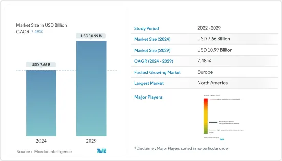
市場規模は2024年に76億6,000万米ドルと推定され、2029年には109億9,000万米ドルに達すると予測され、予測期間(2024-2029年)のCAGRは7.48%で成長します。
主なハイライト
- 海上ナビゲーションは、船舶の航海の計画、管理、指示を含み、シーマンシップ、専門知識、科学技術の統合に依存しています。
- 海上では、船舶は安全かつ効率的に目的地に到達するため、位置、速度、方位に関する正確なデータに依存しています。この正確さの必要性は、出港時や入港時に特に重要です。船長や航海士などの海事専門家は、海上で船舶を誘導するために船舶航行ソフトウェアを利用しています。このソフトウェアは、全地球航法衛星システム(GNSS)、電子航法図(ENC)、リアルタイムデータ、高度なアルゴリズムを統合しています。これらの技術が一体となって、正確な測位、航路計画、衝突回避など、効果的な海上航行に不可欠な機能を提供しています。
- マリンナビゲーションソフトウェアは、今日の船員にとって不可欠なものとなり、海上の安全性、効率性、環境への責任を高めています。このソフトウェアを活用することで、ユーザーはより正確な到着時間を計画し、より安全なルートを航行し、事故のリスクを減らし、効率を向上させ、排出ガスを削減し、継続的な燃料節約につなげることができます。
- クルージング、セーリング、レースなどのマリン・レクリエーションは人気が急上昇しています。これらのアクティビティにはそれぞれ独自の要件があり、安全性と使いやすさが最優先されます。航路計画、AIS機能、レーダー・オーバーレイ、魚群探知機などの機能は重要ではありますが、その重要度はさまざまです。その結果、ルートプランニング、セキュリティーコーン、オドメーターナビゲーションを含むレクリエーション用マリンナビゲーションソフトウェアの需要は増加傾向にあります。
- 今日、携帯電話にナビゲーションアプリを入れていない船員は珍しく、ヨットでは固定式のマルチファンクションディスプレイ(MFD)よりもタブレットが好まれるようになっています。手元にナビゲーション情報があるのは便利ですが、船員はモーターボート乗りと比べて優先する情報が異なります。気象情報の更新はありがたいものの、潮汐予報を理解することが最も重要です。船員が重視するのは、風向きやコースとの関連性、近くのランドマークなどの詳細です。レジャー用マリンナビゲーションソフトウェアは、これらすべてのサービスを1つのプラットフォームに統合しています。
レジャー用マリンナビゲーションソフトウェアの市場動向
レジャー用マリンナビゲーションにおけるIoT技術と位置情報近接の統合が市場の成長を促進
- 国連の国際海事機関(IMO)は、当初"e-navigation "と呼ばれていた海上IoTの概念を導入しました。このイニシアチブの中心的な目的は、海洋航行データの合理化とデジタル化であり、広範な海事サービスを強化することでした。他のIoTアプリケーションと同様、堅牢な通信、特にMTC(Machine Type Communication)は、このビジョンを実現する上で極めて重要な役割を果たします。
- レーダーやオートパイロットが進化を遂げる一方で、iOSボート・アプリケーションの多様化が進んでいます。今日、スマートフォンにナビゲーション・アプリを入れていない船員に出会うことはめったにありません。実際、ヨットの固定式マルチファンクションディスプレイ(MFD)よりもタブレットを選ぶ人が多く、ナビゲーション情報を外出先からすぐに入手できる利点を高く評価しています。多くの選択肢がある中で、いくつかのナビゲーションアプリが船員の間で人気となっています。
- 船員やヨットオーナーにとって、優先順位はモーターボート乗りとは異なります。天候を把握することが重要であることに変わりはありませんが、船員は潮の満ち引きのパターンや風の強弱、航行への影響、特にコースとの関連性を理解することに重きを置きます。さらに、近くの興味深いスポットに関する洞察を求め、レクリエーションのセーリング体験を強化します。
北米が最大の市場シェアを占める
- 米国沿岸警備隊およびボート安全協会の報告によると、2023 年には米国が約1,150万隻のレクリエーション ボートを登録し、世界の数を独占しました。カナダはレクリエーション・ボート分野で重要なプレーヤーとして浮上します。
- 伝統的に、国のレジャーボート数はGDPや人口と相関関係があります。経済規模や人口が大きいほどボートの数が多い傾向にありますが、例外もあります。たとえばカナダです。米国に比べて人口が少ないにもかかわらず、カナダは世界的に見ても特筆すべきレジャーボート数を誇っています。この異常さは主に、その広大な海岸線と複雑な運河網によるもので、堅牢なボート文化を育んでいます。
- 北米のレジャー用マリンナビゲーションソフトウェア市場の成長を後押ししている要因はいくつかあります。可処分所得の増加、都市化、高い技術導入率、アウトドア活動への関心の高まりなどです。人口が増加し、高度な海洋ナビゲーション技術を受け入れるように、レクリエーションのための海洋ナビゲーションソフトウェアの需要はさらに成長するように設定されています。
レジャー用マリンナビゲーションソフトウェア産業の概要
レジャー用マリンナビゲーションソフトウェア市場では、Timezero、i-Boating、Rose Point、Expedition Marineなどの主要企業が激しい競争を繰り広げています。彼らは最先端のソフトウェアを展開するために買収、発売、およびコラボレーションなどの戦略を活用しています。また、これらの企業は研究開発を優先し、常に技術の限界を押し広げ、市場の優位性を確固たるものにしています。
- 2024年4月、AI海事ソリューションの主要企業であるSeadronixは、最新のイノベーションであるRec-SEAプラグインを発表しました。この先進的なAIソフトウェアは、LiDARやRADARなどの船上センサーを活用することで、従来の船舶を「スマート」な船舶に変えます。Rec-SEAプラグインは安全性を高めるだけでなく、海事環境における業務効率も向上させます。
- 2024年3月、Kongsberg Discoveryは、慣性航法製品ラインの30周年を記念して、Seapath(R)385を発表しました。最先端のハードウェアと高度なナビゲーションアルゴリズムを組み合わせたこの最新システムは、水路測量において比類ない精度を保証します。Seapath 385は、慣性技術と処理アルゴリズムを、多周波GPS、GLONASS、Galileo、Beidou、QZSS、静止衛星を含む幅広い衛星信号と統合しています。Kongsberg DiscoveryのプレミアムMGC(R)(モーション・ジャイロ・コンパス)またはMRU(モーション・リファレンス・ユニット)慣性センサーからのデータをGNSSデータと共にシームレスに処理し、RTK、PPP、またはDGNSS補正を提供します。
その他の特典:
- エクセル形式の市場予測(ME)シート
- 3ヶ月のアナリストサポート
目次
第1章 イントロダクション
- 調査の成果
- 調査の前提
- 調査範囲
第2章 調査手法
第3章 エグゼクティブサマリー
第4章 市場力学
- 市場概要
- 市場促進要因
- IoT技術と位置近接の統合
- GIS、マッピング、モデリングツールの進歩
- クラウドベースの展開の増加
- 市場抑制要因
- インフラの初期費用が高い
- オープンソースソフトウェアの利用可能性
- 業界の魅力- ポーターのファイブフォース分析
- 新規参入業者の脅威
- 買い手/消費者の交渉力
- 供給企業の交渉力
- 代替品の脅威
- 競争企業間の敵対関係の強さ
- 主な使用事例とケーススタディ
- エコシステム分析
第5章 市場セグメンテーション
- 製品別
- ソフトウェア
- サービス
- 展開タイプ別
- クラウド
- オンプレミス
- プラットフォーム別
- ノートPC
- モバイル
- 地域別
- 北米
- 欧州
- アジア太平洋
- 世界のその他の地域
第6章 競合情勢
- 企業プロファイル
- Timezero
- i-Boating
- Rose Point
- EuroNav
- Expedition Marine
- NaAVIC
- Chetu
- BME-Barrenjoey Marine Electrics
- Danelec Marine A/S
- Periskal Group
第7章 投資分析
第8章 市場機会と今後の動向
目次
The Market size is estimated at USD 7.66 billion in 2024, and is expected to reach USD 10.99 billion by 2029, growing at a CAGR of 7.48% during the forecast period (2024-2029).
Key Highlights
- Marine navigation involves planning, managing, and directing a vessel's voyage, relying on seamanship, professional expertise, and the integration of science and technology.
- At sea, vessels depend on precise data regarding their position, speed, and heading to reach their destinations safely and efficiently. This need for accuracy is especially crucial during port departures and arrivals. Maritime professionals, such as ship captains and navigators, utilize marine navigation software to guide vessels at sea. This software integrates Global Navigation Satellite Systems (GNSS), electronic navigation charts (ENCs), real-time data, and advanced algorithms. Together, these technologies provide precise positioning, route planning, collision avoidance, and other essential features for effective maritime navigation.
- Marine navigation software has become indispensable for today's sailors, enhancing maritime safety, efficiency, and environmental responsibility. By leveraging this software, users can plan more precise arrival times, sail safer routes, reduce the risk of incidents, improve efficiency, and cut emissions, leading to continual fuel savings.
- Marine recreational activities, such as cruising, sailing, and racing, are experiencing a surge in popularity. Each of these activities has its own unique requirements, with safety and user-friendliness being top priorities. Features like route planning, AIS capabilities, radar overlays, and fish finders, while important, hold varying degrees of significance. Consequently, the demand for recreational marine navigation software, including route planning, security cones, and odometer navigation, is on the rise.
- Today, it's uncommon to find a sailor without a navigation app on their phone, with tablets increasingly preferred over fixed multifunction displays (MFDs) on yachts. While having navigation information at hand and on the go is convenient, sailors prioritize different information compared to motorboaters. While weather updates are appreciated, understanding the tide forecast is paramount. Sailors focus on details like wind direction, its relevance to their course, and nearby landmarks. Recreational marine navigation software consolidates all these services in one platform.
Recreational Marine Navigation Software Market Trends
Integration of IoT Technology and Location Proximity in Recreational Marine Navigation is Fueling the Market's Growth
- The International Maritime Organization (IMO) of the United Nations introduced the concept of maritime IoT, initially termed "e-navigation." This initiative's core objective was to streamline and digitize marine navigation data, enhancing a spectrum of maritime services. As with any IoT application, robust communication, particularly MTC (Machine Type Communication), plays a pivotal role in realizing this vision.
- While radar and autopilots have seen advancements, a diverse array of iOS boating applications is increasingly aiding boaters. Today, it's a rarity to encounter a sailor without a navigation app on their smartphone. In fact, many are opting for tablets over fixed multifunction displays (MFDs) on yachts, appreciating the advantage of having navigation information readily available on the go. Amidst the plethora of options, several navigation apps have emerged as favorites among sailors.
- For sailors and yacht owners, their priorities differ from those of motorboaters. While weather awareness remains crucial, sailors place a premium on comprehending tide patterns, wind dynamics, and their implications on navigation, especially in relation to their course. Additionally, they seek insights on nearby points of interest, enhancing their recreational sailing experiences.
North America to Hold Largest Market Share
- In 2023, the US, with around 11.5 million registered recreational boats, dominated the global count, as reported by the US Coastguard and Boating Safety Association. Canada emerges as a significant player in the recreational boating sector.
- Traditionally, a nation's recreational boat count correlates with its GDP and population. While larger economies and populations tend to have more boats, there are exceptions. Take Canada, for example. Despite a smaller population compared to the US, it boasts a notable recreational boat count on the world stage. This anomaly is largely due to its extensive coastline and intricate canal network, nurturing a robust boating culture.
- Several factors are driving the growth of North America's recreational marine navigation software market. These include rising disposable incomes, urbanization, a strong tech adoption rate, and a growing interest in outdoor activities. As the population swells and embraces advanced marine navigation technology, the demand for recreational marine navigation software is set for further growth.
Recreational Marine Navigation Software Industry Overview
In the Recreational Marine Navigation Software market, key players like Timezero, i-Boating, Rose Point, and Expedition Marine engage in fierce competition. They leverage strategies like acquisitions, launches, and collaborations to roll out cutting-edge software. These firms also prioritize R&D, constantly pushing the boundaries of technology to cement their market dominance.
- April 2024: Seadronix, a key player in AI maritime solutions, introduced its latest innovation: the Rec-SEA Plugin. This advanced AI software transforms traditional vessels into 'smart' ships by leveraging onboard sensors such as LiDAR and RADAR. The Rec-SEA Plugin not only enhances safety but also elevates operational efficiency in maritime environments.
- March 2024: Celebrating the 30th anniversary of its inertial navigation product line, Kongsberg Discovery unveiled the Seapath(R) 385. This state-of-the-art system combines cutting-edge hardware with advanced navigation algorithms, ensuring unmatched precision for hydrographic surveying. Seapath 385 integrates inertial technology and processing algorithms with a wide array of satellite signals, including multi-frequency GPS, GLONASS, Galileo, Beidou, QZSS, and geostationary. It seamlessly processes data from Kongsberg Discovery's premium MGC(R) (motion gyro compass) or MRU (motion reference unit) inertial sensors, alongside GNSS data, offering RTK, PPP, or DGNSS corrections.
Additional Benefits:
- The market estimate (ME) sheet in Excel format
- 3 months of analyst support
TABLE OF CONTENTS
1 INTRODUCTION
- 1.1 Study Deliverables
- 1.2 Study Assumptions
- 1.3 Scope of the Study
2 RESEARCH METHODOLOGY
3 EXECUTIVE SUMMARY
4 MARKET DYNAMICS
- 4.1 Market Overview
- 4.2 Market Drivers
- 4.2.1 Integration of IoT Technology and Location Proximity
- 4.2.2 Advancement in GIS, Mapping, and Modelling Tools
- 4.2.3 Rise in Cloud-based Deployment
- 4.3 Market Restraints
- 4.3.1 High Initial Expenses in Infrastructure
- 4.3.2 Availability of Open-source Software
- 4.4 Industry Attractiveness - Porter's Five Forces Analysis
- 4.4.1 Threat of New Entrants
- 4.4.2 Bargaining Power of Buyers/Consumers
- 4.4.3 Bargaining Power of Suppliers
- 4.4.4 Threat of Substitute Products
- 4.4.5 Intensity of Competitive Rivalry
- 4.5 Key Use Cases and Case Studies
- 4.6 Ecosystem Analysis
5 MARKET SEGMENTATION
- 5.1 By Offering
- 5.1.1 Software
- 5.1.2 Services
- 5.2 By Deployment Type
- 5.2.1 Cloud
- 5.2.2 On-premise
- 5.3 By Platform
- 5.3.1 Laptop/PCs
- 5.3.2 Mobile
- 5.4 By Geography
- 5.4.1 North America
- 5.4.2 Europe
- 5.4.3 Asia-Pacific
- 5.4.4 Rest of World
6 COMPETITIVE LANDSCAPE
- 6.1 Company Profiles
- 6.1.1 Timezero
- 6.1.2 i-Boating
- 6.1.3 Rose Point
- 6.1.4 EuroNav
- 6.1.5 Expedition Marine
- 6.1.6 NaAVIC
- 6.1.7 Chetu
- 6.1.8 BME - Barrenjoey Marine Electrics
- 6.1.9 Danelec Marine A/S
- 6.1.10 Periskal Group
7 INVESTMENT ANALYSIS
8 MARKET OPPORTUNITIES AND FUTURE TRENDS
- 発行日
- 発行
- Mordor Intelligence
- ページ情報
- 英文 183 Pages
- 納期
- 2~3営業日