|
|
市場調査レポート
商品コード
1154851
GNSSシミュレーターの世界市場規模、シェア、産業動向分析レポートレシーバー別(GPS、Galileo、GLONASS、BeiDou、その他)、アプリケーション別、コンポーネント別、業種別、地域別展望・予測、2022年~2028年Global GNSS Simulators Market Size, Share & Industry Trends Analysis Report By Receiver (GPS, Galileo, GLONASS, BeiDou, and Others), By Application, By Component, By Vertical, By Regional Outlook and Forecast, 2022 - 2028 |
||||||
|
|
|||||||


| GNSSシミュレーターの世界市場規模、シェア、産業動向分析レポートレシーバー別(GPS、Galileo、GLONASS、BeiDou、その他)、アプリケーション別、コンポーネント別、業種別、地域別展望・予測、2022年~2028年 |
|
出版日: 2022年10月31日
発行: KBV Research
ページ情報: 英文 374 Pages
納期: 即納可能
|
- 全表示
- 概要
- 図表
- 目次
GNSSシミュレーターの世界市場規模は、2028年には3億1080万米ドルに達し、予測期間中にCAGR9.2%で上昇すると予測されています。
受信機が位置を特定するためには、少なくとも3つの衛星からデータを取得する必要があります。GNSS衛星は、11時間58分2秒に一度、中軌道の高さで地球を周回します。各衛星は、正確な軌道情報と原子時計の高精度なタイムスタンプを符号化した信号を配信しています。衛星から送信される時刻情報は、受信機が信号の送信時刻を継続的に特定できるようにコード化されています。
この信号は、受信機が衛星の位置を計算し、正確に配置するために利用する情報から構成されています。受信した信号の時刻と放送時刻の時間差から、受信機は衛星との距離や範囲を計算します。受信機は、各衛星に対する正確な位置がわかると、その位置を地球ベースの座標に変換し、その結果を緯度、経度、高度として提供します。
COVID-19の影響分析
COVID-19は製造業を麻痺させた。当初は新興国を中心に発生していたが、時間の経過とともに世界各国に影響が及び始め、いくつかの国ではロックダウンが実施されました。スロバキアの企業Sygic社をはじめとする技術系企業の有志が、COVID-19ウイルスの拡散を制限するモバイルアプリケーションを開発しました。GNSSとBluetoothのセンサーを使い、ユーザーが過去14日以内に感染者と接触したかどうかを判断する仕組みです。今後数年間、GNSSシミュレーターはまともな成長を見せると思われます。
市場の成長要因
コンシューマー向けIoTデバイスの急速な普及
コンシューマー向けIoTとは、コンシューマー向けガジェットやデバイスがネットワーク化された環境を指します。GNSSシミュレーターの市場の主要な技術促進要因です。GNSSは、モノのインターネットとリンクした都市環境の大部分を支える中核技術の1つです。GNSSは、リアルタイムの追跡、タイミング、ナビゲーション、その他のマシン間通信を可能にし、IoTデバイス管理の基盤として機能します。IoTにおけるGNSSの関連性は、デバイスが自分の位置と近くにある他のユニットの位置を決定する能力と、そのデータを意味のある情報にまとめる能力によって要約されます。
ドローンの需要拡大
米国、英国、オーストラリアなどの国では、商業用UAVの運用に許可やライセンスを発行しています。UAVにはGNSSチップが搭載され、追跡、記録、リアルタイムデータの送信を行うことができます。連邦航空局(FAA)は、法執行機関が25ポンド以下のUAVを400フィート以下で使用することを許可しています。同機関は訓練のためにUAVを使用することができますが、運用許可を得る前にその熟練度を実証する必要があります。企業は、継続的に居場所を追跡するために、様々な用途に適応したGNSS一体型のUAVを作成しています。
市場抑制要因
GNSSシミュレーターのデジタルインフラ不足
GNSSを利用しない重要なデジタルインフラを見つけることは困難です。インターネットアクセスやICTインフラのような最新のデジタルインフラがないことは、デジタル、ロケーションベースのビジネスモデルやサービスの採用を妨げる大きな障害となっています。低所得の新興国は、デジタルインフラの未発達、消費者や労働者の限られたデジタル能力、不十分な財政支援、弱い規制環境、消費者、企業、政府のデジタル取引に対する信頼度の低さなど、いくつかの持続的な課題に直面しています。
タイプ別展望
GNSSシミュレーター市場は、タイプ別にシングルチャネルとマルチチャネルに分類されます。マルチチャンネルセグメントは、2021年にGNSSシミュレーター市場で最も高い収益シェアを獲得しました。RFシミュレータの第二形態は、多くのチャネルを含み、頻繁にコンスタレーションシミュレータと呼ばれています。これは、所定の運用環境における複数の衛星信号のコヒーレント・モデリングを提供します。この種の機器は、研究開発だけでなく、ほぼすべての設計、生産、販売後のテストに広く利用されています。
レシーバーの展望
GNSSシミュレーター市場は、レシーバーごとにGPS、Galileo、GLONASS、BeiDou、その他のレシーバーに分類されます。2021年のGNSSシミュレーター市場では、Beidouセグメントがかなりの収益シェアを示しています。BeiDouは、静止アジア太平洋ローカルネットワークであるBeidou-1として始まりましたが、その後、非稼働となりました。中国では、2011年12月に第2バージョンのBeiDou-2が運用を開始しました。BeiDou-3は、30機のMEO衛星と5機の静止衛星(IGSO)で構成されることが想定されています。
アプリケーションの展望
GNSSシミュレーター市場は、アプリケーションによって、ナビゲーション&マッピング、測量、ロケーションベースサービス、車両アシストシステム、その他のアプリケーションに二分されます。2021年のGNSSシミュレーター市場では、車両アシストシステム部門が大きな収益シェアを記録しました。Spirentソフトウェアの開発は、センサーフュージョンのための現実的な位置、ナビゲーション、タイミングテストに対する自動車業界の需要の増加が動機となっています。テストラボは、先進運転支援システム(ADAS)機能やインフォテインメントシステムの強化につながるWi-Fi、カメラ、ライダー、レーダー、慣性、GNSSデータを混合できる必要があり、顧客が自動車メーカーにこれらの機能の実装を求める圧力が高まっているためです。
コンポーネントの展望
GNSSシミュレーター市場は、コンポーネントによってハードウェア、ソフトウェア、サービスに区分されます。2021年のGNSSシミュレーター市場では、ハードウェア部門が最も高い収益シェアを獲得しています。HILシミュレータは、オペレータが操作する自動車やフライトシミュレータである場合があり、速度、加速度、ジャークなどの運動パラメータに加えて位置データを生成し、オプションでヨー、ピッチ、ロール角の形で姿勢データも生成することができます。この情報は、SCPIリモートコントロール命令によってSMBVに送信されます。GNSS受信機は最新のGNSS信号を受信し、位置を計算します。
サービスの展望
サービスタイプ別では、GNSSシミュレーター市場はプロフェッショナルサービスとマネージドサービスに細分化されます。プロフェッショナルサービス分野は、2021年のGNSSシミュレーター市場において最大の収益シェアを調達しました。専門的なサービスは、顧客の成果への成功の旅に不可欠であることを定義しているため、いくつかの合理的な質問を探索することが重要です。特に、サービスの収束と、以前は別々だった部門の曖昧化が急速に進行している場合です。顧客は、企業や法人からプロフェッショナルサービスを受けることもできます。
業界別展望
GNSSシミュレーター市場は、業界別では、軍事・防衛、自動車、家電、海洋、航空宇宙、その他に分類されます。軍事・防衛分野は、2021年のGNSSシミュレーター市場において最大の収益シェアを獲得しました。これは、軍事環境では、GNSSシステムが通信システムの時刻を提供するために頻繁に採用されており、これにより、安全な音声およびデータ伝送を提供するための効率的でコスト効率の良いネットワーク同期が可能になるからです。
地域別の展望
地域別に見ると、GNSSシミュレーター市場は、北米、欧州、アジア太平洋、LAMEAで分析されています。アジア太平洋地域は、2021年にGNSSシミュレーター市場で有望な成長率を獲得しました。この地域の新興経済諸国は、GNSS技術を提供し、改善するために他の地域と連携しています。これは、技術の改善と適応が容易であり、組織がエンドユーザーに優れたソリューションを提供することができるので、アジア太平洋のGNSSシミュレーターの市場に利益をもたらしています。
市場参入企業がとる主な戦略は、パートナーシップです。カーディナルマトリックスで提示された分析によると、Keysight Technologies, Inc.とHexagon ABがGNSSシミュレーター市場の先駆者です。U-blox Holding AG、Spirent Communications plc、Rohde &Schwarz GmbH &Co.KGなどの企業がGNSSシミュレーター市場の主要な革新的企業です。KGなどの企業がGNSSシミュレーター市場の主要なイノベーターとして挙げられます。
目次
第1章 市場の範囲と調査手法
- 市場の定義
- 目的
- 市場規模
- セグメンテーション
- GNSSシミュレーターの世界市場、タイプ別
- GNSSシミュレーターの世界市場、レシーバー別
- GNSSシミュレーターの世界市場、アプリケーション別
- GNSSシミュレーターの世界市場、コンポーネント別
- GNSSシミュレーターの世界市場、業界別
- GNSSシミュレーターの世界市場、地域別
- 調査手法
第2章 市場概要
- イントロダクション
- 概要
- 市場の構成とシナリオ
- 概要
- 市場に影響を与える主要因
- 市場促進要因
- 市場の抑制要因
第3章 競合分析-世界
- KBVカーディナルマトリックス
- 最近の業界全体の戦略的展開
- パートナーシップ、コラボレーション、契約
- 製品上市と製品拡張
- 買収と合併
- 地理的拡大
- 主要成功戦略
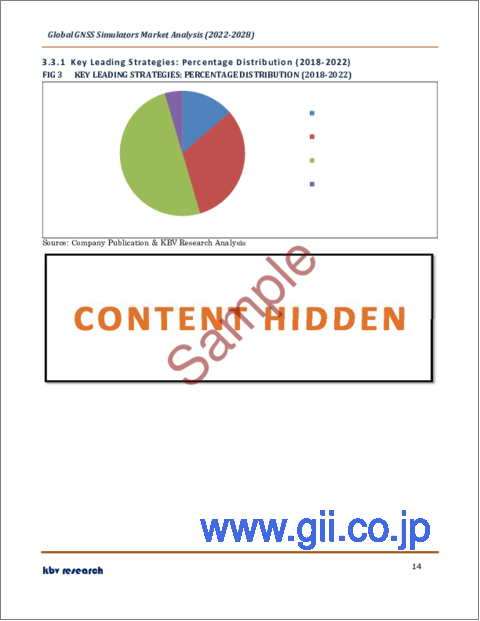
- 主要なリーディング戦略:割合の分布(2018-2022)
- 主要な戦略的動き:(パートナーシップ、コラボレーション&アグリーメント:2020年、1月~2022年、10月)主要なプレーヤーたち
第4章 GNSSシミュレーターの世界市場:タイプ別
- マルチチャンネルの世界市場:地域別
- 世界のシングルチャンネル市場:地域別
第5章 GNSSシミュレーターの世界市場:レシーバー別
- GPSの世界市場:地域別
- ガリレオの世界市場:地域別
- 世界のGLONASSの地域別市場
- BeiDouの世界市場:地域別
- 地域別世界のその他市場
第6章 GNSSシミュレーターの世界市場:アプリケーション別
- 世界のナビゲーション&マッピング市場:地域別
- 測量の世界市場:地域別
- 位置情報サービスの世界市場:地域別
- 車両支援システムの世界市場:地域別
- その他の地域別世界市場
第7章 GNSSシミュレーターの世界市場:コンポーネント別
- ハードウェアの世界市場:地域別
- ソフトウェアの世界市場:地域別
- サービスの世界市場:地域別
- GNSSシミュレーターの世界市場:サービスタイプ別
- プロフェッショナルサービスの世界市場:地域別
- マネージドサービスの世界市場:地域別
第8章 GNSSシミュレーターの世界市場:業界別
- 軍事・防衛の世界市場:地域別
- 民生用電子機器の世界市場:地域別
- 自動車用世界市場:地域別
- 海洋の世界市場:地域別
- 航空宇宙の世界市場:地域別
- 地域別世界のその他市場
第9章 GNSSシミュレーターの世界市場:地域別
- 北米
- 北米のGNSSシミュレーター市場:国別
- 米国
- カナダ
- メキシコ
- その他北米地域
- 北米のGNSSシミュレーター市場:国別
- 欧州
- 欧州のGNSSシミュレーター市場:国別
- ドイツ
- 英国
- フランス
- ロシア
- スペイン
- イタリア
- その他欧州
- 欧州のGNSSシミュレーター市場:国別
- アジア太平洋地域
- アジア太平洋地域のGNSSシミュレーター市場:国別
- 中国
- 日本
- インド
- 韓国
- シンガポール
- マレーシア
- その他アジア太平洋地域
- アジア太平洋地域のGNSSシミュレーター市場:国別
- LAMEA
- LAMEAのGNSSシミュレーター市場:国別
- ブラジル
- アルゼンチン
- UAE
- サウジアラビア
- 南アフリカ共和国
- ナイジェリア
- LAMEAの他の地域
- LAMEAのGNSSシミュレーター市場:国別
第10章 企業プロファイル
- Spirent Communications plc
- Keysight Technologies, Inc.
- Viavi Solutions, Inc.
- Hexagon AB
- U-blox Holding AG
- Rohde & Schwarz GmbH & Co. KG
- Syntony GNSS
- RACELOGIC Ltd.
- Averna Technologies, Inc.
- Accord Software & Systems Private Limited
LIST OF TABLES
- TABLE 1 Global GNSS Simulators Market, 2018 - 2021, USD Thousands
- TABLE 2 Global GNSS Simulators Market, 2022 - 2028, USD Thousands
- TABLE 3 Partnerships, Collaborations and Agreements- GNSS Simulators Market
- TABLE 4 Product Launches And Product Expansions- GNSS Simulators Market
- TABLE 5 Acquisition and Mergers- GNSS Simulators Market
- TABLE 6 Geographical Expansions - GNSS Simulators Market
- TABLE 7 Global GNSS Simulators Market by Type, 2018 - 2021, USD Thousands
- TABLE 8 Global GNSS Simulators Market by Type, 2022 - 2028, USD Thousands
- TABLE 9 Global Multi Channnel Market by Region, 2018 - 2021, USD Thousands
- TABLE 10 Global Multi Channnel Market by Region, 2022 - 2028, USD Thousands
- TABLE 11 Global Single Channnel Market by Region, 2018 - 2021, USD Thousands
- TABLE 12 Global Single Channnel Market by Region, 2022 - 2028, USD Thousands
- TABLE 13 Global GNSS Simulators Market by Receiver, 2018 - 2021, USD Thousands
- TABLE 14 Global GNSS Simulators Market by Receiver, 2022 - 2028, USD Thousands
- TABLE 15 Global GPS Market by Region, 2018 - 2021, USD Thousands
- TABLE 16 Global GPS Market by Region, 2022 - 2028, USD Thousands
- TABLE 17 Global Galileo Market by Region, 2018 - 2021, USD Thousands
- TABLE 18 Global Galileo Market by Region, 2022 - 2028, USD Thousands
- TABLE 19 Global GLONASS Market by Region, 2018 - 2021, USD Thousands
- TABLE 20 Global GLONASS Market by Region, 2022 - 2028, USD Thousands
- TABLE 21 Global BeiDou Market by Region, 2018 - 2021, USD Thousands
- TABLE 22 Global BeiDou Market by Region, 2022 - 2028, USD Thousands
- TABLE 23 Global Others Market by Region, 2018 - 2021, USD Thousands
- TABLE 24 Global Others Market by Region, 2022 - 2028, USD Thousands
- TABLE 25 Global GNSS Simulators Market by Application, 2018 - 2021, USD Thousands
- TABLE 26 Global GNSS Simulators Market by Application, 2022 - 2028, USD Thousands
- TABLE 27 Global Navigation & Mapping Market by Region, 2018 - 2021, USD Thousands
- TABLE 28 Global Navigation & Mapping Market by Region, 2022 - 2028, USD Thousands
- TABLE 29 Global Surveying Market by Region, 2018 - 2021, USD Thousands
- TABLE 30 Global Surveying Market by Region, 2022 - 2028, USD Thousands
- TABLE 31 Global Location-based Services Market by Region, 2018 - 2021, USD Thousands
- TABLE 32 Global Location-based Services Market by Region, 2022 - 2028, USD Thousands
- TABLE 33 Global Vehicle Assistance System Market by Region, 2018 - 2021, USD Thousands
- TABLE 34 Global Vehicle Assistance System Market by Region, 2022 - 2028, USD Thousands
- TABLE 35 Global Others Market by Region, 2018 - 2021, USD Thousands
- TABLE 36 Global Others Market by Region, 2022 - 2028, USD Thousands
- TABLE 37 Global GNSS Simulators Market by Component, 2018 - 2021, USD Thousands
- TABLE 38 Global GNSS Simulators Market by Component, 2022 - 2028, USD Thousands
- TABLE 39 Global Hardware Market by Region, 2018 - 2021, USD Thousands
- TABLE 40 Global Hardware Market by Region, 2022 - 2028, USD Thousands
- TABLE 41 Global Software Market by Region, 2018 - 2021, USD Thousands
- TABLE 42 Global Software Market by Region, 2022 - 2028, USD Thousands
- TABLE 43 Global Services Market by Region, 2018 - 2021, USD Thousands
- TABLE 44 Global Services Market by Region, 2022 - 2028, USD Thousands
- TABLE 45 Global GNSS Simulators Market by Services Type, 2018 - 2021, USD Thousands
- TABLE 46 Global GNSS Simulators Market by Services Type, 2022 - 2028, USD Thousands
- TABLE 47 Global Professional Services Market by Region, 2018 - 2021, USD Thousands
- TABLE 48 Global Professional Services Market by Region, 2022 - 2028, USD Thousands
- TABLE 49 Global Managed Services Market by Region, 2018 - 2021, USD Thousands
- TABLE 50 Global Managed Services Market by Region, 2022 - 2028, USD Thousands
- TABLE 51 Global GNSS Simulators Market by Vertical, 2018 - 2021, USD Thousands
- TABLE 52 Global GNSS Simulators Market by Vertical, 2022 - 2028, USD Thousands
- TABLE 53 Global Military & Defense Market by Region, 2018 - 2021, USD Thousands
- TABLE 54 Global Military & Defense Market by Region, 2022 - 2028, USD Thousands
- TABLE 55 Global Consumer Electronics Market by Region, 2018 - 2021, USD Thousands
- TABLE 56 Global Consumer Electronics Market by Region, 2022 - 2028, USD Thousands
- TABLE 57 Global Automotive Market by Region, 2018 - 2021, USD Thousands
- TABLE 58 Global Automotive Market by Region, 2022 - 2028, USD Thousands
- TABLE 59 Global Marine Market by Region, 2018 - 2021, USD Thousands
- TABLE 60 Global Marine Market by Region, 2022 - 2028, USD Thousands
- TABLE 61 Global Aerospace Market by Region, 2018 - 2021, USD Thousands
- TABLE 62 Global Aerospace Market by Region, 2022 - 2028, USD Thousands
- TABLE 63 Global Others Market by Region, 2018 - 2021, USD Thousands
- TABLE 64 Global Others Market by Region, 2022 - 2028, USD Thousands
- TABLE 65 Global GNSS Simulators Market by Region, 2018 - 2021, USD Thousands
- TABLE 66 Global GNSS Simulators Market by Region, 2022 - 2028, USD Thousands
- TABLE 67 North America GNSS Simulators Market, 2018 - 2021, USD Thousands
- TABLE 68 North America GNSS Simulators Market, 2022 - 2028, USD Thousands
- TABLE 69 North America GNSS Simulators Market by Type, 2018 - 2021, USD Thousands
- TABLE 70 North America GNSS Simulators Market by Type, 2022 - 2028, USD Thousands
- TABLE 71 North America Multi Channnel Market by Country, 2018 - 2021, USD Thousands
- TABLE 72 North America Multi Channnel Market by Country, 2022 - 2028, USD Thousands
- TABLE 73 North America Single Channnel Market by Country, 2018 - 2021, USD Thousands
- TABLE 74 North America Single Channnel Market by Country, 2022 - 2028, USD Thousands
- TABLE 75 North America GNSS Simulators Market by Receiver, 2018 - 2021, USD Thousands
- TABLE 76 North America GNSS Simulators Market by Receiver, 2022 - 2028, USD Thousands
- TABLE 77 North America GPS Market by Country, 2018 - 2021, USD Thousands
- TABLE 78 North America GPS Market by Country, 2022 - 2028, USD Thousands
- TABLE 79 North America Galileo Market by Country, 2018 - 2021, USD Thousands
- TABLE 80 North America Galileo Market by Country, 2022 - 2028, USD Thousands
- TABLE 81 North America GLONASS Market by Country, 2018 - 2021, USD Thousands
- TABLE 82 North America GLONASS Market by Country, 2022 - 2028, USD Thousands
- TABLE 83 North America BeiDou Market by Country, 2018 - 2021, USD Thousands
- TABLE 84 North America BeiDou Market by Country, 2022 - 2028, USD Thousands
- TABLE 85 North America Others Market by Country, 2018 - 2021, USD Thousands
- TABLE 86 North America Others Market by Country, 2022 - 2028, USD Thousands
- TABLE 87 North America GNSS Simulators Market by Application, 2018 - 2021, USD Thousands
- TABLE 88 North America GNSS Simulators Market by Application, 2022 - 2028, USD Thousands
- TABLE 89 North America Navigation & Mapping Market by Country, 2018 - 2021, USD Thousands
- TABLE 90 North America Navigation & Mapping Market by Country, 2022 - 2028, USD Thousands
- TABLE 91 North America Surveying Market by Country, 2018 - 2021, USD Thousands
- TABLE 92 North America Surveying Market by Country, 2022 - 2028, USD Thousands
- TABLE 93 North America Location-based Services Market by Country, 2018 - 2021, USD Thousands
- TABLE 94 North America Location-based Services Market by Country, 2022 - 2028, USD Thousands
- TABLE 95 North America Vehicle Assistance System Market by Country, 2018 - 2021, USD Thousands
- TABLE 96 North America Vehicle Assistance System Market by Country, 2022 - 2028, USD Thousands
- TABLE 97 North America Others Market by Country, 2018 - 2021, USD Thousands
- TABLE 98 North America Others Market by Country, 2022 - 2028, USD Thousands
- TABLE 99 North America GNSS Simulators Market by Component, 2018 - 2021, USD Thousands
- TABLE 100 North America GNSS Simulators Market by Component, 2022 - 2028, USD Thousands
- TABLE 101 North America Hardware Market by Country, 2018 - 2021, USD Thousands
- TABLE 102 North America Hardware Market by Country, 2022 - 2028, USD Thousands
- TABLE 103 North America Software Market by Country, 2018 - 2021, USD Thousands
- TABLE 104 North America Software Market by Country, 2022 - 2028, USD Thousands
- TABLE 105 North America Services Market by Country, 2018 - 2021, USD Thousands
- TABLE 106 North America Services Market by Country, 2022 - 2028, USD Thousands
- TABLE 107 North America GNSS Simulators Market by Services Type, 2018 - 2021, USD Thousands
- TABLE 108 North America GNSS Simulators Market by Services Type, 2022 - 2028, USD Thousands
- TABLE 109 North America Professional Services Market by Country, 2018 - 2021, USD Thousands
- TABLE 110 North America Professional Services Market by Country, 2022 - 2028, USD Thousands
- TABLE 111 North America Managed Services Market by Country, 2018 - 2021, USD Thousands
- TABLE 112 North America Managed Services Market by Country, 2022 - 2028, USD Thousands
- TABLE 113 North America GNSS Simulators Market by Vertical, 2018 - 2021, USD Thousands
- TABLE 114 North America GNSS Simulators Market by Vertical, 2022 - 2028, USD Thousands
- TABLE 115 North America Military & Defense Market by Country, 2018 - 2021, USD Thousands
- TABLE 116 North America Military & Defense Market by Country, 2022 - 2028, USD Thousands
- TABLE 117 North America Consumer Electronics Market by Country, 2018 - 2021, USD Thousands
- TABLE 118 North America Consumer Electronics Market by Country, 2022 - 2028, USD Thousands
- TABLE 119 North America Automotive Market by Country, 2018 - 2021, USD Thousands
- TABLE 120 North America Automotive Market by Country, 2022 - 2028, USD Thousands
- TABLE 121 North America Marine Market by Country, 2018 - 2021, USD Thousands
- TABLE 122 North America Marine Market by Country, 2022 - 2028, USD Thousands
- TABLE 123 North America Aerospace Market by Country, 2018 - 2021, USD Thousands
- TABLE 124 North America Aerospace Market by Country, 2022 - 2028, USD Thousands
- TABLE 125 North America Others Market by Country, 2018 - 2021, USD Thousands
- TABLE 126 North America Others Market by Country, 2022 - 2028, USD Thousands
- TABLE 127 North America GNSS Simulators Market by Country, 2018 - 2021, USD Thousands
- TABLE 128 North America GNSS Simulators Market by Country, 2022 - 2028, USD Thousands
- TABLE 129 US GNSS Simulators Market, 2018 - 2021, USD Thousands
- TABLE 130 US GNSS Simulators Market, 2022 - 2028, USD Thousands
- TABLE 131 US GNSS Simulators Market by Type, 2018 - 2021, USD Thousands
- TABLE 132 US GNSS Simulators Market by Type, 2022 - 2028, USD Thousands
- TABLE 133 US GNSS Simulators Market by Receiver, 2018 - 2021, USD Thousands
- TABLE 134 US GNSS Simulators Market by Receiver, 2022 - 2028, USD Thousands
- TABLE 135 US GNSS Simulators Market by Application, 2018 - 2021, USD Thousands
- TABLE 136 US GNSS Simulators Market by Application, 2022 - 2028, USD Thousands
- TABLE 137 US GNSS Simulators Market by Component, 2018 - 2021, USD Thousands
- TABLE 138 US GNSS Simulators Market by Component, 2022 - 2028, USD Thousands
- TABLE 139 US GNSS Simulators Market by Services Type, 2018 - 2021, USD Thousands
- TABLE 140 US GNSS Simulators Market by Services Type, 2022 - 2028, USD Thousands
- TABLE 141 US GNSS Simulators Market by Vertical, 2018 - 2021, USD Thousands
- TABLE 142 US GNSS Simulators Market by Vertical, 2022 - 2028, USD Thousands
- TABLE 143 Canada GNSS Simulators Market, 2018 - 2021, USD Thousands
- TABLE 144 Canada GNSS Simulators Market, 2022 - 2028, USD Thousands
- TABLE 145 Canada GNSS Simulators Market by Type, 2018 - 2021, USD Thousands
- TABLE 146 Canada GNSS Simulators Market by Type, 2022 - 2028, USD Thousands
- TABLE 147 Canada GNSS Simulators Market by Receiver, 2018 - 2021, USD Thousands
- TABLE 148 Canada GNSS Simulators Market by Receiver, 2022 - 2028, USD Thousands
- TABLE 149 Canada GNSS Simulators Market by Application, 2018 - 2021, USD Thousands
- TABLE 150 Canada GNSS Simulators Market by Application, 2022 - 2028, USD Thousands
- TABLE 151 Canada GNSS Simulators Market by Component, 2018 - 2021, USD Thousands
- TABLE 152 Canada GNSS Simulators Market by Component, 2022 - 2028, USD Thousands
- TABLE 153 Canada GNSS Simulators Market by Services Type, 2018 - 2021, USD Thousands
- TABLE 154 Canada GNSS Simulators Market by Services Type, 2022 - 2028, USD Thousands
- TABLE 155 Canada GNSS Simulators Market by Vertical, 2018 - 2021, USD Thousands
- TABLE 156 Canada GNSS Simulators Market by Vertical, 2022 - 2028, USD Thousands
- TABLE 157 Mexico GNSS Simulators Market, 2018 - 2021, USD Thousands
- TABLE 158 Mexico GNSS Simulators Market, 2022 - 2028, USD Thousands
- TABLE 159 Mexico GNSS Simulators Market by Type, 2018 - 2021, USD Thousands
- TABLE 160 Mexico GNSS Simulators Market by Type, 2022 - 2028, USD Thousands
- TABLE 161 Mexico GNSS Simulators Market by Receiver, 2018 - 2021, USD Thousands
- TABLE 162 Mexico GNSS Simulators Market by Receiver, 2022 - 2028, USD Thousands
- TABLE 163 Mexico GNSS Simulators Market by Application, 2018 - 2021, USD Thousands
- TABLE 164 Mexico GNSS Simulators Market by Application, 2022 - 2028, USD Thousands
- TABLE 165 Mexico GNSS Simulators Market by Component, 2018 - 2021, USD Thousands
- TABLE 166 Mexico GNSS Simulators Market by Component, 2022 - 2028, USD Thousands
- TABLE 167 Mexico GNSS Simulators Market by Services Type, 2018 - 2021, USD Thousands
- TABLE 168 Mexico GNSS Simulators Market by Services Type, 2022 - 2028, USD Thousands
- TABLE 169 Mexico GNSS Simulators Market by Vertical, 2018 - 2021, USD Thousands
- TABLE 170 Mexico GNSS Simulators Market by Vertical, 2022 - 2028, USD Thousands
- TABLE 171 Rest of North America GNSS Simulators Market, 2018 - 2021, USD Thousands
- TABLE 172 Rest of North America GNSS Simulators Market, 2022 - 2028, USD Thousands
- TABLE 173 Rest of North America GNSS Simulators Market by Type, 2018 - 2021, USD Thousands
- TABLE 174 Rest of North America GNSS Simulators Market by Type, 2022 - 2028, USD Thousands
- TABLE 175 Rest of North America GNSS Simulators Market by Receiver, 2018 - 2021, USD Thousands
- TABLE 176 Rest of North America GNSS Simulators Market by Receiver, 2022 - 2028, USD Thousands
- TABLE 177 Rest of North America GNSS Simulators Market by Application, 2018 - 2021, USD Thousands
- TABLE 178 Rest of North America GNSS Simulators Market by Application, 2022 - 2028, USD Thousands
- TABLE 179 Rest of North America GNSS Simulators Market by Component, 2018 - 2021, USD Thousands
- TABLE 180 Rest of North America GNSS Simulators Market by Component, 2022 - 2028, USD Thousands
- TABLE 181 Rest of North America GNSS Simulators Market by Services Type, 2018 - 2021, USD Thousands
- TABLE 182 Rest of North America GNSS Simulators Market by Services Type, 2022 - 2028, USD Thousands
- TABLE 183 Rest of North America GNSS Simulators Market by Vertical, 2018 - 2021, USD Thousands
- TABLE 184 Rest of North America GNSS Simulators Market by Vertical, 2022 - 2028, USD Thousands
- TABLE 185 Europe GNSS Simulators Market, 2018 - 2021, USD Thousands
- TABLE 186 Europe GNSS Simulators Market, 2022 - 2028, USD Thousands
- TABLE 187 Europe GNSS Simulators Market by Type, 2018 - 2021, USD Thousands
- TABLE 188 Europe GNSS Simulators Market by Type, 2022 - 2028, USD Thousands
- TABLE 189 Europe Multi Channnel Market by Country, 2018 - 2021, USD Thousands
- TABLE 190 Europe Multi Channnel Market by Country, 2022 - 2028, USD Thousands
- TABLE 191 Europe Single Channnel Market by Country, 2018 - 2021, USD Thousands
- TABLE 192 Europe Single Channnel Market by Country, 2022 - 2028, USD Thousands
- TABLE 193 Europe GNSS Simulators Market by Receiver, 2018 - 2021, USD Thousands
- TABLE 194 Europe GNSS Simulators Market by Receiver, 2022 - 2028, USD Thousands
- TABLE 195 Europe GPS Market by Country, 2018 - 2021, USD Thousands
- TABLE 196 Europe GPS Market by Country, 2022 - 2028, USD Thousands
- TABLE 197 Europe Galileo Market by Country, 2018 - 2021, USD Thousands
- TABLE 198 Europe Galileo Market by Country, 2022 - 2028, USD Thousands
- TABLE 199 Europe GLONASS Market by Country, 2018 - 2021, USD Thousands
- TABLE 200 Europe GLONASS Market by Country, 2022 - 2028, USD Thousands
- TABLE 201 Europe BeiDou Market by Country, 2018 - 2021, USD Thousands
- TABLE 202 Europe BeiDou Market by Country, 2022 - 2028, USD Thousands
- TABLE 203 Europe Others Market by Country, 2018 - 2021, USD Thousands
- TABLE 204 Europe Others Market by Country, 2022 - 2028, USD Thousands
- TABLE 205 Europe GNSS Simulators Market by Application, 2018 - 2021, USD Thousands
- TABLE 206 Europe GNSS Simulators Market by Application, 2022 - 2028, USD Thousands
- TABLE 207 Europe Navigation & Mapping Market by Country, 2018 - 2021, USD Thousands
- TABLE 208 Europe Navigation & Mapping Market by Country, 2022 - 2028, USD Thousands
- TABLE 209 Europe Surveying Market by Country, 2018 - 2021, USD Thousands
- TABLE 210 Europe Surveying Market by Country, 2022 - 2028, USD Thousands
- TABLE 211 Europe Location-based Services Market by Country, 2018 - 2021, USD Thousands
- TABLE 212 Europe Location-based Services Market by Country, 2022 - 2028, USD Thousands
- TABLE 213 Europe Vehicle Assistance System Market by Country, 2018 - 2021, USD Thousands
- TABLE 214 Europe Vehicle Assistance System Market by Country, 2022 - 2028, USD Thousands
- TABLE 215 Europe Others Market by Country, 2018 - 2021, USD Thousands
- TABLE 216 Europe Others Market by Country, 2022 - 2028, USD Thousands
- TABLE 217 Europe GNSS Simulators Market by Component, 2018 - 2021, USD Thousands
- TABLE 218 Europe GNSS Simulators Market by Component, 2022 - 2028, USD Thousands
- TABLE 219 Europe Hardware Market by Country, 2018 - 2021, USD Thousands
- TABLE 220 Europe Hardware Market by Country, 2022 - 2028, USD Thousands
- TABLE 221 Europe Software Market by Country, 2018 - 2021, USD Thousands
- TABLE 222 Europe Software Market by Country, 2022 - 2028, USD Thousands
- TABLE 223 Europe Services Market by Country, 2018 - 2021, USD Thousands
- TABLE 224 Europe Services Market by Country, 2022 - 2028, USD Thousands
- TABLE 225 Europe GNSS Simulators Market by Services Type, 2018 - 2021, USD Thousands
- TABLE 226 Europe GNSS Simulators Market by Services Type, 2022 - 2028, USD Thousands
- TABLE 227 Europe Professional Services Market by Country, 2018 - 2021, USD Thousands
- TABLE 228 Europe Professional Services Market by Country, 2022 - 2028, USD Thousands
- TABLE 229 Europe Managed Services Market by Country, 2018 - 2021, USD Thousands
- TABLE 230 Europe Managed Services Market by Country, 2022 - 2028, USD Thousands
- TABLE 231 Europe GNSS Simulators Market by Vertical, 2018 - 2021, USD Thousands
- TABLE 232 Europe GNSS Simulators Market by Vertical, 2022 - 2028, USD Thousands
- TABLE 233 Europe Military & Defense Market by Country, 2018 - 2021, USD Thousands
- TABLE 234 Europe Military & Defense Market by Country, 2022 - 2028, USD Thousands
- TABLE 235 Europe Consumer Electronics Market by Country, 2018 - 2021, USD Thousands
- TABLE 236 Europe Consumer Electronics Market by Country, 2022 - 2028, USD Thousands
- TABLE 237 Europe Automotive Market by Country, 2018 - 2021, USD Thousands
- TABLE 238 Europe Automotive Market by Country, 2022 - 2028, USD Thousands
- TABLE 239 Europe Marine Market by Country, 2018 - 2021, USD Thousands
- TABLE 240 Europe Marine Market by Country, 2022 - 2028, USD Thousands
- TABLE 241 Europe Aerospace Market by Country, 2018 - 2021, USD Thousands
- TABLE 242 Europe Aerospace Market by Country, 2022 - 2028, USD Thousands
- TABLE 243 Europe Others Market by Country, 2018 - 2021, USD Thousands
- TABLE 244 Europe Others Market by Country, 2022 - 2028, USD Thousands
- TABLE 245 Europe GNSS Simulators Market by Country, 2018 - 2021, USD Thousands
- TABLE 246 Europe GNSS Simulators Market by Country, 2022 - 2028, USD Thousands
- TABLE 247 Germany GNSS Simulators Market, 2018 - 2021, USD Thousands
- TABLE 248 Germany GNSS Simulators Market, 2022 - 2028, USD Thousands
- TABLE 249 Germany GNSS Simulators Market by Type, 2018 - 2021, USD Thousands
- TABLE 250 Germany GNSS Simulators Market by Type, 2022 - 2028, USD Thousands
- TABLE 251 Germany GNSS Simulators Market by Receiver, 2018 - 2021, USD Thousands
- TABLE 252 Germany GNSS Simulators Market by Receiver, 2022 - 2028, USD Thousands
- TABLE 253 Germany GNSS Simulators Market by Application, 2018 - 2021, USD Thousands
- TABLE 254 Germany GNSS Simulators Market by Application, 2022 - 2028, USD Thousands
- TABLE 255 Germany GNSS Simulators Market by Component, 2018 - 2021, USD Thousands
- TABLE 256 Germany GNSS Simulators Market by Component, 2022 - 2028, USD Thousands
- TABLE 257 Germany GNSS Simulators Market by Services Type, 2018 - 2021, USD Thousands
- TABLE 258 Germany GNSS Simulators Market by Services Type, 2022 - 2028, USD Thousands
- TABLE 259 Germany GNSS Simulators Market by Vertical, 2018 - 2021, USD Thousands
- TABLE 260 Germany GNSS Simulators Market by Vertical, 2022 - 2028, USD Thousands
- TABLE 261 UK GNSS Simulators Market, 2018 - 2021, USD Thousands
- TABLE 262 UK GNSS Simulators Market, 2022 - 2028, USD Thousands
- TABLE 263 UK GNSS Simulators Market by Type, 2018 - 2021, USD Thousands
- TABLE 264 UK GNSS Simulators Market by Type, 2022 - 2028, USD Thousands
- TABLE 265 UK GNSS Simulators Market by Receiver, 2018 - 2021, USD Thousands
- TABLE 266 UK GNSS Simulators Market by Receiver, 2022 - 2028, USD Thousands
- TABLE 267 UK GNSS Simulators Market by Application, 2018 - 2021, USD Thousands
- TABLE 268 UK GNSS Simulators Market by Application, 2022 - 2028, USD Thousands
- TABLE 269 UK GNSS Simulators Market by Component, 2018 - 2021, USD Thousands
- TABLE 270 UK GNSS Simulators Market by Component, 2022 - 2028, USD Thousands
- TABLE 271 UK GNSS Simulators Market by Services Type, 2018 - 2021, USD Thousands
- TABLE 272 UK GNSS Simulators Market by Services Type, 2022 - 2028, USD Thousands
- TABLE 273 UK GNSS Simulators Market by Vertical, 2018 - 2021, USD Thousands
- TABLE 274 UK GNSS Simulators Market by Vertical, 2022 - 2028, USD Thousands
- TABLE 275 France GNSS Simulators Market, 2018 - 2021, USD Thousands
- TABLE 276 France GNSS Simulators Market, 2022 - 2028, USD Thousands
- TABLE 277 France GNSS Simulators Market by Type, 2018 - 2021, USD Thousands
- TABLE 278 France GNSS Simulators Market by Type, 2022 - 2028, USD Thousands
- TABLE 279 France GNSS Simulators Market by Receiver, 2018 - 2021, USD Thousands
- TABLE 280 France GNSS Simulators Market by Receiver, 2022 - 2028, USD Thousands
- TABLE 281 France GNSS Simulators Market by Application, 2018 - 2021, USD Thousands
- TABLE 282 France GNSS Simulators Market by Application, 2022 - 2028, USD Thousands
- TABLE 283 France GNSS Simulators Market by Component, 2018 - 2021, USD Thousands
- TABLE 284 France GNSS Simulators Market by Component, 2022 - 2028, USD Thousands
- TABLE 285 France GNSS Simulators Market by Services Type, 2018 - 2021, USD Thousands
- TABLE 286 France GNSS Simulators Market by Services Type, 2022 - 2028, USD Thousands
- TABLE 287 France GNSS Simulators Market by Vertical, 2018 - 2021, USD Thousands
- TABLE 288 France GNSS Simulators Market by Vertical, 2022 - 2028, USD Thousands
- TABLE 289 Russia GNSS Simulators Market, 2018 - 2021, USD Thousands
- TABLE 290 Russia GNSS Simulators Market, 2022 - 2028, USD Thousands
- TABLE 291 Russia GNSS Simulators Market by Type, 2018 - 2021, USD Thousands
- TABLE 292 Russia GNSS Simulators Market by Type, 2022 - 2028, USD Thousands
- TABLE 293 Russia GNSS Simulators Market by Receiver, 2018 - 2021, USD Thousands
- TABLE 294 Russia GNSS Simulators Market by Receiver, 2022 - 2028, USD Thousands
- TABLE 295 Russia GNSS Simulators Market by Application, 2018 - 2021, USD Thousands
- TABLE 296 Russia GNSS Simulators Market by Application, 2022 - 2028, USD Thousands
- TABLE 297 Russia GNSS Simulators Market by Component, 2018 - 2021, USD Thousands
- TABLE 298 Russia GNSS Simulators Market by Component, 2022 - 2028, USD Thousands
- TABLE 299 Russia GNSS Simulators Market by Services Type, 2018 - 2021, USD Thousands
- TABLE 300 Russia GNSS Simulators Market by Services Type, 2022 - 2028, USD Thousands
- TABLE 301 Russia GNSS Simulators Market by Vertical, 2018 - 2021, USD Thousands
- TABLE 302 Russia GNSS Simulators Market by Vertical, 2022 - 2028, USD Thousands
- TABLE 303 Spain GNSS Simulators Market, 2018 - 2021, USD Thousands
- TABLE 304 Spain GNSS Simulators Market, 2022 - 2028, USD Thousands
- TABLE 305 Spain GNSS Simulators Market by Type, 2018 - 2021, USD Thousands
- TABLE 306 Spain GNSS Simulators Market by Type, 2022 - 2028, USD Thousands
- TABLE 307 Spain GNSS Simulators Market by Receiver, 2018 - 2021, USD Thousands
- TABLE 308 Spain GNSS Simulators Market by Receiver, 2022 - 2028, USD Thousands
- TABLE 309 Spain GNSS Simulators Market by Application, 2018 - 2021, USD Thousands
- TABLE 310 Spain GNSS Simulators Market by Application, 2022 - 2028, USD Thousands
- TABLE 311 Spain GNSS Simulators Market by Component, 2018 - 2021, USD Thousands
- TABLE 312 Spain GNSS Simulators Market by Component, 2022 - 2028, USD Thousands
- TABLE 313 Spain GNSS Simulators Market by Services Type, 2018 - 2021, USD Thousands
- TABLE 314 Spain GNSS Simulators Market by Services Type, 2022 - 2028, USD Thousands
- TABLE 315 Spain GNSS Simulators Market by Vertical, 2018 - 2021, USD Thousands
- TABLE 316 Spain GNSS Simulators Market by Vertical, 2022 - 2028, USD Thousands
- TABLE 317 Italy GNSS Simulators Market, 2018 - 2021, USD Thousands
- TABLE 318 Italy GNSS Simulators Market, 2022 - 2028, USD Thousands
- TABLE 319 Italy GNSS Simulators Market by Type, 2018 - 2021, USD Thousands
- TABLE 320 Italy GNSS Simulators Market by Type, 2022 - 2028, USD Thousands
- TABLE 321 Italy GNSS Simulators Market by Receiver, 2018 - 2021, USD Thousands
- TABLE 322 Italy GNSS Simulators Market by Receiver, 2022 - 2028, USD Thousands
- TABLE 323 Italy GNSS Simulators Market by Application, 2018 - 2021, USD Thousands
- TABLE 324 Italy GNSS Simulators Market by Application, 2022 - 2028, USD Thousands
- TABLE 325 Italy GNSS Simulators Market by Component, 2018 - 2021, USD Thousands
- TABLE 326 Italy GNSS Simulators Market by Component, 2022 - 2028, USD Thousands
- TABLE 327 Italy GNSS Simulators Market by Services Type, 2018 - 2021, USD Thousands
- TABLE 328 Italy GNSS Simulators Market by Services Type, 2022 - 2028, USD Thousands
- TABLE 329 Italy GNSS Simulators Market by Vertical, 2018 - 2021, USD Thousands
- TABLE 330 Italy GNSS Simulators Market by Vertical, 2022 - 2028, USD Thousands
- TABLE 331 Rest of Europe GNSS Simulators Market, 2018 - 2021, USD Thousands
- TABLE 332 Rest of Europe GNSS Simulators Market, 2022 - 2028, USD Thousands
- TABLE 333 Rest of Europe GNSS Simulators Market by Type, 2018 - 2021, USD Thousands
- TABLE 334 Rest of Europe GNSS Simulators Market by Type, 2022 - 2028, USD Thousands
- TABLE 335 Rest of Europe GNSS Simulators Market by Receiver, 2018 - 2021, USD Thousands
- TABLE 336 Rest of Europe GNSS Simulators Market by Receiver, 2022 - 2028, USD Thousands
- TABLE 337 Rest of Europe GNSS Simulators Market by Application, 2018 - 2021, USD Thousands
- TABLE 338 Rest of Europe GNSS Simulators Market by Application, 2022 - 2028, USD Thousands
- TABLE 339 Rest of Europe GNSS Simulators Market by Component, 2018 - 2021, USD Thousands
- TABLE 340 Rest of Europe GNSS Simulators Market by Component, 2022 - 2028, USD Thousands
- TABLE 341 Rest of Europe GNSS Simulators Market by Services Type, 2018 - 2021, USD Thousands
- TABLE 342 Rest of Europe GNSS Simulators Market by Services Type, 2022 - 2028, USD Thousands
- TABLE 343 Rest of Europe GNSS Simulators Market by Vertical, 2018 - 2021, USD Thousands
- TABLE 344 Rest of Europe GNSS Simulators Market by Vertical, 2022 - 2028, USD Thousands
- TABLE 345 Asia Pacific GNSS Simulators Market, 2018 - 2021, USD Thousands
- TABLE 346 Asia Pacific GNSS Simulators Market, 2022 - 2028, USD Thousands
- TABLE 347 Asia Pacific GNSS Simulators Market by Type, 2018 - 2021, USD Thousands
- TABLE 348 Asia Pacific GNSS Simulators Market by Type, 2022 - 2028, USD Thousands
- TABLE 349 Asia Pacific Multi Channnel Market by Country, 2018 - 2021, USD Thousands
- TABLE 350 Asia Pacific Multi Channnel Market by Country, 2022 - 2028, USD Thousands
- TABLE 351 Asia Pacific Single Channnel Market by Country, 2018 - 2021, USD Thousands
- TABLE 352 Asia Pacific Single Channnel Market by Country, 2022 - 2028, USD Thousands
- TABLE 353 Asia Pacific GNSS Simulators Market by Receiver, 2018 - 2021, USD Thousands
- TABLE 354 Asia Pacific GNSS Simulators Market by Receiver, 2022 - 2028, USD Thousands
- TABLE 355 Asia Pacific GPS Market by Country, 2018 - 2021, USD Thousands
- TABLE 356 Asia Pacific GPS Market by Country, 2022 - 2028, USD Thousands
- TABLE 357 Asia Pacific Galileo Market by Country, 2018 - 2021, USD Thousands
- TABLE 358 Asia Pacific Galileo Market by Country, 2022 - 2028, USD Thousands
- TABLE 359 Asia Pacific GLONASS Market by Country, 2018 - 2021, USD Thousands
- TABLE 360 Asia Pacific GLONASS Market by Country, 2022 - 2028, USD Thousands
- TABLE 361 Asia Pacific BeiDou Market by Country, 2018 - 2021, USD Thousands
- TABLE 362 Asia Pacific BeiDou Market by Country, 2022 - 2028, USD Thousands
- TABLE 363 Asia Pacific Others Market by Country, 2018 - 2021, USD Thousands
- TABLE 364 Asia Pacific Others Market by Country, 2022 - 2028, USD Thousands
- TABLE 365 Asia Pacific GNSS Simulators Market by Application, 2018 - 2021, USD Thousands
- TABLE 366 Asia Pacific GNSS Simulators Market by Application, 2022 - 2028, USD Thousands
- TABLE 367 Asia Pacific Navigation & Mapping Market by Country, 2018 - 2021, USD Thousands
- TABLE 368 Asia Pacific Navigation & Mapping Market by Country, 2022 - 2028, USD Thousands
- TABLE 369 Asia Pacific Surveying Market by Country, 2018 - 2021, USD Thousands
- TABLE 370 Asia Pacific Surveying Market by Country, 2022 - 2028, USD Thousands
- TABLE 371 Asia Pacific Location-based Services Market by Country, 2018 - 2021, USD Thousands
- TABLE 372 Asia Pacific Location-based Services Market by Country, 2022 - 2028, USD Thousands
- TABLE 373 Asia Pacific Vehicle Assistance System Market by Country, 2018 - 2021, USD Thousands
- TABLE 374 Asia Pacific Vehicle Assistance System Market by Country, 2022 - 2028, USD Thousands
- TABLE 375 Asia Pacific Others Market by Country, 2018 - 2021, USD Thousands
- TABLE 376 Asia Pacific Others Market by Country, 2022 - 2028, USD Thousands
- TABLE 377 Asia Pacific GNSS Simulators Market by Component, 2018 - 2021, USD Thousands
- TABLE 378 Asia Pacific GNSS Simulators Market by Component, 2022 - 2028, USD Thousands
- TABLE 379 Asia Pacific Hardware Market by Country, 2018 - 2021, USD Thousands
- TABLE 380 Asia Pacific Hardware Market by Country, 2022 - 2028, USD Thousands
- TABLE 381 Asia Pacific Software Market by Country, 2018 - 2021, USD Thousands
- TABLE 382 Asia Pacific Software Market by Country, 2022 - 2028, USD Thousands
- TABLE 383 Asia Pacific Services Market by Country, 2018 - 2021, USD Thousands
- TABLE 384 Asia Pacific Services Market by Country, 2022 - 2028, USD Thousands
- TABLE 385 Asia Pacific GNSS Simulators Market by Services Type, 2018 - 2021, USD Thousands
- TABLE 386 Asia Pacific GNSS Simulators Market by Services Type, 2022 - 2028, USD Thousands
- TABLE 387 Asia Pacific Professional Services Market by Country, 2018 - 2021, USD Thousands
- TABLE 388 Asia Pacific Professional Services Market by Country, 2022 - 2028, USD Thousands
- TABLE 389 Asia Pacific Managed Services Market by Country, 2018 - 2021, USD Thousands
- TABLE 390 Asia Pacific Managed Services Market by Country, 2022 - 2028, USD Thousands
- TABLE 391 Asia Pacific GNSS Simulators Market by Vertical, 2018 - 2021, USD Thousands
- TABLE 392 Asia Pacific GNSS Simulators Market by Vertical, 2022 - 2028, USD Thousands
- TABLE 393 Asia Pacific Military & Defense Market by Country, 2018 - 2021, USD Thousands
- TABLE 394 Asia Pacific Military & Defense Market by Country, 2022 - 2028, USD Thousands
- TABLE 395 Asia Pacific Consumer Electronics Market by Country, 2018 - 2021, USD Thousands
- TABLE 396 Asia Pacific Consumer Electronics Market by Country, 2022 - 2028, USD Thousands
- TABLE 397 Asia Pacific Automotive Market by Country, 2018 - 2021, USD Thousands
- TABLE 398 Asia Pacific Automotive Market by Country, 2022 - 2028, USD Thousands
- TABLE 399 Asia Pacific Marine Market by Country, 2018 - 2021, USD Thousands
- TABLE 400 Asia Pacific Marine Market by Country, 2022 - 2028, USD Thousands
- TABLE 401 Asia Pacific Aerospace Market by Country, 2018 - 2021, USD Thousands
- TABLE 402 Asia Pacific Aerospace Market by Country, 2022 - 2028, USD Thousands
- TABLE 403 Asia Pacific Others Market by Country, 2018 - 2021, USD Thousands
- TABLE 404 Asia Pacific Others Market by Country, 2022 - 2028, USD Thousands
- TABLE 405 Asia Pacific GNSS Simulators Market by Country, 2018 - 2021, USD Thousands
- TABLE 406 Asia Pacific GNSS Simulators Market by Country, 2022 - 2028, USD Thousands
- TABLE 407 China GNSS Simulators Market, 2018 - 2021, USD Thousands
- TABLE 408 China GNSS Simulators Market, 2022 - 2028, USD Thousands
- TABLE 409 China GNSS Simulators Market by Type, 2018 - 2021, USD Thousands
- TABLE 410 China GNSS Simulators Market by Type, 2022 - 2028, USD Thousands
- TABLE 411 China GNSS Simulators Market by Receiver, 2018 - 2021, USD Thousands
- TABLE 412 China GNSS Simulators Market by Receiver, 2022 - 2028, USD Thousands
- TABLE 413 China GNSS Simulators Market by Application, 2018 - 2021, USD Thousands
- TABLE 414 China GNSS Simulators Market by Application, 2022 - 2028, USD Thousands
- TABLE 415 China GNSS Simulators Market by Component, 2018 - 2021, USD Thousands
- TABLE 416 China GNSS Simulators Market by Component, 2022 - 2028, USD Thousands
- TABLE 417 China GNSS Simulators Market by Services Type, 2018 - 2021, USD Thousands
- TABLE 418 China GNSS Simulators Market by Services Type, 2022 - 2028, USD Thousands
- TABLE 419 China GNSS Simulators Market by Vertical, 2018 - 2021, USD Thousands
- TABLE 420 China GNSS Simulators Market by Vertical, 2022 - 2028, USD Thousands
- TABLE 421 Japan GNSS Simulators Market, 2018 - 2021, USD Thousands
- TABLE 422 Japan GNSS Simulators Market, 2022 - 2028, USD Thousands
- TABLE 423 Japan GNSS Simulators Market by Type, 2018 - 2021, USD Thousands
- TABLE 424 Japan GNSS Simulators Market by Type, 2022 - 2028, USD Thousands
- TABLE 425 Japan GNSS Simulators Market by Receiver, 2018 - 2021, USD Thousands
- TABLE 426 Japan GNSS Simulators Market by Receiver, 2022 - 2028, USD Thousands
- TABLE 427 Japan GNSS Simulators Market by Application, 2018 - 2021, USD Thousands
- TABLE 428 Japan GNSS Simulators Market by Application, 2022 - 2028, USD Thousands
- TABLE 429 Japan GNSS Simulators Market by Component, 2018 - 2021, USD Thousands
- TABLE 430 Japan GNSS Simulators Market by Component, 2022 - 2028, USD Thousands
- TABLE 431 Japan GNSS Simulators Market by Services Type, 2018 - 2021, USD Thousands
- TABLE 432 Japan GNSS Simulators Market by Services Type, 2022 - 2028, USD Thousands
- TABLE 433 Japan GNSS Simulators Market by Vertical, 2018 - 2021, USD Thousands
- TABLE 434 Japan GNSS Simulators Market by Vertical, 2022 - 2028, USD Thousands
- TABLE 435 India GNSS Simulators Market, 2018 - 2021, USD Thousands
- TABLE 436 India GNSS Simulators Market, 2022 - 2028, USD Thousands
- TABLE 437 India GNSS Simulators Market by Type, 2018 - 2021, USD Thousands
- TABLE 438 India GNSS Simulators Market by Type, 2022 - 2028, USD Thousands
- TABLE 439 India GNSS Simulators Market by Receiver, 2018 - 2021, USD Thousands
- TABLE 440 India GNSS Simulators Market by Receiver, 2022 - 2028, USD Thousands
- TABLE 441 India GNSS Simulators Market by Application, 2018 - 2021, USD Thousands
- TABLE 442 India GNSS Simulators Market by Application, 2022 - 2028, USD Thousands
- TABLE 443 India GNSS Simulators Market by Component, 2018 - 2021, USD Thousands
- TABLE 444 India GNSS Simulators Market by Component, 2022 - 2028, USD Thousands
- TABLE 445 India GNSS Simulators Market by Services Type, 2018 - 2021, USD Thousands
- TABLE 446 India GNSS Simulators Market by Services Type, 2022 - 2028, USD Thousands
- TABLE 447 India GNSS Simulators Market by Vertical, 2018 - 2021, USD Thousands
- TABLE 448 India GNSS Simulators Market by Vertical, 2022 - 2028, USD Thousands
- TABLE 449 South Korea GNSS Simulators Market, 2018 - 2021, USD Thousands
- TABLE 450 South Korea GNSS Simulators Market, 2022 - 2028, USD Thousands
- TABLE 451 South Korea GNSS Simulators Market by Type, 2018 - 2021, USD Thousands
- TABLE 452 South Korea GNSS Simulators Market by Type, 2022 - 2028, USD Thousands
- TABLE 453 South Korea GNSS Simulators Market by Receiver, 2018 - 2021, USD Thousands
- TABLE 454 South Korea GNSS Simulators Market by Receiver, 2022 - 2028, USD Thousands
- TABLE 455 South Korea GNSS Simulators Market by Application, 2018 - 2021, USD Thousands
- TABLE 456 South Korea GNSS Simulators Market by Application, 2022 - 2028, USD Thousands
- TABLE 457 South Korea GNSS Simulators Market by Component, 2018 - 2021, USD Thousands
- TABLE 458 South Korea GNSS Simulators Market by Component, 2022 - 2028, USD Thousands
- TABLE 459 South Korea GNSS Simulators Market by Services Type, 2018 - 2021, USD Thousands
- TABLE 460 South Korea GNSS Simulators Market by Services Type, 2022 - 2028, USD Thousands
- TABLE 461 South Korea GNSS Simulators Market by Vertical, 2018 - 2021, USD Thousands
- TABLE 462 South Korea GNSS Simulators Market by Vertical, 2022 - 2028, USD Thousands
- TABLE 463 Singapore GNSS Simulators Market, 2018 - 2021, USD Thousands
- TABLE 464 Singapore GNSS Simulators Market, 2022 - 2028, USD Thousands
- TABLE 465 Singapore GNSS Simulators Market by Type, 2018 - 2021, USD Thousands
- TABLE 466 Singapore GNSS Simulators Market by Type, 2022 - 2028, USD Thousands
- TABLE 467 Singapore GNSS Simulators Market by Receiver, 2018 - 2021, USD Thousands
- TABLE 468 Singapore GNSS Simulators Market by Receiver, 2022 - 2028, USD Thousands
- TABLE 469 Singapore GNSS Simulators Market by Application, 2018 - 2021, USD Thousands
- TABLE 470 Singapore GNSS Simulators Market by Application, 2022 - 2028, USD Thousands
- TABLE 471 Singapore GNSS Simulators Market by Component, 2018 - 2021, USD Thousands
- TABLE 472 Singapore GNSS Simulators Market by Component, 2022 - 2028, USD Thousands
- TABLE 473 Singapore GNSS Simulators Market by Services Type, 2018 - 2021, USD Thousands
- TABLE 474 Singapore GNSS Simulators Market by Services Type, 2022 - 2028, USD Thousands
- TABLE 475 Singapore GNSS Simulators Market by Vertical, 2018 - 2021, USD Thousands
- TABLE 476 Singapore GNSS Simulators Market by Vertical, 2022 - 2028, USD Thousands
- TABLE 477 Malaysia GNSS Simulators Market, 2018 - 2021, USD Thousands
- TABLE 478 Malaysia GNSS Simulators Market, 2022 - 2028, USD Thousands
- TABLE 479 Malaysia GNSS Simulators Market by Type, 2018 - 2021, USD Thousands
- TABLE 480 Malaysia GNSS Simulators Market by Type, 2022 - 2028, USD Thousands
- TABLE 481 Malaysia GNSS Simulators Market by Receiver, 2018 - 2021, USD Thousands
- TABLE 482 Malaysia GNSS Simulators Market by Receiver, 2022 - 2028, USD Thousands
- TABLE 483 Malaysia GNSS Simulators Market by Application, 2018 - 2021, USD Thousands
- TABLE 484 Malaysia GNSS Simulators Market by Application, 2022 - 2028, USD Thousands
- TABLE 485 Malaysia GNSS Simulators Market by Component, 2018 - 2021, USD Thousands
- TABLE 486 Malaysia GNSS Simulators Market by Component, 2022 - 2028, USD Thousands
- TABLE 487 Malaysia GNSS Simulators Market by Services Type, 2018 - 2021, USD Thousands
- TABLE 488 Malaysia GNSS Simulators Market by Services Type, 2022 - 2028, USD Thousands
- TABLE 489 Malaysia GNSS Simulators Market by Vertical, 2018 - 2021, USD Thousands
- TABLE 490 Malaysia GNSS Simulators Market by Vertical, 2022 - 2028, USD Thousands
- TABLE 491 Rest of Asia Pacific GNSS Simulators Market, 2018 - 2021, USD Thousands
- TABLE 492 Rest of Asia Pacific GNSS Simulators Market, 2022 - 2028, USD Thousands
- TABLE 493 Rest of Asia Pacific GNSS Simulators Market by Type, 2018 - 2021, USD Thousands
- TABLE 494 Rest of Asia Pacific GNSS Simulators Market by Type, 2022 - 2028, USD Thousands
- TABLE 495 Rest of Asia Pacific GNSS Simulators Market by Receiver, 2018 - 2021, USD Thousands
- TABLE 496 Rest of Asia Pacific GNSS Simulators Market by Receiver, 2022 - 2028, USD Thousands
- TABLE 497 Rest of Asia Pacific GNSS Simulators Market by Application, 2018 - 2021, USD Thousands
- TABLE 498 Rest of Asia Pacific GNSS Simulators Market by Application, 2022 - 2028, USD Thousands
- TABLE 499 Rest of Asia Pacific GNSS Simulators Market by Component, 2018 - 2021, USD Thousands
- TABLE 500 Rest of Asia Pacific GNSS Simulators Market by Component, 2022 - 2028, USD Thousands
- TABLE 501 Rest of Asia Pacific GNSS Simulators Market by Services Type, 2018 - 2021, USD Thousands
- TABLE 502 Rest of Asia Pacific GNSS Simulators Market by Services Type, 2022 - 2028, USD Thousands
- TABLE 503 Rest of Asia Pacific GNSS Simulators Market by Vertical, 2018 - 2021, USD Thousands
- TABLE 504 Rest of Asia Pacific GNSS Simulators Market by Vertical, 2022 - 2028, USD Thousands
- TABLE 505 LAMEA GNSS Simulators Market, 2018 - 2021, USD Thousands
- TABLE 506 LAMEA GNSS Simulators Market, 2022 - 2028, USD Thousands
- TABLE 507 LAMEA GNSS Simulators Market by Type, 2018 - 2021, USD Thousands
- TABLE 508 LAMEA GNSS Simulators Market by Type, 2022 - 2028, USD Thousands
- TABLE 509 LAMEA Multi Channnel Market by Country, 2018 - 2021, USD Thousands
- TABLE 510 LAMEA Multi Channnel Market by Country, 2022 - 2028, USD Thousands
- TABLE 511 LAMEA Single Channnel Market by Country, 2018 - 2021, USD Thousands
- TABLE 512 LAMEA Single Channnel Market by Country, 2022 - 2028, USD Thousands
- TABLE 513 LAMEA GNSS Simulators Market by Receiver, 2018 - 2021, USD Thousands
- TABLE 514 LAMEA GNSS Simulators Market by Receiver, 2022 - 2028, USD Thousands
- TABLE 515 LAMEA GPS Market by Country, 2018 - 2021, USD Thousands
- TABLE 516 LAMEA GPS Market by Country, 2022 - 2028, USD Thousands
- TABLE 517 LAMEA Galileo Market by Country, 2018 - 2021, USD Thousands
- TABLE 518 LAMEA Galileo Market by Country, 2022 - 2028, USD Thousands
- TABLE 519 LAMEA GLONASS Market by Country, 2018 - 2021, USD Thousands
- TABLE 520 LAMEA GLONASS Market by Country, 2022 - 2028, USD Thousands
- TABLE 521 LAMEA BeiDou Market by Country, 2018 - 2021, USD Thousands
- TABLE 522 LAMEA BeiDou Market by Country, 2022 - 2028, USD Thousands
- TABLE 523 LAMEA Others Market by Country, 2018 - 2021, USD Thousands
- TABLE 524 LAMEA Others Market by Country, 2022 - 2028, USD Thousands
- TABLE 525 LAMEA GNSS Simulators Market by Application, 2018 - 2021, USD Thousands
- TABLE 526 LAMEA GNSS Simulators Market by Application, 2022 - 2028, USD Thousands
- TABLE 527 LAMEA Navigation & Mapping Market by Country, 2018 - 2021, USD Thousands
- TABLE 528 LAMEA Navigation & Mapping Market by Country, 2022 - 2028, USD Thousands
- TABLE 529 LAMEA Surveying Market by Country, 2018 - 2021, USD Thousands
- TABLE 530 LAMEA Surveying Market by Country, 2022 - 2028, USD Thousands
- TABLE 531 LAMEA Location-based Services Market by Country, 2018 - 2021, USD Thousands
- TABLE 532 LAMEA Location-based Services Market by Country, 2022 - 2028, USD Thousands
- TABLE 533 LAMEA Vehicle Assistance System Market by Country, 2018 - 2021, USD Thousands
- TABLE 534 LAMEA Vehicle Assistance System Market by Country, 2022 - 2028, USD Thousands
- TABLE 535 LAMEA Others Market by Country, 2018 - 2021, USD Thousands
- TABLE 536 LAMEA Others Market by Country, 2022 - 2028, USD Thousands
- TABLE 537 LAMEA GNSS Simulators Market by Component, 2018 - 2021, USD Thousands
- TABLE 538 LAMEA GNSS Simulators Market by Component, 2022 - 2028, USD Thousands
- TABLE 539 LAMEA Hardware Market by Country, 2018 - 2021, USD Thousands
- TABLE 540 LAMEA Hardware Market by Country, 2022 - 2028, USD Thousands
- TABLE 541 LAMEA Software Market by Country, 2018 - 2021, USD Thousands
- TABLE 542 LAMEA Software Market by Country, 2022 - 2028, USD Thousands
- TABLE 543 LAMEA Services Market by Country, 2018 - 2021, USD Thousands
- TABLE 544 LAMEA Services Market by Country, 2022 - 2028, USD Thousands
- TABLE 545 LAMEA GNSS Simulators Market by Services Type, 2018 - 2021, USD Thousands
- TABLE 546 LAMEA GNSS Simulators Market by Services Type, 2022 - 2028, USD Thousands
- TABLE 547 LAMEA Professional Services Market by Country, 2018 - 2021, USD Thousands
- TABLE 548 LAMEA Professional Services Market by Country, 2022 - 2028, USD Thousands
- TABLE 549 LAMEA Managed Services Market by Country, 2018 - 2021, USD Thousands
- TABLE 550 LAMEA Managed Services Market by Country, 2022 - 2028, USD Thousands
- TABLE 551 LAMEA GNSS Simulators Market by Vertical, 2018 - 2021, USD Thousands
- TABLE 552 LAMEA GNSS Simulators Market by Vertical, 2022 - 2028, USD Thousands
- TABLE 553 LAMEA Military & Defense Market by Country, 2018 - 2021, USD Thousands
- TABLE 554 LAMEA Military & Defense Market by Country, 2022 - 2028, USD Thousands
- TABLE 555 LAMEA Consumer Electronics Market by Country, 2018 - 2021, USD Thousands
- TABLE 556 LAMEA Consumer Electronics Market by Country, 2022 - 2028, USD Thousands
- TABLE 557 LAMEA Automotive Market by Country, 2018 - 2021, USD Thousands
- TABLE 558 LAMEA Automotive Market by Country, 2022 - 2028, USD Thousands
- TABLE 559 LAMEA Marine Market by Country, 2018 - 2021, USD Thousands
- TABLE 560 LAMEA Marine Market by Country, 2022 - 2028, USD Thousands
- TABLE 561 LAMEA Aerospace Market by Country, 2018 - 2021, USD Thousands
- TABLE 562 LAMEA Aerospace Market by Country, 2022 - 2028, USD Thousands
- TABLE 563 LAMEA Others Market by Country, 2018 - 2021, USD Thousands
- TABLE 564 LAMEA Others Market by Country, 2022 - 2028, USD Thousands
- TABLE 565 LAMEA GNSS Simulators Market by Country, 2018 - 2021, USD Thousands
- TABLE 566 LAMEA GNSS Simulators Market by Country, 2022 - 2028, USD Thousands
- TABLE 567 Brazil GNSS Simulators Market, 2018 - 2021, USD Thousands
- TABLE 568 Brazil GNSS Simulators Market, 2022 - 2028, USD Thousands
- TABLE 569 Brazil GNSS Simulators Market by Type, 2018 - 2021, USD Thousands
- TABLE 570 Brazil GNSS Simulators Market by Type, 2022 - 2028, USD Thousands
- TABLE 571 Brazil GNSS Simulators Market by Receiver, 2018 - 2021, USD Thousands
- TABLE 572 Brazil GNSS Simulators Market by Receiver, 2022 - 2028, USD Thousands
- TABLE 573 Brazil GNSS Simulators Market by Application, 2018 - 2021, USD Thousands
- TABLE 574 Brazil GNSS Simulators Market by Application, 2022 - 2028, USD Thousands
- TABLE 575 Brazil GNSS Simulators Market by Component, 2018 - 2021, USD Thousands
- TABLE 576 Brazil GNSS Simulators Market by Component, 2022 - 2028, USD Thousands
- TABLE 577 Brazil GNSS Simulators Market by Services Type, 2018 - 2021, USD Thousands
- TABLE 578 Brazil GNSS Simulators Market by Services Type, 2022 - 2028, USD Thousands
- TABLE 579 Brazil GNSS Simulators Market by Vertical, 2018 - 2021, USD Thousands
- TABLE 580 Brazil GNSS Simulators Market by Vertical, 2022 - 2028, USD Thousands
- TABLE 581 Argentina GNSS Simulators Market, 2018 - 2021, USD Thousands
- TABLE 582 Argentina GNSS Simulators Market, 2022 - 2028, USD Thousands
- TABLE 583 Argentina GNSS Simulators Market by Type, 2018 - 2021, USD Thousands
- TABLE 584 Argentina GNSS Simulators Market by Type, 2022 - 2028, USD Thousands
- TABLE 585 Argentina GNSS Simulators Market by Receiver, 2018 - 2021, USD Thousands
- TABLE 586 Argentina GNSS Simulators Market by Receiver, 2022 - 2028, USD Thousands
- TABLE 587 Argentina GNSS Simulators Market by Application, 2018 - 2021, USD Thousands
- TABLE 588 Argentina GNSS Simulators Market by Application, 2022 - 2028, USD Thousands
- TABLE 589 Argentina GNSS Simulators Market by Component, 2018 - 2021, USD Thousands
- TABLE 590 Argentina GNSS Simulators Market by Component, 2022 - 2028, USD Thousands
- TABLE 591 Argentina GNSS Simulators Market by Services Type, 2018 - 2021, USD Thousands
- TABLE 592 Argentina GNSS Simulators Market by Services Type, 2022 - 2028, USD Thousands
- TABLE 593 Argentina GNSS Simulators Market by Vertical, 2018 - 2021, USD Thousands
- TABLE 594 Argentina GNSS Simulators Market by Vertical, 2022 - 2028, USD Thousands
- TABLE 595 UAE GNSS Simulators Market, 2018 - 2021, USD Thousands
- TABLE 596 UAE GNSS Simulators Market, 2022 - 2028, USD Thousands
- TABLE 597 UAE GNSS Simulators Market by Type, 2018 - 2021, USD Thousands
- TABLE 598 UAE GNSS Simulators Market by Type, 2022 - 2028, USD Thousands
- TABLE 599 UAE GNSS Simulators Market by Receiver, 2018 - 2021, USD Thousands
- TABLE 600 UAE GNSS Simulators Market by Receiver, 2022 - 2028, USD Thousands
- TABLE 601 UAE GNSS Simulators Market by Application, 2018 - 2021, USD Thousands
- TABLE 602 UAE GNSS Simulators Market by Application, 2022 - 2028, USD Thousands
- TABLE 603 UAE GNSS Simulators Market by Component, 2018 - 2021, USD Thousands
- TABLE 604 UAE GNSS Simulators Market by Component, 2022 - 2028, USD Thousands
- TABLE 605 UAE GNSS Simulators Market by Services Type, 2018 - 2021, USD Thousands
- TABLE 606 UAE GNSS Simulators Market by Services Type, 2022 - 2028, USD Thousands
- TABLE 607 UAE GNSS Simulators Market by Vertical, 2018 - 2021, USD Thousands
- TABLE 608 UAE GNSS Simulators Market by Vertical, 2022 - 2028, USD Thousands
- TABLE 609 Saudi Arabia GNSS Simulators Market, 2018 - 2021, USD Thousands
- TABLE 610 Saudi Arabia GNSS Simulators Market, 2022 - 2028, USD Thousands
- TABLE 611 Saudi Arabia GNSS Simulators Market by Type, 2018 - 2021, USD Thousands
- TABLE 612 Saudi Arabia GNSS Simulators Market by Type, 2022 - 2028, USD Thousands
- TABLE 613 Saudi Arabia GNSS Simulators Market by Receiver, 2018 - 2021, USD Thousands
- TABLE 614 Saudi Arabia GNSS Simulators Market by Receiver, 2022 - 2028, USD Thousands
- TABLE 615 Saudi Arabia GNSS Simulators Market by Application, 2018 - 2021, USD Thousands
- TABLE 616 Saudi Arabia GNSS Simulators Market by Application, 2022 - 2028, USD Thousands
- TABLE 617 Saudi Arabia GNSS Simulators Market by Component, 2018 - 2021, USD Thousands
- TABLE 618 Saudi Arabia GNSS Simulators Market by Component, 2022 - 2028, USD Thousands
- TABLE 619 Saudi Arabia GNSS Simulators Market by Services Type, 2018 - 2021, USD Thousands
- TABLE 620 Saudi Arabia GNSS Simulators Market by Services Type, 2022 - 2028, USD Thousands
- TABLE 621 Saudi Arabia GNSS Simulators Market by Vertical, 2018 - 2021, USD Thousands
- TABLE 622 Saudi Arabia GNSS Simulators Market by Vertical, 2022 - 2028, USD Thousands
- TABLE 623 South Africa GNSS Simulators Market, 2018 - 2021, USD Thousands
- TABLE 624 South Africa GNSS Simulators Market, 2022 - 2028, USD Thousands
- TABLE 625 South Africa GNSS Simulators Market by Type, 2018 - 2021, USD Thousands
- TABLE 626 South Africa GNSS Simulators Market by Type, 2022 - 2028, USD Thousands
- TABLE 627 South Africa GNSS Simulators Market by Receiver, 2018 - 2021, USD Thousands
- TABLE 628 South Africa GNSS Simulators Market by Receiver, 2022 - 2028, USD Thousands
- TABLE 629 South Africa GNSS Simulators Market by Application, 2018 - 2021, USD Thousands
- TABLE 630 South Africa GNSS Simulators Market by Application, 2022 - 2028, USD Thousands
- TABLE 631 South Africa GNSS Simulators Market by Component, 2018 - 2021, USD Thousands
- TABLE 632 South Africa GNSS Simulators Market by Component, 2022 - 2028, USD Thousands
- TABLE 633 South Africa GNSS Simulators Market by Services Type, 2018 - 2021, USD Thousands
- TABLE 634 South Africa GNSS Simulators Market by Services Type, 2022 - 2028, USD Thousands
- TABLE 635 South Africa GNSS Simulators Market by Vertical, 2018 - 2021, USD Thousands
- TABLE 636 South Africa GNSS Simulators Market by Vertical, 2022 - 2028, USD Thousands
- TABLE 637 Nigeria GNSS Simulators Market, 2018 - 2021, USD Thousands
- TABLE 638 Nigeria GNSS Simulators Market, 2022 - 2028, USD Thousands
- TABLE 639 Nigeria GNSS Simulators Market by Type, 2018 - 2021, USD Thousands
- TABLE 640 Nigeria GNSS Simulators Market by Type, 2022 - 2028, USD Thousands
- TABLE 641 Nigeria GNSS Simulators Market by Receiver, 2018 - 2021, USD Thousands
- TABLE 642 Nigeria GNSS Simulators Market by Receiver, 2022 - 2028, USD Thousands
- TABLE 643 Nigeria GNSS Simulators Market by Application, 2018 - 2021, USD Thousands
- TABLE 644 Nigeria GNSS Simulators Market by Application, 2022 - 2028, USD Thousands
- TABLE 645 Nigeria GNSS Simulators Market by Component, 2018 - 2021, USD Thousands
- TABLE 646 Nigeria GNSS Simulators Market by Component, 2022 - 2028, USD Thousands
- TABLE 647 Nigeria GNSS Simulators Market by Services Type, 2018 - 2021, USD Thousands
- TABLE 648 Nigeria GNSS Simulators Market by Services Type, 2022 - 2028, USD Thousands
- TABLE 649 Nigeria GNSS Simulators Market by Vertical, 2018 - 2021, USD Thousands
- TABLE 650 Nigeria GNSS Simulators Market by Vertical, 2022 - 2028, USD Thousands
- TABLE 651 Rest of LAMEA GNSS Simulators Market, 2018 - 2021, USD Thousands
- TABLE 652 Rest of LAMEA GNSS Simulators Market, 2022 - 2028, USD Thousands
- TABLE 653 Rest of LAMEA GNSS Simulators Market by Type, 2018 - 2021, USD Thousands
- TABLE 654 Rest of LAMEA GNSS Simulators Market by Type, 2022 - 2028, USD Thousands
- TABLE 655 Rest of LAMEA GNSS Simulators Market by Receiver, 2018 - 2021, USD Thousands
- TABLE 656 Rest of LAMEA GNSS Simulators Market by Receiver, 2022 - 2028, USD Thousands
- TABLE 657 Rest of LAMEA GNSS Simulators Market by Application, 2018 - 2021, USD Thousands
- TABLE 658 Rest of LAMEA GNSS Simulators Market by Application, 2022 - 2028, USD Thousands
- TABLE 659 Rest of LAMEA GNSS Simulators Market by Component, 2018 - 2021, USD Thousands
- TABLE 660 Rest of LAMEA GNSS Simulators Market by Component, 2022 - 2028, USD Thousands
- TABLE 661 Rest of LAMEA GNSS Simulators Market by Services Type, 2018 - 2021, USD Thousands
- TABLE 662 Rest of LAMEA GNSS Simulators Market by Services Type, 2022 - 2028, USD Thousands
- TABLE 663 Rest of LAMEA GNSS Simulators Market by Vertical, 2018 - 2021, USD Thousands
- TABLE 664 Rest of LAMEA GNSS Simulators Market by Vertical, 2022 - 2028, USD Thousands
- TABLE 665 Key Information - Spirent Communications plc
- TABLE 666 Key Information - Keysight Technologies, Inc.
- TABLE 667 key Information - Viavi Solutions, Inc.
- TABLE 668 Key information - Hexagon AB
- TABLE 669 Key information - u-blox Holding AG
- TABLE 670 Key Information - Rohde & Schwarz GmbH & Co. KG
- TABLE 671 Key Information - Syntony GNSS
- TABLE 672 Key Information - RACELOGIC Ltd.
- TABLE 673 Key Information - Averna Technologies, Inc.
- TABLE 674 Key Information - Accord Software & Systems Private Limited
List of Figures
- FIG 1 Methodology for the research
- FIG 2 KBV Cardinal Matrix
- FIG 3 Key Leading Strategies: Percentage Distribution (2018-2022)
- FIG 4 Key Strategic Move: (Partnerships, Collaborations & Agreements : 2020, JAn - 2022, Oct) Leading Players
- FIG 5 Global GNSS Simulators Market share by Type, 2021
- FIG 6 Global GNSS Simulators Market share by Type, 2028
- FIG 7 Global GNSS Simulators Market by Type, 2018 - 2028, USD Thousands
- FIG 8 Global GNSS Simulators Market share by Receiver, 2021
- FIG 9 Global GNSS Simulators Market share by Receiver, 2028
- FIG 10 Global GNSS Simulators Market by Receiver, 2018 - 2028, USD Thousands
- FIG 11 Global GNSS Simulators Market share by Application, 2021
- FIG 12 Global GNSS Simulators Market share by Application, 2028
- FIG 13 Global GNSS Simulators Market by Application, 2018 - 2028, USD Thousands
- FIG 14 Global GNSS Simulators Market share by Component, 2021
- FIG 15 Global GNSS Simulators Market share by Component, 2028
- FIG 16 Global GNSS Simulators Market by Component, 2018 - 2028, USD Thousands
- FIG 17 Global GNSS Simulators Market share by Vertical, 2021
- FIG 18 Global GNSS Simulators Market share by Vertical, 2028
- FIG 19 Global GNSS Simulators Market by Vertical, 2018 - 2028, USD Thousands
- FIG 20 Global GNSS Simulators Market share by Region, 2021
- FIG 21 Global GNSS Simulators Market share by Region, 2028
- FIG 22 Global GNSS Simulators Market by Region, 2018 - 2028, USD Thousands
- FIG 23 Recent strategies and developments: Spirent Communications plc
- FIG 24 Recent strategies and developments: Viavi Solutions, Inc.
- FIG 25 Recent strategies and developments: Hexagon AB
- FIG 26 Recent strategies and developments: U-blox Holding AG
- FIG 27 Recent strategies and developments: Rohde & Schwarz GmbH & Co. KG
The Global GNSS Simulators Market size is expected to reach $310.8 million by 2028, rising at a market growth of 9.2% CAGR during the forecast period.
Global Navigation Satellite Systems (GNSS) consist of a constellation of Earth-orbiting satellites that communicate their locations in space and time, networks of ground control stations, and receivers that compute ground positions via trilateration. All modes of transportation employ GNSS, including space stations, aviation, marine, rail, road, and mass transit. Positioning, navigation, and timing (PNT) play a crucial role in several fields, including telecommunications, law enforcement, land surveying, emergency response, precision agriculture, agriculture, mining, finance, and scientific research.
They are used to govern computer networks, air traffic, and power grids, among other applications. Although GNSS satellites differ in age and design, their primary function is consistent. The satellites emit two carrier waves known as L1 and L2 in the L-Band. The satellite sends information to the ground through carrier waves. The majority of GNSS receivers consist of an antenna and a processing unit. While the antenna receives satellite signals, the processing unit interprets them.
For the receiver to identify its location, it must acquire data from at least three satellites. GNSS satellites circle the Earth at a medium-orbit height once every 11 hours, 58 minutes, and 2 seconds. Each satellite delivers encoded signals with precise orbital information and an atomic clock's highly accurate time stamp. The time information transmitted by the satellite is coded so that a receiver may continually identify the time the signal was sent.
The signal comprises information that a receiver utilizes to compute the satellites' positions and adapt for precise placement. The time difference between the time of the received signal and the broadcast time is used by the receiver to calculate the distance or range between the receiver and the satellite. When the receiver knows its precise location relative to each satellite, it transforms that position into a set of Earth-based coordinates and provides the result as latitude, longitude, and altitude.
COVID - 19 Impact Analysis
COVID-19 has crippled the manufacturing industry. Initially, it affected primarily the emerging region, but as time passed, its impacts began to be felt around the world, with several nations imposing lockdowns. Volunteers from the Slovakian business Sygic and other technological companies developed a mobile application to restrict the spread of the COVID-19 virus. Using GNSS and Bluetooth sensors, the system determined whether the user had come into touch with an infected individual within the preceding 14 days. As in the upcoming years the GNSS simulators would see a decent growth.
Market Growth Factors
The rapid adoption of consumer IoT devices
Consumer IoT refers to the environment of consumer gadgets and devices that are networked. It is a primary technical driver for the market for GNSS simulators. GNSS is one of the core technologies that underpin the Internet of Things and the vast majority of linked urban environments. GNSS enables real-time tracking, timing, navigation, and other aspects of machine-to-machine communication, which serves as the foundation for IoT device management. The relevance of GNSS in IoT is summed up by the capacity of devices to determine their location and the location of other units nearby, as well as the ability to compile the data into meaningful information.
Increasing demand for drones
Countries like the United States, the United Kingdom, and Australia issue permits or licenses for commercial UAV operations. UAVs are equipped with GNSS chips for the tracking, recording, and transmission of real-time data. The Federal Aviation Administration (FAA) has authorized the use of sub-25-pound UAVs below 400 feet by law enforcement organizations. The agencies may employ UAVs for training, but they must demonstrate their proficiency before being awarded operating permissions. Companies have created GNSS-integrated UAVs adapted for various uses to track their whereabouts continually.
Market Restraining Factors
Insufficient digital infrastructure of GNSS simulators
It is difficult to locate significant digital infrastructure that does not utilize GNSS. The absence of modern digital infrastructures, such as internet access and ICT infrastructure, is a significant barrier impeding the adoption of digital, location-based business models and services. Low-income developing countries face several persistent challenges, including underdeveloped digital infrastructure, limited digital competencies among consumers and workers inadequate financial support, a weak regulatory environment, and low levels of trust in digital transactions among consumers, businesses, and governments.
Type Outlook
On the basis of Type, the GNSS Simulators Market is divided into Single channel and Multi-channel. The multi-channel segment garnered the highest revenue share in the GNSS simulators market in 2021. The second form of RF simulator contains many channels and is frequently referred to as a constellation simulator. It offers coherent modeling of several satellite signals in a predetermined operational environment. This sort of equipment is utilized extensively in R&D, as well as in virtually all design, production, and post-sale testing.
Receiver Outlook
By Receiver, the GNSS Simulators Market is classified into GPS, Galileo, GLONASS, BeiDou, and Other Receivers. The beidou segment witnessed a substantial revenue share in the GNSS simulators market in 2021. BeiDou began as Beidou-1, a geostationary Asia-Pacific local network that has since been deactivated. In China, the second version of BeiDou-2 began operational in December 2011. It is envisaged that BeiDou-3 will consist of thirty MEO satellites and five geostationary satellites (IGSO).
Application Outlook
Based on the Application, the GNSS Simulators Market is bifurcated into Navigation & Mapping, Surveying, Location-based Services, Vehicle Assistance System, and Other Applications. The vehicle assistance system segment registered a significant revenue share in the GNSS simulators market in 2021. The development of Spirent software was motivated by the automobile industry's increased demand for realistic location, navigation, and timing testing for sensor fusion. Test labs must be able to mix the Wi-Fi, camera, lidar, radar, inertial, and GNSS data that powers advanced driver-assistance system (ADAS) features and enhanced infotainment systems, as customers exert growing pressure on automakers to implement these functions.
Component Outlook
Based on the Component, the GNSS Simulators Market is segmented into Hardware, Software, and Services. The hardware segment acquired the highest revenue share in the GNSS simulators market in 2021. The HIL simulator, which might be a car or a flight simulator operated by an operator, generates location data in addition to kinetic parameters such as velocity, acceleration, and jerk, and optionally attitude data in the form of yaw, pitch, and roll angles. This information is sent to the SMBV through SCPI remote control instructions. A GNSS receiver receives the latest GNSS signal and calculates a location.
Services Outlook
By Service Type, the GNSS Simulators Market is fragmented into Professional Services and Managed Services. The professional service segment procured the largest revenue share in the GNSS simulators market in 2021. Because specialized services is a defining professional services are essential to a customer's successful journey to results, it is crucial to explore some reasonable questions. Especially when the convergence of services and the blurring of formerly distinct divisions continues apace. Customers can also receive professional services from businesses or corporations.
Vertical Outlook
Based on the Vertical, the GNSS Simulators Market is fragmented into Military and Defense, Automotive, Consumer Electronics, Marine, Aerospace, and Other Verticals. The military & defense segment garnered the largest revenue share in the GNSS simulators market in 2021. It is because in a military setting, GNSS systems are frequently employed to provide time for communications systems, since this enables efficient and cost-effective network synchronization to offer secure voice and data transmissions.
Regional Outlook
Region-wise, the GNSS Simulators Market is analyzed across North America, Europe, Asia Pacific, and LAMEA. The Asia Pacific segment acquired a promising growth rate in the GNSS simulators market in 2021. The region's developing economies have collaborated with other areas to offer and improve GNSS technologies. This has benefited the market for GNSS simulators in Asia-Pacific since technology improvements and adaptation are easier and organizations can deliver better solutions to end users.
The major strategies followed by the market participants are Partnerships. Based on the Analysis presented in the Cardinal matrix; Keysight Technologies, Inc. and Hexagon AB are the forerunners in the GNSS Simulators Market. Companies such as U-blox Holding AG, Spirent Communications plc, Rohde & Schwarz GmbH & Co. KG are some of the key innovators in GNSS Simulators Market.
The market research report covers the analysis of key stake holders of the market. Key companies profiled in the report include Spirent Communications plc, Keysight Technologies, Inc., Viavi Solutions, Inc., Hexagon AB, U-blox Holding AG, Rohde & Schwarz GmbH & Co. KG, Syntony GNSS, RACELOGIC Ltd., Averna Technologies, Inc. and Accord Software & Systems Private Limited.
Recent Strategies Deployed in GNSS Simulators Market
Partnerships, Collaborations and Agreements:
Oct-2022: u-blox partnered with Fix position, a company developing high-precision global positioning products. Under this partnership, u-blox revealed the choice of the ZED-F9P GNSS receiver module as the key receiver within Fixposition's Vision-RTK2 supreme product. Moreover, u-blox and Fix position share the goal of developing the scope of high-precision positioning technology to develop the market and allow new use cases and business standards.
Jul-2022: Rohde & Schwarz teamed up with MediaTek, developer of exciting 4G smartphones. Together, the companies aimed to advance LBS testing with the effective verification of 3GPP Release 16 positioning components on a 5G chipset from MediaTek utilizing the R&S TS-LBS test system. Moreover, the two companies confirmed the NR positioning reference signals (NR-PRS), which are major to network-based positioning elements.
Jun-2022: Keysight Technologies teamed up with DEKRA, a supreme global test house network. This collaboration aimed to provide a chipset and device to dealers that can validate E112 caller location capabilities in observation with a new European Union regulation. Moreover, the collaboration utilizes location-based services and global navigation satellite system technologies to confirm E112 regulatory test cases utilized to authorize mobile phones traded into the European market.
Feb-2022: VIAVI came into a partnership with Rohde & Schwarz, a market-leading provider in the mobile and wireless communications industry. Through this partnership, companies aimed to deliver a combined solution for conformance testing of O-RAN Radio Units.
Sep-2021: Keysight Technologies came into a partnership with Orolia, the world leader in Resilient Positioning, Navigation, and Timing. Together, the companies aimed to submit 5G location-based services (LBS) based on global navigation satellite system (GNSS) technologies. Moreover, Orolia has allowed Keysight to provide GNSS-based LBS test solutions for 5G protocol conformance and carrier approval verification
Sep-2021: Spirent Communications came into a partnership with Qascom, an engineering company delivering security solutions. Together, the companies aimed to demonstrate SimOSNMA to work with Spirent's GNSS simulation platforms to test OSNMA signal conformance, which would bring reliability for both commercial and civilian GNSS operations.
Sep-2021: Rohde & Schwarz joined hands with Cadence, a foremost EDA and Intelligent System Design provider. This collaboration aimed to streamline the engineering method from RF design to execution and improve precision by utilizing realistic signals for both testing and simulation.
Aug-2021: Spirent Federal Systems joined hands with Xona Space Systems, developing the most accurate and secure real-time PNT. Together, the companies aimed to design simulations and test abilities for Xona signals delivered by small satellites working in low Earth orbit. Additionally, Xona's patent-pending process utilizing small satellites in LEO is intended to enhance global PNT stability and precision by both improving GNSS and operating as an autonomous method.
Mar-2021: Hexagon came into a partnership with Navantia, a Spanish state-owned shipbuilding company. Through this partnership, the companies aimed to produce advanced location intelligence and real-time situational understanding applications to provide the fighting system of five future F-110 frigates for the Spanish Navy. Additionally, this partnership symbolizes another step of development in the defense market and praise of Hexagon as a leader in geospatial software for mission-critical circumstances, where durability and high performance are essential.
Jul-2020: Syntony GNSS partnered with RFI, a company highly specialized in Test and Measurement Solutions. Through this partnership, the companies aimed to obtain GPS underground area and navigation coverage solutions in Australia and New Zealand. Moreover, the companies aimed to provide underground GNSS positioning, navigation, and timing (PNT) solutions under growing need with the growing underground infrastructure constructed throughout Australia and New Zealand.
Jan-2020: Rohde & Schwarz teamed up with AVL, a developer, simulation, and testing of powertrain systems. This collaboration allows the creation of realistic GNSS reception requirements for testbed vehicle testing. Moreover, consumers can accurately test all elements of GNSS-based vehicle positioning a middle functionality of independent vehicles.
Product Launches and Product Expansions:
Jul-2022: u-blox introduced the SAM-M10Q antenna module, which presents a low-power positioning solution. The SAM-M10Q antenna features an incorporated antenna, the module delivers product designers the easiest way to incorporate u-blox M10 GNSS technology into their devices. Moreover, it is developed to be utilized with robots and small UAVs, among various applications.
Jun-2022: u-blox launched u-blox MIA-M10, the smallest Global Navigation Satellite System (GNSS) module. The MIA-M10 is developed on the ultra-low-power u-blox M10 GNSS forum, MIA-M10 delivers the most power-efficient solution for size-constrained battery-powered asset tracking gadgets. Moreover, the module targets an expanding demand for pets, people, and livestock trackers, along with industrial detectors and household items.
Aug-2021: Spirent Federal introduced an alternative RF navigation simulator. The navigator is a GPS spoofing and jamming that persists to increase, and interest in alternative sources of navigation, positioning, and timing (PNT) data has also improved. Additionally, Spirent Federal's product can affect resilient substitute RF navigation signals on its or together with GNSS signals.
Jan-2021: U-blox unveiled the ALEX-R5 module. The ALEX-R5 combines low power wide area cellular communication and global navigation satellite system technology within a system-in-package. Moreover, the two key factors are the company's UBX-R5 LTE-M / NB-IoT chipset with assured cloud functionality and the u-blox M8 GNSS chip for enhanced location precision for healthcare applications.
Jan-2020: u-blox introduced NEO-D9S GNSS, obtaining centimeter-level precision for GNSS receivers. The GNSS correction data receiver module obtains GNSS correction data from correction service providers broadcast on the L-band at 1525 - 1559 MHz. Moreover, A host processor can then translate this correction data and deliver it to a high-precision GNSS receiver, incorporating corrections instantly with readings from the satellite constellations to allow much more precise position readings than those presented by GNSS signals independently.
Acquisitions and Mergers:
Oct-2022: VIAVI Solutions acquired Jackson Labs Technologies, a leader in positioning, navigation, and timing (PNT) solutions. Under this acquisition, the company aimed to propel operational scale through the integration of developed technology and high-performance products that manage market segments with strong development and profitability
Jul-2021: Rohde & Schwarz completed the acquisition of Zurich Instruments, a test and measurement corporation. This acquisition would allow Rohde & Schwarz further develop its Test & Measurement Division.
Apr-2021: Hexagon took over CADLM SAS, a company focused on computer-aided engineering. Through this acquisition, the company aimed to revolutionize the effect of simulation in product development procedures and lifecycles.
Geographical Expansions:
Aug-2022: u-blox expanded its geographical footprint by establishing its PointPerfect global navigation satellite system (GNSS) enhancement service to the South Korean market. This expansion aimed to attain the strategic purpose of globalizing mass-market-focused assistance.
Scope of the Study
Market Segments covered in the Report:
By Type
- Multi Channel
- Single Channel
By Receiver
- GPS
- Galileo
- GLONASS
- BeiDou
- Others
By Application
- Navigation & Mapping
- Surveying
- Location-based Services
- Vehicle Assistance System
- Others
By Component
- Hardware
- Software
- Services
- Professional Services
- Managed Services
By Vertical
- Military & Defense
- Consumer Electronics
- Automotive
- Marine
- Aerospace
- Others
By Geography
- North America
- US
- Canada
- Mexico
- Rest of North America
- Europe
- Germany
- UK
- France
- Russia
- Spain
- Italy
- Rest of Europe
- Asia Pacific
- China
- Japan
- India
- South Korea
- Singapore
- Malaysia
- Rest of Asia Pacific
- LAMEA
- Brazil
- Argentina
- UAE
- Saudi Arabia
- South Africa
- Nigeria
- Rest of LAMEA
Companies Profiled
- Spirent Communications plc
- Keysight Technologies, Inc.
- Viavi Solutions, Inc.
- Hexagon AB
- U-blox Holding AG
- Rohde & Schwarz GmbH & Co. KG
- Syntony GNSS
- RACELOGIC Ltd.
- Averna Technologies, Inc.
- Accord Software & Systems Private Limited
Unique Offerings from KBV Research
- Exhaustive coverage
- Highest number of market tables and figures
- Subscription based model available
- Guaranteed best price
- Assured post sales research support with 10% customization free
Table of Contents
Chapter 1. Market Scope & Methodology
- 1.1 Market Definition
- 1.2 Objectives
- 1.3 Market Scope
- 1.4 Segmentation
- 1.4.1 Global GNSS Simulators Market, by Type
- 1.4.2 Global GNSS Simulators Market, by Receiver
- 1.4.3 Global GNSS Simulators Market, by Application
- 1.4.4 Global GNSS Simulators Market, by Component
- 1.4.5 Global GNSS Simulators Market, by Vertical
- 1.4.6 Global GNSS Simulators Market, by Geography
- 1.5 Methodology for the research
Chapter 2. Market Overview
- 2.1 Introduction
- 2.1.1 Overview
- 2.1.1.1 Market Composition & Scenarios
- 2.1.1 Overview
- 2.2 Key Factors Impacting the Market
- 2.2.1 Market Drivers
- 2.2.2 Market Restraints
Chapter 3. Competition Analysis - Global
- 3.1 KBV Cardinal Matrix
- 3.2 Recent Industry Wide Strategic Developments
- 3.2.1 Partnerships, Collaborations and Agreements
- 3.2.2 Product Launches and Product Expansions
- 3.2.3 Acquisition and Mergers
- 3.2.4 Geographical Expansions
- 3.3 Top Winning Strategies
- 3.3.1 Key Leading Strategies: Percentage Distribution (2018-2022)
- 3.3.2 Key Strategic Move: (Partnerships, Collaborations & Agreements : 2020, Jan - 2022, Oct) Leading Players
Chapter 4. Global GNSS Simulators Market by Type
- 4.1 Global Multi Channnel Market by Region
- 4.2 Global Single Channnel Market by Region
Chapter 5. Global GNSS Simulators Market by Receiver
- 5.1 Global GPS Market by Region
- 5.2 Global Galileo Market by Region
- 5.3 Global GLONASS Market by Region
- 5.4 Global BeiDou Market by Region
- 5.5 Global Others Market by Region
Chapter 6. Global GNSS Simulators Market by Application
- 6.1 Global Navigation & Mapping Market by Region
- 6.2 Global Surveying Market by Region
- 6.3 Global Location-based Services Market by Region
- 6.4 Global Vehicle Assistance System Market by Region
- 6.5 Global Others Market by Region
Chapter 7. Global GNSS Simulators Market by Component
- 7.1 Global Hardware Market by Region
- 7.2 Global Software Market by Region
- 7.3 Global Services Market by Region
- 7.4 Global GNSS Simulators Market by Services Type
- 7.4.1 Global Professional Services Market by Region
- 7.4.2 Global Managed Services Market by Region
Chapter 8. Global GNSS Simulators Market by Vertical
- 8.1 Global Military & Defense Market by Region
- 8.2 Global Consumer Electronics Market by Region
- 8.3 Global Automotive Market by Region
- 8.4 Global Marine Market by Region
- 8.5 Global Aerospace Market by Region
- 8.6 Global Others Market by Region
Chapter 9. Global GNSS Simulators Market by Region
- 9.1 North America GNSS Simulators Market
- 9.1.1 North America GNSS Simulators Market by Type
- 9.1.1.1 North America Multi Channnel Market by Country
- 9.1.1.2 North America Single Channnel Market by Country
- 9.1.2 North America GNSS Simulators Market by Receiver
- 9.1.2.1 North America GPS Market by Country
- 9.1.2.2 North America Galileo Market by Country
- 9.1.2.3 North America GLONASS Market by Country
- 9.1.2.4 North America BeiDou Market by Country
- 9.1.2.5 North America Others Market by Country
- 9.1.3 North America GNSS Simulators Market by Application
- 9.1.3.1 North America Navigation & Mapping Market by Country
- 9.1.3.2 North America Surveying Market by Country
- 9.1.3.3 North America Location-based Services Market by Country
- 9.1.3.4 North America Vehicle Assistance System Market by Country
- 9.1.3.5 North America Others Market by Country
- 9.1.4 North America GNSS Simulators Market by Component
- 9.1.4.1 North America Hardware Market by Country
- 9.1.4.2 North America Software Market by Country
- 9.1.4.3 North America Services Market by Country
- 9.1.4.4 North America GNSS Simulators Market by Services Type
- 9.1.4.4.1 North America Professional Services Market by Country
- 9.1.4.4.2 North America Managed Services Market by Country
- 9.1.5 North America GNSS Simulators Market by Vertical
- 9.1.5.1 North America Military & Defense Market by Country
- 9.1.5.2 North America Consumer Electronics Market by Country
- 9.1.5.3 North America Automotive Market by Country
- 9.1.5.4 North America Marine Market by Country
- 9.1.5.5 North America Aerospace Market by Country
- 9.1.5.6 North America Others Market by Country
- 9.1.6 North America GNSS Simulators Market by Country
- 9.1.6.1 US GNSS Simulators Market
- 9.1.6.1.1 US GNSS Simulators Market by Type
- 9.1.6.1.2 US GNSS Simulators Market by Receiver
- 9.1.6.1.3 US GNSS Simulators Market by Application
- 9.1.6.1.4 US GNSS Simulators Market by Component
- 9.1.6.1.5 US GNSS Simulators Market by Vertical
- 9.1.6.2 Canada GNSS Simulators Market
- 9.1.6.2.1 Canada GNSS Simulators Market by Type
- 9.1.6.2.2 Canada GNSS Simulators Market by Receiver
- 9.1.6.2.3 Canada GNSS Simulators Market by Application
- 9.1.6.2.4 Canada GNSS Simulators Market by Component
- 9.1.6.2.5 Canada GNSS Simulators Market by Vertical
- 9.1.6.3 Mexico GNSS Simulators Market
- 9.1.6.3.1 Mexico GNSS Simulators Market by Type
- 9.1.6.3.2 Mexico GNSS Simulators Market by Receiver
- 9.1.6.3.3 Mexico GNSS Simulators Market by Application
- 9.1.6.3.4 Mexico GNSS Simulators Market by Component
- 9.1.6.3.5 Mexico GNSS Simulators Market by Vertical
- 9.1.6.4 Rest of North America GNSS Simulators Market
- 9.1.6.4.1 Rest of North America GNSS Simulators Market by Type
- 9.1.6.4.2 Rest of North America GNSS Simulators Market by Receiver
- 9.1.6.4.3 Rest of North America GNSS Simulators Market by Application
- 9.1.6.4.4 Rest of North America GNSS Simulators Market by Component
- 9.1.6.4.5 Rest of North America GNSS Simulators Market by Vertical
- 9.1.6.1 US GNSS Simulators Market
- 9.1.1 North America GNSS Simulators Market by Type
- 9.2 Europe GNSS Simulators Market
- 9.2.1 Europe GNSS Simulators Market by Type
- 9.2.1.1 Europe Multi Channnel Market by Country
- 9.2.1.2 Europe Single Channnel Market by Country
- 9.2.2 Europe GNSS Simulators Market by Receiver
- 9.2.2.1 Europe GPS Market by Country
- 9.2.2.2 Europe Galileo Market by Country
- 9.2.2.3 Europe GLONASS Market by Country
- 9.2.2.4 Europe BeiDou Market by Country
- 9.2.2.5 Europe Others Market by Country
- 9.2.3 Europe GNSS Simulators Market by Application
- 9.2.3.1 Europe Navigation & Mapping Market by Country
- 9.2.3.2 Europe Surveying Market by Country
- 9.2.3.3 Europe Location-based Services Market by Country
- 9.2.3.4 Europe Vehicle Assistance System Market by Country
- 9.2.3.5 Europe Others Market by Country
- 9.2.4 Europe GNSS Simulators Market by Component
- 9.2.4.1 Europe Hardware Market by Country
- 9.2.4.2 Europe Software Market by Country
- 9.2.4.3 Europe Services Market by Country
- 9.2.4.4 Europe GNSS Simulators Market by Services Type
- 9.2.4.4.1 Europe Professional Services Market by Country
- 9.2.4.4.2 Europe Managed Services Market by Country
- 9.2.5 Europe GNSS Simulators Market by Vertical
- 9.2.5.1 Europe Military & Defense Market by Country
- 9.2.5.2 Europe Consumer Electronics Market by Country
- 9.2.5.3 Europe Automotive Market by Country
- 9.2.5.4 Europe Marine Market by Country
- 9.2.5.5 Europe Aerospace Market by Country
- 9.2.5.6 Europe Others Market by Country
- 9.2.6 Europe GNSS Simulators Market by Country
- 9.2.6.1 Germany GNSS Simulators Market
- 9.2.6.1.1 Germany GNSS Simulators Market by Type
- 9.2.6.1.2 Germany GNSS Simulators Market by Receiver
- 9.2.6.1.3 Germany GNSS Simulators Market by Application
- 9.2.6.1.4 Germany GNSS Simulators Market by Component
- 9.2.6.1.5 Germany GNSS Simulators Market by Vertical
- 9.2.6.2 UK GNSS Simulators Market
- 9.2.6.2.1 UK GNSS Simulators Market by Type
- 9.2.6.2.2 UK GNSS Simulators Market by Receiver
- 9.2.6.2.3 UK GNSS Simulators Market by Application
- 9.2.6.2.4 UK GNSS Simulators Market by Component
- 9.2.6.2.5 UK GNSS Simulators Market by Vertical
- 9.2.6.3 France GNSS Simulators Market
- 9.2.6.3.1 France GNSS Simulators Market by Type
- 9.2.6.3.2 France GNSS Simulators Market by Receiver
- 9.2.6.3.3 France GNSS Simulators Market by Application
- 9.2.6.3.4 France GNSS Simulators Market by Component
- 9.2.6.3.5 France GNSS Simulators Market by Vertical
- 9.2.6.4 Russia GNSS Simulators Market
- 9.2.6.4.1 Russia GNSS Simulators Market by Type
- 9.2.6.4.2 Russia GNSS Simulators Market by Receiver
- 9.2.6.4.3 Russia GNSS Simulators Market by Application
- 9.2.6.4.4 Russia GNSS Simulators Market by Component
- 9.2.6.4.5 Russia GNSS Simulators Market by Vertical
- 9.2.6.5 Spain GNSS Simulators Market
- 9.2.6.5.1 Spain GNSS Simulators Market by Type
- 9.2.6.5.2 Spain GNSS Simulators Market by Receiver
- 9.2.6.5.3 Spain GNSS Simulators Market by Application
- 9.2.6.5.4 Spain GNSS Simulators Market by Component
- 9.2.6.5.5 Spain GNSS Simulators Market by Vertical
- 9.2.6.6 Italy GNSS Simulators Market
- 9.2.6.6.1 Italy GNSS Simulators Market by Type
- 9.2.6.6.2 Italy GNSS Simulators Market by Receiver
- 9.2.6.6.3 Italy GNSS Simulators Market by Application
- 9.2.6.6.4 Italy GNSS Simulators Market by Component
- 9.2.6.6.5 Italy GNSS Simulators Market by Vertical
- 9.2.6.7 Rest of Europe GNSS Simulators Market
- 9.2.6.7.1 Rest of Europe GNSS Simulators Market by Type
- 9.2.6.7.2 Rest of Europe GNSS Simulators Market by Receiver
- 9.2.6.7.3 Rest of Europe GNSS Simulators Market by Application
- 9.2.6.7.4 Rest of Europe GNSS Simulators Market by Component
- 9.2.6.7.5 Rest of Europe GNSS Simulators Market by Vertical
- 9.2.6.1 Germany GNSS Simulators Market
- 9.2.1 Europe GNSS Simulators Market by Type
- 9.3 Asia Pacific GNSS Simulators Market
- 9.3.1 Asia Pacific GNSS Simulators Market by Type
- 9.3.1.1 Asia Pacific Multi Channnel Market by Country
- 9.3.1.2 Asia Pacific Single Channnel Market by Country
- 9.3.2 Asia Pacific GNSS Simulators Market by Receiver
- 9.3.2.1 Asia Pacific GPS Market by Country
- 9.3.2.2 Asia Pacific Galileo Market by Country
- 9.3.2.3 Asia Pacific GLONASS Market by Country
- 9.3.2.4 Asia Pacific BeiDou Market by Country
- 9.3.2.5 Asia Pacific Others Market by Country
- 9.3.3 Asia Pacific GNSS Simulators Market by Application
- 9.3.3.1 Asia Pacific Navigation & Mapping Market by Country
- 9.3.3.2 Asia Pacific Surveying Market by Country
- 9.3.3.3 Asia Pacific Location-based Services Market by Country
- 9.3.3.4 Asia Pacific Vehicle Assistance System Market by Country
- 9.3.3.5 Asia Pacific Others Market by Country
- 9.3.4 Asia Pacific GNSS Simulators Market by Component
- 9.3.4.1 Asia Pacific Hardware Market by Country
- 9.3.4.2 Asia Pacific Software Market by Country
- 9.3.4.3 Asia Pacific Services Market by Country
- 9.3.4.4 Asia Pacific GNSS Simulators Market by Services Type
- 9.3.4.4.1 Asia Pacific Professional Services Market by Country
- 9.3.4.4.2 Asia Pacific Managed Services Market by Country
- 9.3.5 Asia Pacific GNSS Simulators Market by Vertical
- 9.3.5.1 Asia Pacific Military & Defense Market by Country
- 9.3.5.2 Asia Pacific Consumer Electronics Market by Country
- 9.3.5.3 Asia Pacific Automotive Market by Country
- 9.3.5.4 Asia Pacific Marine Market by Country
- 9.3.5.5 Asia Pacific Aerospace Market by Country
- 9.3.5.6 Asia Pacific Others Market by Country
- 9.3.6 Asia Pacific GNSS Simulators Market by Country
- 9.3.6.1 China GNSS Simulators Market
- 9.3.6.1.1 China GNSS Simulators Market by Type
- 9.3.6.1.2 China GNSS Simulators Market by Receiver
- 9.3.6.1.3 China GNSS Simulators Market by Application
- 9.3.6.1.4 China GNSS Simulators Market by Component
- 9.3.6.1.5 China GNSS Simulators Market by Vertical
- 9.3.6.2 Japan GNSS Simulators Market
- 9.3.6.2.1 Japan GNSS Simulators Market by Type
- 9.3.6.2.2 Japan GNSS Simulators Market by Receiver
- 9.3.6.2.3 Japan GNSS Simulators Market by Application
- 9.3.6.2.4 Japan GNSS Simulators Market by Component
- 9.3.6.2.5 Japan GNSS Simulators Market by Vertical
- 9.3.6.3 India GNSS Simulators Market
- 9.3.6.3.1 India GNSS Simulators Market by Type
- 9.3.6.3.2 India GNSS Simulators Market by Receiver
- 9.3.6.3.3 India GNSS Simulators Market by Application
- 9.3.6.3.4 India GNSS Simulators Market by Component
- 9.3.6.3.5 India GNSS Simulators Market by Vertical
- 9.3.6.4 South Korea GNSS Simulators Market
- 9.3.6.4.1 South Korea GNSS Simulators Market by Type
- 9.3.6.4.2 South Korea GNSS Simulators Market by Receiver
- 9.3.6.4.3 South Korea GNSS Simulators Market by Application
- 9.3.6.4.4 South Korea GNSS Simulators Market by Component
- 9.3.6.4.5 South Korea GNSS Simulators Market by Vertical
- 9.3.6.5 Singapore GNSS Simulators Market
- 9.3.6.5.1 Singapore GNSS Simulators Market by Type
- 9.3.6.5.2 Singapore GNSS Simulators Market by Receiver
- 9.3.6.5.3 Singapore GNSS Simulators Market by Application
- 9.3.6.5.4 Singapore GNSS Simulators Market by Component
- 9.3.6.5.5 Singapore GNSS Simulators Market by Vertical
- 9.3.6.6 Malaysia GNSS Simulators Market
- 9.3.6.6.1 Malaysia GNSS Simulators Market by Type
- 9.3.6.6.2 Malaysia GNSS Simulators Market by Receiver
- 9.3.6.6.3 Malaysia GNSS Simulators Market by Application
- 9.3.6.6.4 Malaysia GNSS Simulators Market by Component
- 9.3.6.6.5 Malaysia GNSS Simulators Market by Vertical
- 9.3.6.7 Rest of Asia Pacific GNSS Simulators Market
- 9.3.6.7.1 Rest of Asia Pacific GNSS Simulators Market by Type
- 9.3.6.7.2 Rest of Asia Pacific GNSS Simulators Market by Receiver
- 9.3.6.7.3 Rest of Asia Pacific GNSS Simulators Market by Application
- 9.3.6.7.4 Rest of Asia Pacific GNSS Simulators Market by Component
- 9.3.6.7.5 Rest of Asia Pacific GNSS Simulators Market by Vertical
- 9.3.6.1 China GNSS Simulators Market
- 9.3.1 Asia Pacific GNSS Simulators Market by Type
- 9.4 LAMEA GNSS Simulators Market
- 9.4.1 LAMEA GNSS Simulators Market by Type
- 9.4.1.1 LAMEA Multi Channnel Market by Country
- 9.4.1.2 LAMEA Single Channnel Market by Country
- 9.4.2 LAMEA GNSS Simulators Market by Receiver
- 9.4.2.1 LAMEA GPS Market by Country
- 9.4.2.2 LAMEA Galileo Market by Country
- 9.4.2.3 LAMEA GLONASS Market by Country
- 9.4.2.4 LAMEA BeiDou Market by Country
- 9.4.2.5 LAMEA Others Market by Country
- 9.4.3 LAMEA GNSS Simulators Market by Application
- 9.4.3.1 LAMEA Navigation & Mapping Market by Country
- 9.4.3.2 LAMEA Surveying Market by Country
- 9.4.3.3 LAMEA Location-based Services Market by Country
- 9.4.3.4 LAMEA Vehicle Assistance System Market by Country
- 9.4.3.5 LAMEA Others Market by Country
- 9.4.4 LAMEA GNSS Simulators Market by Component
- 9.4.4.1 LAMEA Hardware Market by Country
- 9.4.4.2 LAMEA Software Market by Country
- 9.4.4.3 LAMEA Services Market by Country
- 9.4.4.4 LAMEA GNSS Simulators Market by Services Type
- 9.4.4.4.1 LAMEA Professional Services Market by Country
- 9.4.4.4.2 LAMEA Managed Services Market by Country
- 9.4.5 LAMEA GNSS Simulators Market by Vertical
- 9.4.5.1 LAMEA Military & Defense Market by Country
- 9.4.5.2 LAMEA Consumer Electronics Market by Country
- 9.4.5.3 LAMEA Automotive Market by Country
- 9.4.5.4 LAMEA Marine Market by Country
- 9.4.5.5 LAMEA Aerospace Market by Country
- 9.4.5.6 LAMEA Others Market by Country
- 9.4.6 LAMEA GNSS Simulators Market by Country
- 9.4.6.1 Brazil GNSS Simulators Market
- 9.4.6.1.1 Brazil GNSS Simulators Market by Type
- 9.4.6.1.2 Brazil GNSS Simulators Market by Receiver
- 9.4.6.1.3 Brazil GNSS Simulators Market by Application
- 9.4.6.1.4 Brazil GNSS Simulators Market by Component
- 9.4.6.1.5 Brazil GNSS Simulators Market by Vertical
- 9.4.6.2 Argentina GNSS Simulators Market
- 9.4.6.2.1 Argentina GNSS Simulators Market by Type
- 9.4.6.2.2 Argentina GNSS Simulators Market by Receiver
- 9.4.6.2.3 Argentina GNSS Simulators Market by Application
- 9.4.6.2.4 Argentina GNSS Simulators Market by Component
- 9.4.6.2.5 Argentina GNSS Simulators Market by Vertical
- 9.4.6.3 UAE GNSS Simulators Market
- 9.4.6.3.1 UAE GNSS Simulators Market by Type
- 9.4.6.3.2 UAE GNSS Simulators Market by Receiver
- 9.4.6.3.3 UAE GNSS Simulators Market by Application
- 9.4.6.3.4 UAE GNSS Simulators Market by Component
- 9.4.6.3.5 UAE GNSS Simulators Market by Vertical
- 9.4.6.4 Saudi Arabia GNSS Simulators Market
- 9.4.6.4.1 Saudi Arabia GNSS Simulators Market by Type
- 9.4.6.4.2 Saudi Arabia GNSS Simulators Market by Receiver
- 9.4.6.4.3 Saudi Arabia GNSS Simulators Market by Application
- 9.4.6.4.4 Saudi Arabia GNSS Simulators Market by Component
- 9.4.6.4.5 Saudi Arabia GNSS Simulators Market by Vertical
- 9.4.6.5 South Africa GNSS Simulators Market
- 9.4.6.5.1 South Africa GNSS Simulators Market by Type
- 9.4.6.5.2 South Africa GNSS Simulators Market by Receiver
- 9.4.6.5.3 South Africa GNSS Simulators Market by Application
- 9.4.6.5.4 South Africa GNSS Simulators Market by Component
- 9.4.6.5.5 South Africa GNSS Simulators Market by Vertical
- 9.4.6.6 Nigeria GNSS Simulators Market
- 9.4.6.6.1 Nigeria GNSS Simulators Market by Type
- 9.4.6.6.2 Nigeria GNSS Simulators Market by Receiver
- 9.4.6.6.3 Nigeria GNSS Simulators Market by Application
- 9.4.6.6.4 Nigeria GNSS Simulators Market by Component
- 9.4.6.6.5 Nigeria GNSS Simulators Market by Vertical
- 9.4.6.7 Rest of LAMEA GNSS Simulators Market
- 9.4.6.7.1 Rest of LAMEA GNSS Simulators Market by Type
- 9.4.6.7.2 Rest of LAMEA GNSS Simulators Market by Receiver
- 9.4.6.7.3 Rest of LAMEA GNSS Simulators Market by Application
- 9.4.6.7.4 Rest of LAMEA GNSS Simulators Market by Component
- 9.4.6.7.5 Rest of LAMEA GNSS Simulators Market by Vertical
- 9.4.6.1 Brazil GNSS Simulators Market
- 9.4.1 LAMEA GNSS Simulators Market by Type
Chapter 10. Company Profiles
- 10.1 Spirent Communications plc
- 10.1.1 Company Overview
- 10.1.2 Financial Analysis
- 10.1.3 Segmental and Regional Analysis
- 10.1.4 Research & Development Expenses
- 10.1.5 Recent strategies and developments:
- 10.1.5.1 Partnerships, Collaborations, and Agreements:
- 10.1.5.2 Product Launches and Product Expansions:
- 10.2 Keysight Technologies, Inc.
- 10.2.1 Company Overview
- 10.2.2 Financial Analysis
- 10.2.3 Segmental and Regional Analysis
- 10.2.4 Research & Development Expense
- 10.2.5 Recent Strategies and Development:
- 10.2.5.1 Partnerships, Collaborations and Agreements:
- 10.3 Viavi Solutions, Inc.
- 10.3.1 Company Overview
- 10.3.2 Financial Analysis
- 10.3.3 Segmental and Regional Analysis
- 10.3.4 Research & Development Expense
- 10.3.5 Recent strategies and developments:
- 10.3.5.1 Partnerships, Collaborations, and Agreements:
- 10.3.5.2 Acquisition and Mergers:
- 10.4 Hexagon AB
- 10.4.1 Company Overview
- 10.4.2 Financial Analysis
- 10.4.3 Regional & Segmental Analysis
- 10.4.4 Research & Development Expenses
- 10.4.5 Recent strategies and developments:
- 10.4.5.1 Partnerships, Collaborations, and Agreements:
- 10.4.5.2 Acquisition and Mergers:
- 10.5 U-blox Holding AG
- 10.5.1 Company Overview
- 10.5.2 Financial Analysis
- 10.5.3 Segment and Regional Analysis
- 10.5.4 Research & Development Expense
- 10.5.5 Recent strategies and developments:
- 10.5.5.1 Product Launches and Product Expansions:
- 10.5.5.1 Partnerships, Collaborations & Agreements:
- 10.5.5.2 Geographical Expansions:
- 10.6 Rohde & Schwarz GmbH & Co. KG
- 10.6.1 Company Overview
- 10.6.2 Recent strategies and developments:
- 10.6.2.1 Mergers & Acquisition:
- 10.6.2.2 Partnerships, Collaborations and Agreements:
- 10.7 Syntony GNSS
- 10.7.1 Company Overview
- 10.7.2 Recent strategies and developments:
- 10.7.2.1 Partnerships, Collaborations, and Agreements:
- 10.8 RACELOGIC Ltd.
- 10.8.1 Company Overview
- 10.8.2 Recent strategies and developments:
- 10.8.2.1 Product Launches and Product Expansions:
- 10.9 Averna Technologies, Inc.
- 10.9.1 Company Overview
- 10.10. Accord Software & Systems Private Limited
- 10.10.1 Company Overview