
|
市場調査レポート
商品コード
1546379
エアボーンLiDARの世界市場 (2024~2034年)Global Airborne LIDAR Market 2024-2034 |
||||||
|
|||||||
| エアボーンLiDARの世界市場 (2024~2034年) |
|
出版日: 2024年09月02日
発行: Aviation & Defense Market Reports (A&D)
ページ情報: 英文 150+ Pages
納期: 3営業日
|

全表示
- 概要
- 図表
- 目次
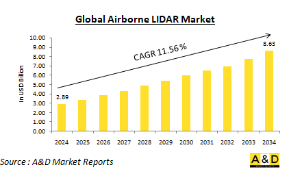
世界のエアボーンLiDAR市場は、2024年に28億9,000万米ドルと推定され、2024年から2034年の予測期間に11.56%の年間平均成長率 (CAGR) で拡大し、2034年までに86億3,000万米ドルに成長すると予測されます。
世界のエアボーンLiDAR市場の概要
エアボーンLiDARシステムは、地形マッピング、林業管理、都市計画、災害管理、環境モニタリングなど、さまざまな用途で活用されています。この技術は、デジタル標高モデルの作成、植生高さの評価、インフラのマッピングに使用できる高精度データを提供します。エアボーンLiDARの多用途性と精度は、航空宇宙、防衛、農業、土木工学などの産業にとって貴重なツールとなっています。市場の拡大には、詳細な地理データに対するニーズの高まりと、様々な分野でのLiDAR技術の採用拡大が寄与しています。都市化が加速し、環境への関心が高まるにつれ、正確なマッピングとモニタリングソリューションへの需要が顕著になっています。さらに、ドローン技術の進歩により、エアボーンLiDARシステムがより身近で費用対効果の高いものとなり、市場の成長をさらに促進しています。また、LiDARと地理情報システム (GIS) の統合により、その有用性が高まり、ユーザーはデータをより効果的に分析・視覚化できるようになりました。
世界のエアボーンLiDAR市場における技術の影響
技術進歩はエアボーンLiDAR市場に大きな影響を与え、この技術の能力と活用状況を向上させています。ガイガーモードLiDARや単一光子LiDARを含む、より洗練されたレーザーシステムの開発により、データ収集の分解能と精度が向上しました。これらの進歩により、従来の測量方法では困難であった密林や市街地のような複雑な環境でも、より詳細な情報を取得することができるようになりました。LiDARと無人航空機 (UAV) の統合は、費用対効果が高く効率的なデータ収集を広範囲で可能にし、市場に革命をもたらしました。LiDARセンサーを搭載したUAVは、手の届きにくい場所にもアクセスできるため、災害対応、環境モニタリング、インフラ検査などの用途に最適です。高解像度のデータを迅速かつ安全に収集できることから、UAVベースのLiDARシステムはさまざまな業界で人気が高まっています。さらに、データ処理ソフトウェアの進歩により、エアボーンLiDARプロジェクトに関連するワークフローが合理化されました。最新のソフトウェアソリューションは、大規模なデータセットを効率的に扱うことができるため、LiDARデータの迅速な処理と解析が可能です。この機能は、都市計画者や緊急対応者など、意思決定のためにタイムリーな情報を必要とする業界にとって極めて重要です。LiDARデータを航空画像などの他の地理空間情報と融合させることで、データセットの豊かさが増し、より包括的な洞察が得られます。
世界のエアボーンLiDAR市場の主な促進要因
いくつかの主要な促進要因がエアボーンLiDAR市場の成長を促進しています。主な要因の1つは、都市計画、林業、環境管理など様々な分野で高解像度マッピングの需要が高まっていることです。エアボーンLiDARシステムは、従来の測量手法では対応できない詳細さと精度を提供し、正確な地理データを作成するための不可欠なツールとなっています。このような詳細なマッピングに対するニーズの高まりが、エアボーンLiDAR技術の採用を大きく後押ししています。技術進歩もまた、市場を牽引する上で重要な役割を果たしています。レーザーシステムの強化、無人航空機 (UAV) との統合、データ処理能力の向上など、LiDAR技術における絶え間ない技術革新が市場成長に寄与しています。これらの進歩は、エアボーンLiDARシステムの性能と機能性を高めるだけでなく、より幅広いユーザーにとってより利用しやすく魅力的なものとなっています。技術の進化に伴い、エアボーンLiDARの能力と用途は拡大し続けています。航空宇宙・防衛分野でのエアボーンLiDARの採用拡大も重要な推進力となっています。これらの業界では、監視、偵察、地形マッピングなどの用途でLiDAR技術への依存が高まっています。堅牢な監視システムと正確な地理空間データへの需要が、これらの分野におけるLiDAR技術への大規模な投資を促し、市場の成長をさらに促進しています。環境モニタリングと災害管理もエアボーンLiDAR市場の拡大に貢献しています。自然災害の頻度増加や環境問題への関心の高まりにより、効果的なモニタリングや評価ツールの必要性が高まっています。エアボーンLiDARシステムは災害対応に非常に有効で、被災地に迅速な評価機能を提供し、詳細かつ正確なデータで復旧作業をサポートします。さらに、都市化とインフラ開発がエアボーンLiDARの需要を促進しています。都市が成長し、インフラプロジェクトが増加するにつれ、正確なマッピングとプランニングツールの必要性が高まっています。エアボーンLiDARは、インフラプロジェクトの効果的な計画、管理、実行に必要なデータを提供することで、都市開発イニシアチブをサポートする上で重要な役割を果たしています。高解像度で詳細な地図を提供するこの技術の能力は、効率的な都市計画と開発をサポートし、その普及をさらに加速させます。
世界のエアボーンLiDAR市場の地域別動向
エアボーンLiDAR市場は、技術導入、産業需要、政府の取り組みなど、様々な要因に影響された明確な地域別動向を示しています。北米では、大手企業の存在と技術への実質的な投資が主な要因となって、市場が最大となっています。特に米国は、LiDARをさまざまな用途に幅広く活用している航空宇宙・防衛分野の堅調さが際立っています。さらに、商業目的での無人航空機 (UAV) の採用が増加していることも、この地域の市場成長にさらに貢献しており、エアボーンLiDAR技術における北米のリーダーシップを浮き彫りにしています。欧州では、環境モニタリングと都市計画に重点が置かれていることが市場の特徴です。ドイツ、英国、フランスなどの国々は、インフラ開発をサポートし、包括的な環境評価を実施するために、エアボーンLiDAR技術に多額の投資を行っています。地理空間データ収集を強化するための欧州諸国間の協力的な取り組みも市場を後押ししており、これは地域全体で計画や管理を改善するためにLiDAR技術を活用しようとする協調的な取り組みを反映しています。アジア太平洋地域は、急速な都市化とインフラプロジェクトへの投資の増加により、エアボーンLiDAR市場の大幅な成長が見込まれています。中国、インド、日本のような国々は、都市計画から災害管理まで、多様な用途にLiDAR技術を採用しています。これらの国々ではスマートシティへの取り組みが重視されるようになっており、高解像度のマッピングソリューションへの需要がさらに高まっています。中東・アフリカでは、エアボーンLiDAR市場はインフラ整備と環境モニタリングの必要性によって形成されています。この地域の国々は、石油・ガス探査、都市計画、天然資源管理などの用途にLiDAR技術を活用するようになってきています。インフラ整備と天然資源管理に重点を置いていることが、この地域のニーズと優先事項の進化を反映し、エアボーンLiDARの採用を促進しています。ラテンアメリカでは、エアボーンLiDAR市場は他の地域に比べて比較的小さいもの、様々な分野でこの技術の利点が認識されつつあります。ブラジルやアルゼンチンのような国々は、環境モニタリングや都市開発のためのLiDARアプリケーションを模索し始めています。エアボーンLiDAR技術に対するこのような新たな関心は、これらの国々が開発と環境管理の取り組みを支援するために高度なマッピングソリューションを活用しようとしていることから、将来的な成長の可能性を示しています。
エアボーンLiDARの主要プログラム
Arete社は、水中の地雷、危険物、ターゲットの自動検出を目的とした無人航空機用LiDARセンサーを開発する予定です。米国海軍の研究者は、小型戦術無人航空機 (UAV) の地雷対策、無人水中航行体 (UUV) 探知、その他の目標識別タスクの能力を強化するため、実験的なエアボーンセンサーを必要としていました。彼らは、カリフォルニア州ノースリッジに拠点を置くArete Associates社から必要なソリューションを発見しました。
空軍のエンタープライズ施設契約を通じて収集されたエアボーン画像とLiDARデータは、ハリケーンに襲われたフロリダのティンダル空軍基地を含む将来の施設のデジタルインフラを強化し、強化しています。これらのデータソースの高い忠実度と精度は、施設内での自律走行車の将来的な配備や、明日のスマート施設を推進するセンサーの戦略的配置に不可欠です。
目次
エアボーンLiDAR市場:レポートの定義
エアボーンLiDAR市場の内訳
- 地域別
- エンドユーザー別
- 用途別
エアボーンLiDAR市場の分析 (今後10年間)
エアボーンLiDAR市場のマーケットテクノロジー
世界のエアボーンLiDAR市場の予測
エアボーンLiDAR市場:地域別の動向と予測
- 北米
- 促進・抑制要因、課題
- PEST分析
- 市場予測とシナリオ分析
- 主要企業
- サプライヤー階層の情勢
- 企業のベンチマーク
- 欧州
- 中東
- アジア太平洋
- 南米
エアボーンLiDAR市場:国別分析
- 米国
- 防衛計画
- 最新動向
- 特許
- この市場における現在の技術成熟レベル
- 市場予測とシナリオ分析
- カナダ
- イタリア
- フランス
- ドイツ
- オランダ
- ベルギー
- スペイン
- スウェーデン
- ギリシャ
- オーストラリア
- 南アフリカ
- インド
- 中国
- ロシア
- 韓国
- 日本
- マレーシア
- シンガポール
- ブラジル
エアボーンLiDAR市場:市場機会マトリックス
エアボーンLiDAR市場:調査に関する専門家の見解
結論
Aviation and Defense Market Reportsについて
List of Tables
- Table 1: 10 Year Market Outlook, 2024-2034
- Table 2: Drivers, Impact Analysis, North America
- Table 3: Restraints, Impact Analysis, North America
- Table 4: Challenges, Impact Analysis, North America
- Table 5: Drivers, Impact Analysis, Europe
- Table 6: Restraints, Impact Analysis, Europe
- Table 7: Challenges, Impact Analysis, Europe
- Table 8: Drivers, Impact Analysis, Middle East
- Table 9: Restraints, Impact Analysis, Middle East
- Table 10: Challenges, Impact Analysis, Middle East
- Table 11: Drivers, Impact Analysis, APAC
- Table 12: Restraints, Impact Analysis, APAC
- Table 13: Challenges, Impact Analysis, APAC
- Table 14: Drivers, Impact Analysis, South America
- Table 15: Restraints, Impact Analysis, South America
- Table 16: Challenges, Impact Analysis, South America
- Table 17: Scenario Analysis, Scenario 1, By Region, 2024-2034
- Table 18: Scenario Analysis, Scenario 1, By End User, 2024-2034
- Table 19: Scenario Analysis, Scenario 1, By Application, 2024-2034
- Table 20: Scenario Analysis, Scenario 2, By Region, 2024-2034
- Table 21: Scenario Analysis, Scenario 2, By End User, 2024-2034
- Table 22: Scenario Analysis, Scenario 2, By Application, 2024-2034
List of Figures
- Figure 1: Global Airborne LIDAR Market Forecast, 2024-2034
- Figure 2: Global Airborne LIDAR Market Forecast, By Region, 2024-2034
- Figure 3: Global Airborne LIDAR Market Forecast, By End User, 2024-2034
- Figure 4: Global Airborne LIDAR Market Forecast, By Application, 2024-2034
- Figure 5: North America, Airborne LIDAR Market, Market Forecast, 2024-2034
- Figure 6: Europe, Airborne LIDAR Market, Market Forecast, 2024-2034
- Figure 7: Middle East, Airborne LIDAR Market, Market Forecast, 2024-2034
- Figure 8: APAC, Airborne LIDAR Market, Market Forecast, 2024-2034
- Figure 9: South America, Airborne LIDAR Market, Market Forecast, 2024-2034
- Figure 10: United States, Airborne LIDAR Market, Technology Maturation, 2024-2034
- Figure 11: United States, Airborne LIDAR Market, Market Forecast, 2024-2034
- Figure 12: Canada, Airborne LIDAR Market, Technology Maturation, 2024-2034
- Figure 13: Canada, Airborne LIDAR Market, Market Forecast, 2024-2034
- Figure 14: Italy, Airborne LIDAR Market, Technology Maturation, 2024-2034
- Figure 15: Italy, Airborne LIDAR Market, Market Forecast, 2024-2034
- Figure 16: France, Airborne LIDAR Market, Technology Maturation, 2024-2034
- Figure 17: France, Airborne LIDAR Market, Market Forecast, 2024-2034
- Figure 18: Germany, Airborne LIDAR Market, Technology Maturation, 2024-2034
- Figure 19: Germany, Airborne LIDAR Market, Market Forecast, 2024-2034
- Figure 20: Netherlands, Airborne LIDAR Market, Technology Maturation, 2024-2034
- Figure 21: Netherlands, Airborne LIDAR Market, Market Forecast, 2024-2034
- Figure 22: Belgium, Airborne LIDAR Market, Technology Maturation, 2024-2034
- Figure 23: Belgium, Airborne LIDAR Market, Market Forecast, 2024-2034
- Figure 24: Spain, Airborne LIDAR Market, Technology Maturation, 2024-2034
- Figure 25: Spain, Airborne LIDAR Market, Market Forecast, 2024-2034
- Figure 26: Sweden, Airborne LIDAR Market, Technology Maturation, 2024-2034
- Figure 27: Sweden, Airborne LIDAR Market, Market Forecast, 2024-2034
- Figure 28: Brazil, Airborne LIDAR Market, Technology Maturation, 2024-2034
- Figure 29: Brazil, Airborne LIDAR Market, Market Forecast, 2024-2034
- Figure 30: Australia, Airborne LIDAR Market, Technology Maturation, 2024-2034
- Figure 31: Australia, Airborne LIDAR Market, Market Forecast, 2024-2034
- Figure 32: India, Airborne LIDAR Market, Technology Maturation, 2024-2034
- Figure 33: India, Airborne LIDAR Market, Market Forecast, 2024-2034
- Figure 34: China, Airborne LIDAR Market, Technology Maturation, 2024-2034
- Figure 35: China, Airborne LIDAR Market, Market Forecast, 2024-2034
- Figure 36: Saudi Arabia, Airborne LIDAR Market, Technology Maturation, 2024-2034
- Figure 37: Saudi Arabia, Airborne LIDAR Market, Market Forecast, 2024-2034
- Figure 38: South Korea, Airborne LIDAR Market, Technology Maturation, 2024-2034
- Figure 39: South Korea, Airborne LIDAR Market, Market Forecast, 2024-2034
- Figure 40: Japan, Airborne LIDAR Market, Technology Maturation, 2024-2034
- Figure 41: Japan, Airborne LIDAR Market, Market Forecast, 2024-2034
- Figure 42: Malaysia, Airborne LIDAR Market, Technology Maturation, 2024-2034
- Figure 43: Malaysia, Airborne LIDAR Market, Market Forecast, 2024-2034
- Figure 44: Singapore, Airborne LIDAR Market, Technology Maturation, 2024-2034
- Figure 45: Singapore, Airborne LIDAR Market, Market Forecast, 2024-2034
- Figure 46: United Kingdom, Airborne LIDAR Market, Technology Maturation, 2024-2034
- Figure 47: United Kingdom, Airborne LIDAR Market, Market Forecast, 2024-2034
- Figure 48: Opportunity Analysis, Airborne LIDAR Market, By Region (Cumulative Market), 2024-2034
- Figure 49: Opportunity Analysis, Airborne LIDAR Market, By Region (CAGR), 2024-2034
- Figure 50: Opportunity Analysis, Airborne LIDAR Market, By End User (Cumulative Market), 2024-2034
- Figure 51: Opportunity Analysis, Airborne LIDAR Market, By End User (CAGR), 2024-2034
- Figure 52: Opportunity Analysis, Airborne LIDAR Market, By Application (Cumulative Market), 2024-2034
- Figure 53: Opportunity Analysis, Airborne LIDAR Market, By Application (CAGR), 2024-2034
- Figure 54: Scenario Analysis, Airborne LIDAR Market, Cumulative Market, 2024-2034
- Figure 55: Scenario Analysis, Airborne LIDAR Market, Global Market, 2024-2034
- Figure 56: Scenario 1, Airborne LIDAR Market, Total Market, 2024-2034
- Figure 57: Scenario 1, Airborne LIDAR Market, By Region, 2024-2034
- Figure 58: Scenario 1, Airborne LIDAR Market, By End User, 2024-2034
- Figure 59: Scenario 1, Airborne LIDAR Market, By Application, 2024-2034
- Figure 60: Scenario 2, Airborne LIDAR Market, Total Market, 2024-2034
- Figure 61: Scenario 2, Airborne LIDAR Market, By Region, 2024-2034
- Figure 62: Scenario 2, Airborne LIDAR Market, By End User, 2024-2034
- Figure 63: Scenario 2, Airborne LIDAR Market, By Application, 2024-2034
- Figure 64: Company Benchmark, Airborne LIDAR Market, 2024-2034
The Global Airborne LIDAR Market is estimated at USD 2.89 billion in 2024, projected to grow to USD 8.63 billion by 2034 at a Compound Annual Growth Rate (CAGR) of 11.56% over the forecast period 2024-2034
Introduction to the Airborne LiDAR Market:
Airborne LiDAR systems are utilized in a variety of applications, including topographic mapping, forestry management, urban planning, disaster management, and environmental monitoring. The technology provides highly accurate data that can be used for creating digital elevation models, assessing vegetation height, and mapping infrastructure. The versatility and precision of airborne LiDAR make it an invaluable tool for industries such as aerospace, defense, agriculture, and civil engineering. The market's expansion is fueled by the increasing need for detailed geographical data and the growing adoption of LiDAR technology in various sectors. As urbanization accelerates and environmental concerns rise, the demand for accurate mapping and monitoring solutions has become more pronounced. Additionally, advancements in drone technology have made airborne LiDAR systems more accessible and cost-effective, further driving market growth. The integration of LiDAR with Geographic Information Systems (GIS) has also enhanced its utility, enabling users to analyze and visualize data more effectively.
Technology Impact in the Airborne LiDAR Market:
Technological advancements have significantly impacted the airborne LiDAR market, enhancing the capabilities and applications of this technology. The development of more sophisticated laser systems, including Geiger-mode and single-photon LiDAR, has improved the resolution and accuracy of data collection. These advancements allow for the capture of finer details in complex environments, such as dense forests or urban areas, where traditional surveying methods may struggle. The integration of LiDAR with unmanned aerial vehicles (UAVs) has revolutionized the market by enabling cost-effective and efficient data collection over large areas. UAVs equipped with LiDAR sensors can access hard-to-reach locations, making them ideal for applications such as disaster response, environmental monitoring, and infrastructure inspection. The ability to collect high-resolution data quickly and safely has made UAV-based LiDAR systems increasingly popular among various industries. Furthermore, advancements in data processing software have streamlined the workflow associated with airborne LiDAR projects. Modern software solutions can handle large datasets efficiently, allowing for rapid processing and analysis of LiDAR data. This capability is crucial for industries that require timely information for decision-making, such as urban planners and emergency responders. The fusion of LiDAR data with other geospatial information, such as aerial imagery, enhances the richness of the datasets and provides more comprehensive insights.
Key Drivers in the Airborne LiDAR Market:
Several key drivers are propelling the growth of the airborne LiDAR market. One of the primary factors is the increased demand for high-resolution mapping across various sectors such as urban planning, forestry, and environmental management. Airborne LiDAR systems offer a level of detail and accuracy that traditional surveying methods cannot match, making them essential tools for generating precise geographical data. This growing need for detailed mapping is significantly boosting the adoption of airborne LiDAR technology. Technological advancements also play a crucial role in driving the market. Continuous innovations in LiDAR technology, including enhancements in laser systems, integration with unmanned aerial vehicles (UAVs), and improvements in data processing capabilities, are contributing to market growth. These advancements not only enhance the performance and functionality of airborne LiDAR systems but also make them more accessible and appealing to a wider range of users. As technology evolves, the capabilities and applications of airborne LiDAR continue to expand. The growing adoption of airborne LiDAR in the aerospace and defense sectors is another significant driver. These industries increasingly rely on LiDAR technology for applications such as surveillance, reconnaissance, and terrain mapping. The demand for robust surveillance systems and accurate geospatial data is prompting substantial investments in LiDAR technology within these sectors, further fueling market growth. Environmental monitoring and disaster management are also contributing to the expansion of the airborne LiDAR market. The rising frequency of natural disasters and growing environmental concerns have heightened the need for effective monitoring and assessment tools. Airborne LiDAR systems are invaluable for disaster response, providing rapid assessment capabilities for affected areas and supporting recovery efforts with detailed and accurate data. Additionally, urbanization and infrastructure development are driving the demand for airborne LiDAR. As cities grow and infrastructure projects increase, there is a heightened need for accurate mapping and planning tools. Airborne LiDAR plays a critical role in supporting urban development initiatives by providing the necessary data for effective planning, management, and execution of infrastructure projects. The technology's ability to deliver high-resolution, detailed maps supports efficient urban planning and development, further accelerating its adoption.
Regional Trends in the Airborne LiDAR Market:
The airborne LiDAR market exhibits distinct regional trends influenced by various factors, including technological adoption, industry demand, and government initiatives. In North America, the market is the largest, driven primarily by the presence of key industry players and substantial investments in technology. The United States, in particular, stands out with its robust aerospace and defense sector, which extensively utilizes LiDAR for a range of applications. Additionally, the increasing adoption of unmanned aerial vehicles (UAVs) for commercial purposes is further contributing to market growth in this region, highlighting North America's leadership in airborne LiDAR technology. In Europe, the market is characterized by a strong focus on environmental monitoring and urban planning. Countries such as Germany, the UK, and France are making significant investments in airborne LiDAR technology to support infrastructure development and conduct comprehensive environmental assessments. The collaborative initiatives among European nations to enhance geospatial data collection are also boosting the market, reflecting a concerted effort to leverage LiDAR technology for improved planning and management across the region. The Asia-Pacific region is anticipated to experience substantial growth in the airborne LiDAR market, driven by rapid urbanization and increasing investments in infrastructure projects. Nations like China, India, and Japan are adopting LiDAR technology for diverse applications, from urban planning to disaster management. The growing emphasis on smart city initiatives in these countries is further propelling the demand for high-resolution mapping solutions, highlighting the region's expanding role in the global LiDAR market. In the Middle East and Africa, the airborne LiDAR market is shaped by the need for infrastructure development and environmental monitoring. Countries in this region are increasingly utilizing LiDAR technology for applications such as oil and gas exploration, urban planning, and natural resource management. The focus on developing infrastructure and managing natural resources is driving the adoption of airborne LiDAR, reflecting the region's evolving needs and priorities. In Latin America, although the airborne LiDAR market is relatively smaller compared to other regions, there is a growing recognition of the technology's benefits across various sectors. Countries like Brazil and Argentina are beginning to explore LiDAR applications for environmental monitoring and urban development. This emerging interest in airborne LiDAR technology indicates a potential for future growth as these countries seek to leverage advanced mapping solutions to support their development and environmental management efforts.
Key Airborne LiDAR Market Program:
Arete is set to develop a lidar sensor for uncrewed aircraft to automate the detection of underwater mines, hazards, and targets. U.S. Navy researchers required an experimental airborne sensor to enhance the capabilities of small tactical uncrewed aerial vehicles (UAVs) for mine countermeasures, uncrewed underwater vehicle (UUV) detection, and other target identification tasks. They discovered the solution they needed from Arete Associates based in Northridge, Calif.
Airborne imagery and LiDAR data collected through an Air Force enterprise installations contract have been enhancing and strengthening the digital infrastructure for future installations, including hurricane-affected Tyndall Air Force Base in Florida. The high fidelity and accuracy of these data sources are essential for the future deployment of autonomous vehicles on installations and for the strategic placement of sensors that will drive the smart facilities of tomorrow.
Table of Contents
Airborne LIDAR Market Report Definition
Airborne LIDAR Market Segmentation
By Region
By End-User
By Application
Airborne LIDAR Market Analysis for next 10 Years
The 10-year Airborne LIDAR Market analysis would give a detailed overview of Airborne LIDAR Market growth, changing dynamics, technology adoption overviews and the overall market attractiveness is covered in this chapter.
Market Technologies of Airborne LIDAR Market
This segment covers the top 10 technologies that is expected to impact this market and the possible implications these technologies would have on the overall market.
Global Airborne LIDAR Market Forecast
The 10-year Airborne LIDAR Market forecast of this market is covered in detailed across the segments which are mentioned above.
Regional Airborne LIDAR Market Trends & Forecast
The regional Airborne LIDAR Market trends, drivers, restraints and Challenges of this market, the Political, Economic, Social and Technology aspects are covered in this segment. The market forecast and scenario analysis across regions are also covered in detailed in this segment. The last part of the regional analysis includes profiling of the key companies, supplier landscape and company benchmarking. The current market size is estimated based on the normal scenario.
North America
Drivers, Restraints and Challenges
PEST
Market Forecast & Scenario Analysis
Key Companies
Supplier Tier Landscape
Company Benchmarking
Europe
Middle East
APAC
South America
Country Analysis of Airborne LIDAR Market
This chapter deals with the key defense programs in this market, it also covers the latest news and patents which have been filed in this market. Country level 10 year market forecast and scenario analysis are also covered in this chapter.
US
Defense Programs
Latest News
Patents
Current levels of technology maturation in this market
Market Forecast & Scenario Analysis
Canada
Italy
France
Germany
Netherlands
Belgium
Spain
Sweden
Greece
Australia
South Africa
India
China
Russia
South Korea
Japan
Malaysia
Singapore
Brazil
Opportunity Matrix for Airborne LIDAR Market
The opportunity matrix helps the readers understand the high opportunity segments in this market.
Expert Opinions on Airborne LIDAR Market Report
Hear from our experts their opinion of the possible analysis for this market.
Conclusions
About Aviation and Defense Market Reports

